TopoQuest Logo
Do you find TopoQuest useful?
Help keep TopoQuest running and adding new maps/features by donating!
Bitcoin:  19c7KJd3qBynnjoSw5npx9KScwjBe4ifkT
Litecoin:  LXs6TkuXGGXo1vDsWCkWVdjQX94eUKd6ui
Home View Maps Find Maps Find Places Resources & Links


Fordyce, Arkansas Topographic Map

USGS Map Title: Fordyce, AR
USGS Map MRC: 33092G4
DRG (GeoTIFF) Download: o33092g4.tif


Neighboring USGS Topographic Map Quads:


  Princeton East, AR  
33092H5
 

  Ivan, AR  
33092H4
 

  Fordyce NE, AR  
33092H3
 

  Hopeville, AR  
33092G5
 

  Fordyce, AR  
33092G4
 

  Kingsland, AR  
33092G3
 

  Bearden, AR  
33092F5
 

  Chambersville, AR  
33092F4
 

  Tinsman, AR  
33092F3


Map MRC Location:

N34°
W93°
N34°
W92°
H8 H7 H6 H5 H4 H3 H2 H1
G8 G7 G6 G5 G4 G3 G2 G1
F8 F7 F6 F5 F4 F3 F2 F1
E8 E7 E6 E5 E4 E3 E2 E1
D8 D7 D6 D5 D4 D3 D2 D1
C8 C7 C6 C5 C4 C3 C2 C1
B8 B7 B6 B5 B4 B3 B2 B1
A8 A7 A6 A5 A4 A3 A2 A1
N33°
W93°
N33°
W92°

Fordyce, AR USGS 1:24K Topographic Map Preview:
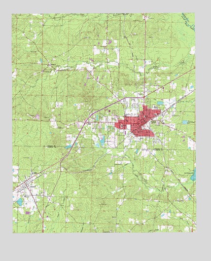
Fordyce, AR USGS Topographic Map
Click on map above to begin viewing in our Map Viewer.

This topographic map contains these locations and features:
Feature Name Type Latitude Longitude GNIS ID View Map
Barnes CemeteryCemeteryN33.8614°W92.4504°46100View Map
Beech GrovePopulated PlaceN33.8132°W92.4485°57353View Map
Bryant CemeteryCemeteryN33.8705°W92.4132°47100View Map
BucksnortPopulated PlaceN33.8457°W92.4743°76455View Map
Chambersville ChurchChurchN33.7507°W92.4329°47680View Map
Charlotte Street Historic DistrictParkN33.8176°W92.4085°63133View Map
City of FordyceCivilN33.8181°W92.4176°2403630View Map
City of ThorntonCivilN33.7756°W92.4890°2405588View Map
Cooterneck Volunteer Fire StationBuildingN33.8720°W92.4097°2116302View Map
Dallas County CourthouseBuildingN33.8126°W92.4140°60967View Map
Dallas County Hospital HeliportAirportN33.8112°W92.4257°83703View Map
Dallas County Medical CenterHospitalN33.8111°W92.4257°60968View Map
Dallas County Sheriff's OfficeBuildingN33.8132°W92.4058°2118827View Map
EbenezerPopulated PlaceN33.7676°W92.3929°61605View Map
Ebenezer ChurchChurchN33.7684°W92.3843°48804View Map
Emergency Ambulance Service FordyceBuildingN33.8118°W92.4221°2119050View Map
Enon ChurchChurchN33.7584°W92.4302°48901View Map
First Baptist ChurchChurchN33.8148°W92.4140°63135View Map
First Presbyterian ChurchChurchN33.8129°W92.4149°63136View Map
First United Methodist ChurchChurchN33.8143°W92.4121°63137View Map
FordycePopulated PlaceN33.8137°W92.4129°49160View Map
Fordyce Country ClubLocaleN33.8101°W92.4696°82431View Map
Fordyce Elementary SchoolSchoolN33.8204°W92.4333°2093350View Map
Fordyce Fire DepartmentBuildingN33.8120°W92.4128°2116436View Map
Fordyce High SchoolSchoolN33.8194°W92.4340°60969View Map
Fordyce Middle SchoolSchoolN33.8186°W92.4334°60970View Map
Fordyce Police DepartmentBuildingN33.8099°W92.4107°2118826View Map
Fordyce Post OfficePost OfficeN33.8121°W92.4213°2781921View Map
Greenville CemeteryCemeteryN33.7970°W92.4065°49666View Map
J E Wallace Elementary School (historical)SchoolN33.8173°W92.4027°83934View Map
Jacobs LakeReservoirN33.8482°W92.4801°80175View Map
Jacobs Lake DamDamN33.8468°W92.4802°80174View Map
KBJT-AM (Fordyce)TowerN33.8048°W92.4354°85299View Map
Kervin Lake Dam Number One DamDamN33.8568°W92.4335°80176View Map
Kervin Lake Number OneReservoirN33.8587°W92.4333°80177View Map
KQEW-FM (Fordyce)TowerN33.8048°W92.4354°85391View Map
Lake CathayReservoirN33.7679°W92.4953°80734View Map
Lake Cathay DamDamN33.7668°W92.4952°80733View Map
Lake LansdaleReservoirN33.7992°W92.4618°80173View Map
Lake Lansdale DamDamN33.8001°W92.4602°80172View Map
Mount Paron ChurchChurchN33.8534°W92.4835°52368View Map
Mount Zion CemeteryCemeteryN33.7929°W92.4882°52441View Map
North FordycePopulated PlaceN33.8251°W92.4118°56795View Map
Oakland CemeteryCemeteryN33.8214°W92.4035°52953View Map
Patterson Grammar School (historical)SchoolN33.8185°W92.4334°60975View Map
Pilgrims Rest ChurchChurchN33.7895°W92.4263°53387View Map
Pine Crest ChurchChurchN33.8562°W92.4365°53418View Map
Stony Point ChurchChurchN33.8423°W92.4793°55254View Map
Stroud CemeteryCemeteryN33.7662°W92.4399°55277View Map
The Mall Shopping CenterLocaleN33.8137°W92.4218°60978View Map
ThorntonPopulated PlaceN33.7790°W92.4918°55554View Map
Thornton Fire StationBuildingN33.7755°W92.4915°2117207View Map
Thornton Post OfficePost OfficeN33.7770°W92.4911°2781890View Map
Township of FordyceCivilN33.8430°W92.4326°66486View Map
Township of Moro (historical)CivilN33.7543°W92.4168°63706View Map

Note: Coordinates in the location and feature list above are referenced to NAD83 datum.


Copyright (C) 2008-2025 Ryan Niemi / Sunset Dynamics ... All Rights Reserved