TopoQuest Logo
Do you find TopoQuest useful?
Help keep TopoQuest running and adding new maps/features by donating!
Bitcoin:  19c7KJd3qBynnjoSw5npx9KScwjBe4ifkT
Litecoin:  LXs6TkuXGGXo1vDsWCkWVdjQX94eUKd6ui
Home View Maps Find Maps Find Places Resources & Links


Medanales, New Mexico Topographic Map

USGS Map Title: Medanales, NM
USGS Map MRC: 36106B2
DRG (GeoTIFF) Download: o36106b2.tif


Neighboring USGS Topographic Map Quads:


  Canjilon SE, NM  
36106C3
 

  El Rito, NM  
36106C2
 

  Ojo Caliente, NM  
36106C1
 

  Abiquiu, NM  
36106B3
 

  Medanales, NM  
36106B2
 

  Lyden, NM  
36106B1
 

  Vallecitos, NM  
36106A3
 

  Chili, NM  
36106A2
 

  San Juan Pueblo, NM  
36106A1


Map MRC Location:

N37°
W107°
N37°
W106°
H8 H7 H6 H5 H4 H3 H2 H1
G8 G7 G6 G5 G4 G3 G2 G1
F8 F7 F6 F5 F4 F3 F2 F1
E8 E7 E6 E5 E4 E3 E2 E1
D8 D7 D6 D5 D4 D3 D2 D1
C8 C7 C6 C5 C4 C3 C2 C1
B8 B7 B6 B5 B4 B3 B2 B1
A8 A7 A6 A5 A4 A3 A2 A1
N36°
W107°
N36°
W106°

Medanales, NM USGS 1:24K Topographic Map Preview:
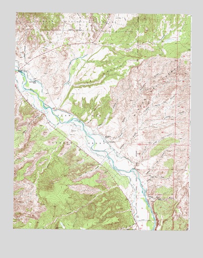
Medanales, NM USGS Topographic Map
Click on map above to begin viewing in our Map Viewer.

This topographic map contains these locations and features:
Feature Name Type Latitude Longitude GNIS ID View Map
Abiquiu Fire Protection District Main StationBuildingN36.2230°W106.2371°2658120View Map
Abiquiu Fire Protection District Station 2BuildingN36.1729°W106.1791°2657613View Map
Arroyo de AguaStreamN36.1503°W106.1592°903310View Map
Arroyo de las LemitasStreamN36.1272°W106.1500°928682View Map
Arroyo de los PinavetesStreamN36.1664°W106.1825°928683View Map
Arroyo del CerritoStreamN36.1603°W106.1653°903325View Map
Arroyo del PerroStreamN36.2253°W106.2011°903338View Map
Arroyo del Perro del OesteStreamN36.2389°W106.2034°902877View Map
Arroyo del ToroStreamN36.1445°W106.1564°903344View Map
Arroyo las LagunitasStreamN36.2320°W106.1914°903349View Map
Arroyo PonilStreamN36.1853°W106.2009°903408View Map
Caņada AnchaStreamN36.1670°W106.1750°904429View Map
Caņada Ancha del NorteStreamN36.1834°W106.1614°904435View Map
Caņada de HornoStreamN36.1931°W106.2278°904376View Map
Caņada de las LemitasStreamN36.1547°W106.1611°904422View Map
Caņada de los AlamosStreamN36.1451°W106.1570°2677635View Map
Caņada de Tio AlfonsoStreamN36.1809°W106.1970°904384View Map
Caņada HondaStreamN36.1734°W106.1817°904457View Map
Caņon la MaderaValleyN36.1789°W106.1972°904606View Map
El RitoStreamN36.1978°W106.2292°928725View Map
Llano LobatoRidgeN36.2131°W106.1900°908091View Map
Madera TrailTrailN36.1633°W106.2064°2681458View Map
MedanalesPopulated PlaceN36.1756°W106.1834°908556View Map
Medanales Post OfficePost OfficeN36.1714°W106.1779°937511View Map
Quarter Circle RanchLocaleN36.2103°W106.2359°909918View Map
RG-12541 Water WellWellN36.1954°W106.2346°926552View Map
RG-15335 Water WellWellN36.1353°W106.1692°926422View Map
RG-17400 Water WellWellN36.2145°W106.2408°926454View Map
RG-18262 Water WellWellN36.1936°W106.2245°926442View Map
RG-19249 Water WellWellN36.1875°W106.2275°926437View Map
RG-19392 Water WellWellN36.1772°W106.1970°926553View Map
RG-23556 Water WellWellN36.2020°W106.2361°926541View Map
RG-28313 Water WellWellN36.1758°W106.1828°926436View Map
RG-3300 Water WellWellN36.1678°W106.1672°926433View Map
RG-5325 Water WellWellN36.1775°W106.1867°926554View Map
Rincon Del CuervoRidgeN36.2067°W106.1503°910194View Map
Rio Chama DivisionCivilN36.2462°W106.2401°1937577View Map
San Antonio ChurchChurchN36.1775°W106.1853°910601View Map
Sierra Negra TankReservoirN36.2427°W106.2150°2677644View Map
Tierra AzulPopulated PlaceN36.2067°W106.2486°901462View Map
Window RockArchN36.1264°W106.2189°2632197View Map
Window Rock Trick TankReservoirN36.1286°W106.2153°2677645View Map

Note: Coordinates in the location and feature list above are referenced to NAD83 datum.


Copyright (C) 2008-2025 Ryan Niemi / Sunset Dynamics ... All Rights Reserved