TopoQuest Logo
Do you find TopoQuest useful?
Help keep TopoQuest running and adding new maps/features by donating!
Bitcoin:  19c7KJd3qBynnjoSw5npx9KScwjBe4ifkT
Litecoin:  LXs6TkuXGGXo1vDsWCkWVdjQX94eUKd6ui
Home View Maps Find Maps Find Places Resources & Links


Vallecitos, New Mexico Topographic Map

USGS Map Title: Vallecitos, NM
USGS Map MRC: 36106A3
DRG (GeoTIFF) Download: o36106a3.tif


Neighboring USGS Topographic Map Quads:


  Canones, NM  
36106B4
 

  Abiquiu, NM  
36106B3
 

  Medanales, NM  
36106B2
 

  Polvadera Peak, NM  
36106A4
 

  Vallecitos, NM  
36106A3
 

  Chili, NM  
36106A2
 

  Valle Toledo, NM  
35106H4
 

  Guaje Mountain, NM  
35106H3
 

  Puye, NM  
35106H2


Map MRC Location:

N37°
W107°
N37°
W106°
H8 H7 H6 H5 H4 H3 H2 H1
G8 G7 G6 G5 G4 G3 G2 G1
F8 F7 F6 F5 F4 F3 F2 F1
E8 E7 E6 E5 E4 E3 E2 E1
D8 D7 D6 D5 D4 D3 D2 D1
C8 C7 C6 C5 C4 C3 C2 C1
B8 B7 B6 B5 B4 B3 B2 B1
A8 A7 A6 A5 A4 A3 A2 A1
N36°
W107°
N36°
W106°

Vallecitos, NM USGS 1:24K Topographic Map Preview:
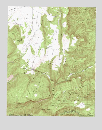
Vallecitos, NM USGS Topographic Map
Click on map above to begin viewing in our Map Viewer.

This topographic map contains these locations and features:
Feature Name Type Latitude Longitude GNIS ID View Map
Apache TrailTrailN36.1161°W106.2803°2038350View Map
Arroyo AnimaStreamN36.1031°W106.3309°903287View Map
Augustine TankReservoirN36.0697°W106.3237°915797View Map
Caņada de ComancheStreamN36.0445°W106.3156°904373View Map
Caņada de IndioStreamN36.0486°W106.3248°904405View Map
Caņada de la CorralesStreamN36.1064°W106.3025°904352View Map
Caņoncito de los RanchosValleyN36.0500°W106.3289°904708View Map
Caņoncito Tia TonaValleyN36.0786°W106.3270°904717View Map
Cerrito del ChibatoSummitN36.1078°W106.3170°904904View Map
Corrales TankReservoirN36.1150°W106.3023°2038421View Map
Cuchillas Trick TankReservoirN36.0997°W106.3145°2038428View Map
Curve TankReservoirN36.0652°W106.3021°905567View Map
El AltoAreaN36.1175°W106.3564°906027View Map
El Banco del ApacheValleyN36.0650°W106.2884°906031View Map
El CanonValleyN36.0547°W106.2620°2038796View Map
El CaņoncitoValleyN36.0953°W106.3492°906039View Map
Forest RoadMineN36.0314°W106.2881°917072View Map
Gallina CreekStreamN36.0378°W106.3028°923602View Map
La BentoleraRidgeN36.0622°W106.2928°907606View Map
La CanadaStreamN36.0803°W106.3284°907610View Map
La Canada del CerroStreamN36.0553°W106.2606°907615View Map
La Cuchilla de la MonjoneraCliffN36.0597°W106.3139°907627View Map
La Joya Tio GregorioValleyN36.0931°W106.3395°907669View Map
La SotellaSummitN36.0886°W106.2836°907722View Map
La UtahSummitN36.0664°W106.2700°907725View Map
Las CuchillasRidgeN36.0900°W106.2989°928753View Map
Loma PardaSummitN36.0736°W106.3392°908135View Map
Los CerritosSummitN36.0278°W106.2870°908200View Map
Los CerritosSummitN36.0872°W106.3561°908201View Map
Los CerrosSummitN36.0261°W106.2597°908205View Map
Los PososSummitN36.0311°W106.3084°908227View Map
Lucas TankReservoirN36.0878°W106.3254°908299View Map
Mesa de la GallinaBenchN36.0295°W106.3342°908603View Map
Mesa del OjitoSummitN36.0170°W106.3011°908583View Map
Mesa del TerreroSummitN36.0228°W106.3067°908585View Map
Oso CanyonValleyN36.0525°W106.3406°909384View Map
Peņasco BlancoSummitN36.0175°W106.2945°909546View Map
RecheulosPopulated PlaceN36.0528°W106.3389°910036View Map
Rincon de MoraRidgeN36.0956°W106.3642°910180View Map
Rio del Oso Ranger StationLocaleN36.0534°W106.3484°910227View Map
Rito de AbiquiuStreamN36.0397°W106.3706°910274View Map
Rito del OsoStreamN36.0397°W106.3706°928796View Map
Salazar TankReservoirN36.0771°W106.2911°910556View Map
San LorenzoPopulated PlaceN36.0486°W106.2853°910651View Map
San Lorenzo Elementary SchoolSchoolN36.0486°W106.2853°914677View Map
San Lorenzo Post Office (historical)Post OfficeN36.0486°W106.2853°938504View Map
San Lorenzo SpringSpringN36.0414°W106.2923°910653View Map
San Lorenzo TrailTrailN36.0592°W106.2872°2038665View Map
Santa Clara Ranger StationLocaleN36.0059°W106.2892°910777View Map
VallecitosPopulated PlaceN36.0906°W106.3389°912053View Map
Vallecitos CorralesPopulated PlaceN36.0667°W106.3561°912061View Map
Vallecitos De Los ChamisosValleyN36.1017°W106.3075°912063View Map
Vallecitos de los Chamisos TankReservoirN36.0788°W106.3156°912057View Map
Vallecitos United Methodist ChurchChurchN36.0906°W106.3389°902458View Map

Note: Coordinates in the location and feature list above are referenced to NAD83 datum.


Copyright (C) 2008-2025 Ryan Niemi / Sunset Dynamics ... All Rights Reserved