TopoQuest Logo
Do you find TopoQuest useful?
Help keep TopoQuest running and adding new maps/features by donating!
Bitcoin:  19c7KJd3qBynnjoSw5npx9KScwjBe4ifkT
Litecoin:  LXs6TkuXGGXo1vDsWCkWVdjQX94eUKd6ui
Home View Maps Find Maps Find Places Resources & Links


Medicine Lake, California Topographic Map

USGS Map Title: Medicine Lake, CA
USGS Map MRC: 41121E5
DRG (GeoTIFF) Download: o41121e5.tif


Neighboring USGS Topographic Map Quads:


  Bonita Butte, CA  
41121F6
 

  Schonchin Butte, CA  
41121F5
 

  Caldwell Butte, CA  
41121F4
 

  Little Glass Mountain, CA  
41121E6
 

  Medicine Lake, CA  
41121E5
 

  West of Kephart, CA  
41121E4
 

  Snag Hill, CA  
41121D6
 

  Porcupine Butte, CA  
41121D5
 

  Border Mountain, CA  
41121D4


Map MRC Location:

N42°
W122°
N42°
W121°
H8 H7 H6 H5 H4 H3 H2 H1
G8 G7 G6 G5 G4 G3 G2 G1
F8 F7 F6 F5 F4 F3 F2 F1
E8 E7 E6 E5 E4 E3 E2 E1
D8 D7 D6 D5 D4 D3 D2 D1
C8 C7 C6 C5 C4 C3 C2 C1
B8 B7 B6 B5 B4 B3 B2 B1
A8 A7 A6 A5 A4 A3 A2 A1
N41°
W122°
N41°
W121°

Medicine Lake, CA USGS 1:24K Topographic Map Preview:
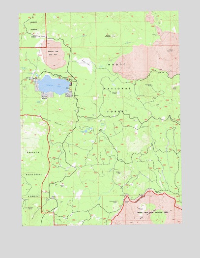
Medicine Lake, CA USGS Topographic Map
Click on map above to begin viewing in our Map Viewer.

This topographic map contains these locations and features:
Feature Name Type Latitude Longitude GNIS ID View Map
Alcohol CraterCraterN41.5771°W121.5492°1657737View Map
Arnica SinkBasinN41.5952°W121.5744°256325View Map
Blanche LakeLakeN41.5566°W121.5708°257198View Map
Brownell MeadowFlatN41.5765°W121.6075°257499View Map
Bruin FlatFlatN41.5238°W121.5939°257522View Map
Bullseye LakeLakeN41.5552°W121.5751°257681View Map
Burnt Lava Flow Geological AreaAreaN41.5088°W121.5224°276756View Map
Crystal SpringsSpringN41.5732°W121.6093°258972View Map
Glass MountainSummitN41.6015°W121.5044°260593View Map
High Hole CraterCraterN41.5090°W121.5314°261319View Map
Hot SpotPillarN41.6054°W121.5239°261554View Map
Iodine PrairieAreaN41.5168°W121.6006°261798View Map
Little Medicine LakeLakeN41.5882°W121.6124°262668View Map
Lyons PeakSummitN41.5790°W121.5072°263090View Map
Medicine LakeLakeN41.5823°W121.5995°263434View Map
Medicine Lake Glass FlowLavaN41.6007°W121.5997°263435View Map
Medicine MountainSummitN41.5638°W121.6119°263437View Map
Mount HoffmanSummitN41.6107°W121.5544°261394View Map
Paynes SpringsSpringN41.5568°W121.5625°264583View Map
Red Shale ButteSummitN41.5796°W121.5236°1659486View Map
Schonchin SpringSpringN41.5925°W121.6207°265918View Map
Shotgun PeakSummitN41.5307°W121.5492°266143View Map
Six Shooter ButteSummitN41.5102°W121.6192°266221View Map
Telephone FlatFlatN41.5621°W121.5742°268127View Map
Undertakers CampLocaleN41.5565°W121.5322°268580View Map
Yellowjacket ButteSummitN41.5127°W121.5522°1660211View Map

Note: Coordinates in the location and feature list above are referenced to NAD83 datum.


Copyright (C) 2008-2025 Ryan Niemi / Sunset Dynamics ... All Rights Reserved