TopoQuest Logo
Do you find TopoQuest useful?
Help keep TopoQuest running and adding new maps/features by donating!
Bitcoin:  19c7KJd3qBynnjoSw5npx9KScwjBe4ifkT
Litecoin:  LXs6TkuXGGXo1vDsWCkWVdjQX94eUKd6ui
Home View Maps Find Maps Find Places Resources & Links


Meldrim SE, Georgia Topographic Map

USGS Map Title: Meldrim SE, GA
USGS Map MRC: 32081A3
DRG (GeoTIFF) Download: o32081a3.tif


Neighboring USGS Topographic Map Quads:


  Eden, GA  
32081B4
 

  Meldrim, GA  
32081B3
 

  Port Wentworth, GA  
32081B2
 

  Meldrim SW, GA  
32081A4
 

  Meldrim SE, GA  
32081A3


  Limerick NW, GA  
31081H4
 

  Richmond Hill, GA  
31081H3


Map MRC Location:

N33°
W82°
N33°
W81°
H8 H7 H6 H5 H4 H3 H2 H1
G8 G7 G6 G5 G4 G3 G2 G1
F8 F7 F6 F5 F4 F3 F2 F1
E8 E7 E6 E5 E4 E3 E2 E1
D8 D7 D6 D5 D4 D3 D2 D1
C8 C7 C6 C5 C4 C3 C2 C1
B8 B7 B6 B5 B4 B3 B2 B1
A8 A7 A6 A5 A4 A3 A2 A1
N32°
W82°
N32°
W81°

Meldrim SE, GA USGS 1:24K Topographic Map Preview:
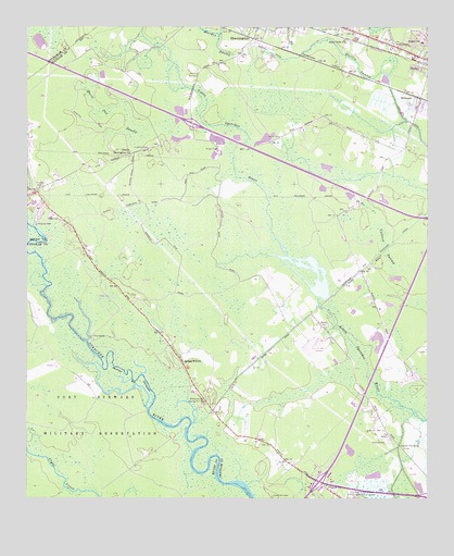
Meldrim SE, GA USGS Topographic Map
Click on map above to begin viewing in our Map Viewer.

This topographic map contains these locations and features:
Feature Name Type Latitude Longitude GNIS ID View Map
Ash Street Baptist ChurchChurchN32.1239°W81.2964°2502722View Map
Bethel CemeteryCemeteryN32.0466°W81.2804°311148View Map
Bethel ChurchChurchN32.0458°W81.2823°1694456View Map
Bethel School (historical)SchoolN32.0455°W81.2815°1694457View Map
Brickyard CemeteryCemeteryN32.0263°W81.3182°311781View Map
Calvary Assembly of God ChurchChurchN32.1197°W81.2634°2502912View Map
City of BloomingdaleCivilN32.1250°W81.3077°2403880View Map
City of PoolerCivilN32.1024°W81.2539°2404550View Map
Elkins CemeteryCemeteryN32.0738°W81.3643°313907View Map
Ennis CemeteryCemeteryN32.0960°W81.2957°313957View Map
Exit 16CrossingN32.0047°W81.2834°1694502View Map
Exit 31CrossingN32.0996°W81.3234°1694506View Map
Fort Argyle ChurchChurchN32.0306°W81.3234°2502633View Map
Garden Acres EstatesPopulated PlaceN32.1035°W81.2507°1694528View Map
Gravel Hill CemeteryCemeteryN32.1245°W81.2804°314789View Map
Hardin CanalCanalN32.1008°W81.2568°315119View Map
Heavenbound Baptist ChurchChurchN32.0381°W81.2584°2502644View Map
HendersonPopulated PlaceN32.0081°W81.2589°2633172View Map
Henderson Census Designated PlaceCensusN32.0102°W81.2656°2583404View Map
Highland Woods Mobile Home ParkPopulated PlaceN32.0350°W81.2513°2502516View Map
Holy Angels ChurchChurchN32.1008°W81.2823°1694556View Map
Hopeton Plantation CemeteryCemeteryN32.0135°W81.2573°315637View Map
Hopeton Plantation Field (historical)AirportN32.0347°W81.2629°351898View Map
Horning MemorialCemeteryN32.1135°W81.3223°315675View Map
Horse Pen SwampSwampN32.0973°W81.3474°315701View Map
Little Ogeechee PondReservoirN32.0588°W81.2893°1694585View Map
Morgans Trailer Park EastsidePopulated PlaceN32.1075°W81.3249°2502524View Map
Pilgrim ChurchChurchN32.0027°W81.2809°320520View Map
Pooler - Bloomingdale Region Water Pollution Control PlantLocaleN32.1127°W81.2643°2502463View Map
Pooler Elementary SchoolSchoolN32.1212°W81.2520°321007View Map
Pooler Police DepartmentBuildingN32.1159°W81.2500°2733613View Map
Pooler Post OfficePost OfficeN32.1230°W81.2653°2502491View Map
Pooler-Bloomingdale DivisionCivilN32.0473°W81.2742°1936474View Map
Regency Mobile Home ParkPopulated PlaceN32.0321°W81.2560°2502534View Map
Saint John ChurchChurchN32.1216°W81.2746°322097View Map
Saint Paul Church (historical)ChurchN32.1177°W81.2587°1694645View Map
Sand Hill CemeteryCemeteryN32.0008°W81.2979°322419View Map
Savannah Festival ShopsLocaleN32.0006°W81.2844°2502080View Map
South Newington ChurchChurchN32.0916°W81.3421°323263View Map
Southside Church of GodChurchN32.0063°W81.2518°2502839View Map
Southside Fire Department Station 11BuildingN32.0519°W81.3429°2603901View Map
Southwest Baptist ChurchChurchN32.0245°W81.2677°2502840View Map
Southwest Elementary SchoolSchoolN32.0001°W81.2615°2453151View Map
Spring Hill ChurchChurchN32.0363°W81.3259°323418View Map
TutensPopulated PlaceN32.1052°W81.2537°1694690View Map
WAEV-FM (Savannah)TowerN32.0585°W81.3387°352775View Map
WCHY-FM (Savannah)TowerN32.0541°W81.3501°352771View Map
WEAS-FM (Savannah)TowerN32.0469°W81.3407°352772View Map
West Chatham Elementary SchoolSchoolN32.0948°W81.2624°2120317View Map
West Chatham Middle SchoolSchoolN32.0937°W81.2591°2120316View Map
WilliamsPopulated PlaceN32.1063°W81.2521°325322View Map
WIXV-FM (Savannah)TowerN32.0585°W81.3387°352776View Map
WJCL-FM (Savannah)TowerN32.0585°W81.3387°352773View Map
WJCL-TV (Savannah)TowerN32.0585°W81.3387°352867View Map
Wright CemeteryCemeteryN32.0927°W81.3146°325570View Map
WSAV-TV (Savannah)TowerN32.0591°W81.2990°352866View Map
WSVH-FM (Savannah)TowerN32.0591°W81.2990°352770View Map
WTOC-TV (Savannah)TowerN32.0541°W81.3501°352865View Map
WYFS-FM (Savannah)TowerN32.0680°W81.3546°352777View Map
WZAT-FM (Savannah)TowerN32.0585°W81.3387°352774View Map

Note: Coordinates in the location and feature list above are referenced to NAD83 datum.


Copyright (C) 2008-2024 Ryan Niemi / Sunset Dynamics ... All Rights Reserved