TopoQuest Logo
Do you find TopoQuest useful?
Help keep TopoQuest running and adding new maps/features by donating!
Bitcoin:  19c7KJd3qBynnjoSw5npx9KScwjBe4ifkT
Litecoin:  LXs6TkuXGGXo1vDsWCkWVdjQX94eUKd6ui
Home View Maps Find Maps Find Places Resources & Links


Mescal, Arizona Topographic Map

USGS Map Title: Mescal, AZ
USGS Map MRC: 31110H4
DRG (GeoTIFF) Download: o31110h4.tif


Neighboring USGS Topographic Map Quads:


  Rincon Peak, AZ  
32110A5
 

  Galleta Flat West, AZ  
32110A4
 

  Galleta Flat East, AZ  
32110A3
 

  The Narrows, AZ  
31110H5
 

  Mescal, AZ  
31110H4
 

  Benson, AZ  
31110H3
 

  Spring Water Canyon, AZ  
31110G5
 

  Apache Peak, AZ  
31110G4
 

  McGrew Spring, AZ  
31110G3


Map MRC Location:

N32°
W111°
N32°
W110°
H8 H7 H6 H5 H4 H3 H2 H1
G8 G7 G6 G5 G4 G3 G2 G1
F8 F7 F6 F5 F4 F3 F2 F1
E8 E7 E6 E5 E4 E3 E2 E1
D8 D7 D6 D5 D4 D3 D2 D1
C8 C7 C6 C5 C4 C3 C2 C1
B8 B7 B6 B5 B4 B3 B2 B1
A8 A7 A6 A5 A4 A3 A2 A1
N31°
W111°
N31°
W110°

Mescal, AZ USGS 1:24K Topographic Map Preview:
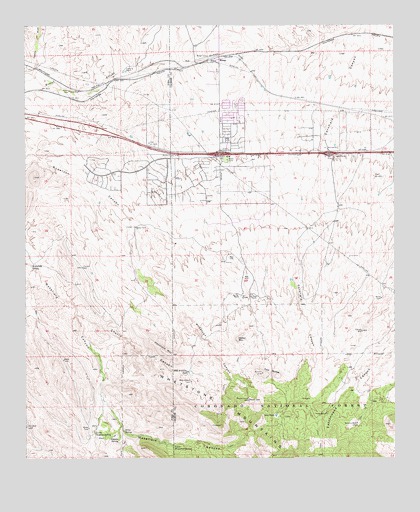
Mescal, AZ USGS Topographic Map
Click on map above to begin viewing in our Map Viewer.

This topographic map contains these locations and features:
Feature Name Type Latitude Longitude GNIS ID View Map
B Smith RanchLocaleN31.9470°W110.3948°41846View Map
Bill Williams TankReservoirN31.9001°W110.4455°26334View Map
Canary WellWellN31.9118°W110.3867°39198View Map
Cherry CanyonValleyN31.9162°W110.4834°27539View Map
Church of ChristChurchN31.9536°W110.4351°2623394View Map
Community Bible ChurchChurchN31.9554°W110.4354°2623404View Map
Crystal WellWellN31.9301°W110.4812°28204View Map
Crystal WellWellN31.9304°W110.4809°37259View Map
Cumaro WashStreamN31.9859°W110.4979°28211View Map
Dead Cow SpringSpringN31.8964°W110.4319°2680298View Map
Dirt TankReservoirN31.8875°W110.4158°28484View Map
Dolphin WellWellN31.8845°W110.3887°28528View Map
Double X RanchLocaleN31.9870°W110.4670°28571View Map
Easter MountainSummitN31.9093°W110.4290°28800View Map
Forest WellWellN31.9142°W110.4125°2680307View Map
Haystack MountainSummitN31.9084°W110.4579°29814View Map
Jason WellWellN31.9021°W110.4312°2680297View Map
Jay Six RanchLocaleN31.9218°W110.4284°30513View Map
KAVV-FM (Benson)TowerN31.9054°W110.4529°45573View Map
KAVV-FM (Sierra Vista)TowerN31.9223°W110.3770°43442View Map
Little Nogales SpringSpringN31.8823°W110.4770°37372View Map
Lower Walkerfield SpringSpringN31.8781°W110.4506°31385View Map
MescalPopulated PlaceN31.9901°W110.4354°31744View Map
Mescal - J6 Fire DistrictBuildingN31.9723°W110.4339°2622552View Map
Mescal Census Designated PlaceCensusN31.9674°W110.4367°2582826View Map
Mescal InterchangeCrossingN31.9629°W110.4348°31749View Map
Naegle WellWellN31.8962°W110.3756°8478View Map
New West SchoolSchoolN31.9652°W110.4324°2544777View Map
Nogales SpringSpringN31.8804°W110.4692°32337View Map
North TankReservoirN31.8981°W110.3945°2680304View Map
Peace in the Valley Lutheran ChurchChurchN31.9553°W110.4336°2623213View Map
Pimaco TwoPopulated PlaceN31.9506°W110.4526°45015View Map
Pimaco Two Census Designated PlaceCensusN31.9666°W110.4663°2582841View Map
Round CorralLocaleN31.8920°W110.4248°33819View Map
Silver SpringSpringN31.8829°W110.4673°34446View Map
Skyline InterchangeCrossingN31.9631°W110.3976°34514View Map
Trask WellWellN31.8876°W110.3995°35452View Map
Twin ButtesSummitN31.8995°W110.4204°35613View Map
Wakefield SpringSpringN31.9306°W110.4985°35812View Map
West WellWellN31.9812°W110.4856°36028View Map
Wildcat WellWellN31.8970°W110.4445°36193View Map
Williams RanchLocaleN31.9215°W110.4245°36215View Map
Williams WellWellN31.9031°W110.4044°2680301View Map

Note: Coordinates in the location and feature list above are referenced to NAD83 datum.


Copyright (C) 2008-2024 Ryan Niemi / Sunset Dynamics ... All Rights Reserved