TopoQuest Logo
Do you find TopoQuest useful?
Help keep TopoQuest running and adding new maps/features by donating!
Bitcoin:  19c7KJd3qBynnjoSw5npx9KScwjBe4ifkT
Litecoin:  LXs6TkuXGGXo1vDsWCkWVdjQX94eUKd6ui
Home View Maps Find Maps Find Places Resources & Links


Middle Grove, New York Topographic Map

USGS Map Title: Middle Grove, NY
USGS Map MRC: 43073A8
DRG (GeoTIFF) Download: o43073a8.tif


Neighboring USGS Topographic Map Quads:


  Edinburg, NY  
43074B1
 

  Porter Corners, NY  
43073B8
 

  Corinth, NY  
43073B7
 

  Galway, NY  
43074A1
 

  Middle Grove, NY  
43073A8
 

  Saratoga Springs, NY  
43073A7
 

  Pattersonville, NY  
42074H1
 

  Burnt Hills, NY  
42073H8
 

  Round Lake, NY  
42073H7


Map MRC Location:

N44°
W74°
N44°
W73°
H8 H7 H6 H5 H4 H3 H2 H1
G8 G7 G6 G5 G4 G3 G2 G1
F8 F7 F6 F5 F4 F3 F2 F1
E8 E7 E6 E5 E4 E3 E2 E1
D8 D7 D6 D5 D4 D3 D2 D1
C8 C7 C6 C5 C4 C3 C2 C1
B8 B7 B6 B5 B4 B3 B2 B1
A8 A7 A6 A5 A4 A3 A2 A1
N43°
W74°
N43°
W73°

Middle Grove, NY USGS 1:24K Topographic Map Preview:
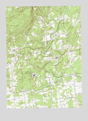
Middle Grove, NY USGS Topographic Map
Click on map above to begin viewing in our Map Viewer.

This topographic map contains these locations and features:
Feature Name Type Latitude Longitude GNIS ID View Map
Ashley CemeteryCemeteryN43.0233°W73.9736°2424899View Map
Baptist HillSummitN43.0626°W73.9807°942974View Map
BirchtonPopulated PlaceN43.0009°W73.9682°944014View Map
Blue BrookStreamN43.1170°W73.9007°944300View Map
Chatfield CornerPopulated PlaceN43.1081°W73.9426°946447View Map
Christ the Saviour Orthodox Church of Saratoga CountyChurchN43.0288°W73.9251°2615723View Map
Clover Mill CreekStreamN43.0659°W73.9371°946933View Map
Cornell Howard CemeteryCemeteryN43.0849°W73.8974°2424898View Map
Country Brook FarmLocaleN43.0672°W73.9442°2519108View Map
Crook BrookStreamN43.0501°W73.9362°947772View Map
East GalwayPopulated PlaceN43.0717°W73.9885°949078View Map
East Galway CemeteryCemeteryN43.0671°W73.9851°2424914View Map
Frink - Hoyt CemeteryCemeteryN43.0812°W73.9368°2424905View Map
Frink BrookStreamN43.0754°W73.9290°950739View Map
Frink CornerPopulated PlaceN43.0817°W73.9365°972517View Map
Galway Ambulance CorpsBuildingN43.0211°W73.9713°2720149View Map
Galway Country ClubLocaleN43.0462°W73.9915°974387View Map
Gasher BrookStreamN43.1065°W73.9098°950931View Map
Glowegee CreekStreamN43.0379°W73.9112°951266View Map
Grace Brethren ChurchChurchN43.0340°W73.9283°2616111View Map
Grenell Road CemeteryCemeteryN43.0670°W73.9559°2424909View Map
Hatch BridgeBridgeN43.0670°W73.9360°952352View Map
HyspotSummitN43.0992°W73.8915°953570View Map
Johnstons WineryBuildingN43.0156°W73.9686°2519112View Map
Middle GrovePopulated PlaceN43.0898°W73.9179°957104View Map
Middle Grove CemeteryCemeteryN43.0909°W73.9135°2424913View Map
Middle Grove Fire CompanyBuildingN43.0913°W73.9161°2718388View Map
Middle Grove United Methodist ChurchChurchN43.0903°W73.9164°2616718View Map
Milton CenterPopulated PlaceN43.0409°W73.8898°957367View Map
Milton Fire District 1 Rock City Falls Volunteer Fire Company Rock City Falls Station 1BuildingN43.0611°W73.9173°2718428View Map
North MiltonPopulated PlaceN43.0698°W73.8943°958857View Map
Oakwood CemeteryCemeteryN43.0339°W73.8862°2424910View Map
Old Stone ChurchChurchN43.0702°W73.8775°2616168View Map
Pages CornerPopulated PlaceN43.0904°W73.9010°959756View Map
Partridge Run FarmLocaleN43.0242°W73.9878°2519126View Map
Peacock BrookStreamN43.1212°W73.8993°970464View Map
Pine Meadow FarmLocaleN43.0239°W73.9031°2543430View Map
Pioneer Hills Golf CourseLocaleN43.0170°W73.9545°2615456View Map
Rock City FallsPopulated PlaceN43.0620°W73.9171°962699View Map
Rock City Falls CemeteryCemeteryN43.0492°W73.9182°2424904View Map
Rock City Falls Post OfficePost OfficeN43.0645°W73.9190°2618091View Map
Rock City Falls United Methodist ChurchChurchN43.0580°W73.9163°2616848View Map
Rose BrookStreamN43.1217°W73.9696°962900View Map
Saint Paul's ChurchChurchN43.0647°W73.9200°2617002View Map
Sampler FarmLocaleN43.0167°W73.9103°2519150View Map
Simpson United Methodist ChurchChurchN43.0574°W73.9172°2616265View Map
South Galway CornerPopulated PlaceN43.0206°W73.9715°965749View Map
South Milton CemeteryCemeteryN43.0003°W73.9079°2424911View Map
Star BrookStreamN43.0567°W73.9126°966240View Map
Town of MiltonCivilN43.0406°W73.8998°979221View Map
United States Reservation Knolls Atomic Energy PlantLocaleN43.0406°W73.9537°975710View Map
West CornersPopulated PlaceN43.0198°W73.9885°969187View Map
West MiltonPopulated PlaceN43.0376°W73.9293°970802View Map
West Milton CemeteryCemeteryN43.0272°W73.9287°2424912View Map
Winterwood FarmLocaleN43.0153°W73.8839°2515556View Map

Note: Coordinates in the location and feature list above are referenced to NAD83 datum.


Copyright (C) 2008-2025 Ryan Niemi / Sunset Dynamics ... All Rights Reserved