TopoQuest Logo
Do you find TopoQuest useful?
Help keep TopoQuest running and adding new maps/features by donating!
Bitcoin:  19c7KJd3qBynnjoSw5npx9KScwjBe4ifkT
Litecoin:  LXs6TkuXGGXo1vDsWCkWVdjQX94eUKd6ui
Home View Maps Find Maps Find Places Resources & Links


Aguilar, Colorado Topographic Map

USGS Map Title: Aguilar, CO
USGS Map MRC: 37104D6
DRG (GeoTIFF) Download: o37104d6.tif


Neighboring USGS Topographic Map Quads:


  Walsenburg South, CO  
37104E7
 

  Pryor, CO  
37104E6
 

  Pryor SE, CO  
37104E5
 

  Santa Clara, CO  
37104D7
 

  Aguilar, CO  
37104D6
 

  The Hogback, CO  
37104D5
 

  Gulnare, CO  
37104C7
 

  Delagua, CO  
37104C6
 

  Ludlow, CO  
37104C5


Map MRC Location:

N38°
W105°
N38°
W104°
H8 H7 H6 H5 H4 H3 H2 H1
G8 G7 G6 G5 G4 G3 G2 G1
F8 F7 F6 F5 F4 F3 F2 F1
E8 E7 E6 E5 E4 E3 E2 E1
D8 D7 D6 D5 D4 D3 D2 D1
C8 C7 C6 C5 C4 C3 C2 C1
B8 B7 B6 B5 B4 B3 B2 B1
A8 A7 A6 A5 A4 A3 A2 A1
N37°
W105°
N37°
W104°

Aguilar, CO USGS 1:24K Topographic Map Preview:
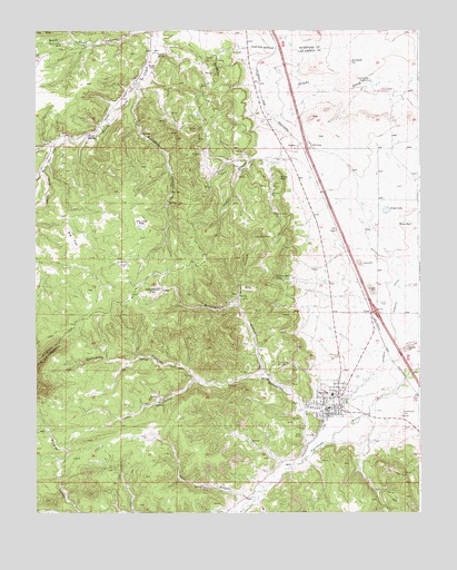
Aguilar, CO USGS Topographic Map
Click on map above to begin viewing in our Map Viewer.

This topographic map contains these locations and features:
Feature Name Type Latitude Longitude GNIS ID View Map
Adobe CanyonValleyN37.4096°W104.6980°194460View Map
AguilarPopulated PlaceN37.4028°W104.6533°194464View Map
Aguilar Post OfficePost OfficeN37.4016°W104.6553°2750926View Map
Big FlatFlatN37.4458°W104.7380°194446View Map
Black Hawk MineMineN37.4970°W104.7408°194434View Map
Blazing Rag MineMineN37.3967°W104.6619°1735172View Map
Borrego DitchCanalN37.4172°W104.6339°203725View Map
Broadhead MineMineN37.4156°W104.6839°1735173View Map
Brodhead CanyonValleyN37.4108°W104.6764°194456View Map
Bunker HillSummitN37.4895°W104.6910°194438View Map
Bunker Hill Number One MineMineN37.4931°W104.6950°1735167View Map
Daisy CanyonValleyN37.3788°W104.6820°194461View Map
Daisy MineMineN37.3817°W104.6961°194459View Map
Dry Lake FlatFlatN37.4500°W104.7158°194444View Map
Empire MineMineN37.4056°W104.6669°1735176View Map
Fourmile CanyonValleyN37.4853°W104.7167°194452View Map
Gem MineMineN37.3953°W104.6639°194465View Map
Goat Ranch FlatFlatN37.4325°W104.7105°194445View Map
Gonzales CanyonValleyN37.4029°W104.6556°194466View Map
Gonzales DitchCanalN37.3947°W104.6589°194468View Map
Green CanyonValleyN37.4284°W104.6841°194451View Map
Green Canyon MinesMineN37.4242°W104.6880°1735177View Map
Healy Strip MineMineN37.4036°W104.6525°1735187View Map
Homestead WindmillLocaleN37.4870°W104.6414°194442View Map
Jewel MineMineN37.4153°W104.6825°1735171View Map
Jolly PitMineN37.4325°W104.6411°1735178View Map
Kenneth MineMineN37.4570°W104.6853°1735179View Map
Kirkland PitReservoirN37.4920°W104.6473°194441View Map
Las Animas County Sheriff's OfficeBuildingN37.4018°W104.6559°2757325View Map
Las Animas Number Nine MineMineN37.4289°W104.6864°1735180View Map
LynnPopulated PlaceN37.4272°W104.6411°194433View Map
Lynn Census Designated PlaceCensusN37.4219°W104.6431°2583261View Map
New Rouse MineMineN37.4931°W104.7144°1735169View Map
North Santa Clara CreekStreamN37.4706°W104.7439°194397View Map
Old Number Three MineMineN37.4250°W104.6842°1735181View Map
Old Wichita MineMineN37.4603°W104.6764°1735182View Map
Peerless MineMineN37.4017°W104.6639°1735170View Map
Poma LakeLakeN37.4534°W104.6358°194454View Map
Poma ReservoirReservoirN37.4497°W104.6279°194455View Map
Prosperity MineMineN37.4136°W104.6678°1735183View Map
Prosperity Mine Number 2MineN37.4133°W104.6678°194458View Map
Rapson MineMineN37.4525°W104.6722°194448View Map
RousePopulated PlaceN37.4908°W104.7117°194436View Map
Rouse MineMineN37.4936°W104.7075°194439View Map
Rouse SpringSpringN37.4728°W104.7328°194435View Map
Royal MineMineN37.4122°W104.6764°194457View Map
Royal MineMineN37.4122°W104.7094°1735197View Map
RugbyPopulated PlaceN37.4700°W104.6650°194440View Map
Rugby CanyonValleyN37.4671°W104.6765°194453View Map
Rugby RockSummitN37.4618°W104.6703°194437View Map
Saint Anthony CemeteryCemeteryN37.4007°W104.6311°194463View Map
Sawmill FlatFlatN37.4395°W104.7219°194447View Map
South Santa Clara CreekStreamN37.4706°W104.7439°194430View Map
Southwestern MineMineN37.4358°W104.6722°194449View Map
Spanish Peaks Volunteer Fire Department Aguilar StationBuildingN37.4014°W104.6569°2666909View Map
Spring CanyonValleyN37.4632°W104.7478°194432View Map
Spring MineMineN37.4311°W104.6844°194450View Map
T V HillSummitN37.3844°W104.6313°194462View Map
Town of AguilarCivilN37.4036°W104.6550°2412339View Map
Vickers MineMineN37.4664°W104.6861°1735220View Map
Victor Smith ProspectMineN37.4461°W104.6772°1735185View Map
Weeks MineMineN37.4283°W104.6725°1735186View Map

Note: Coordinates in the location and feature list above are referenced to NAD83 datum.


Copyright (C) 2008-2024 Ryan Niemi / Sunset Dynamics ... All Rights Reserved