TopoQuest Logo
Do you find TopoQuest useful?
Help keep TopoQuest running and adding new maps/features by donating!
Bitcoin:  19c7KJd3qBynnjoSw5npx9KScwjBe4ifkT
Litecoin:  LXs6TkuXGGXo1vDsWCkWVdjQX94eUKd6ui
Home View Maps Find Maps Find Places Resources & Links


Delagua, Colorado Topographic Map

USGS Map Title: Delagua, CO
USGS Map MRC: 37104C6
DRG (GeoTIFF) Download: o37104c6.tif


Neighboring USGS Topographic Map Quads:


  Santa Clara, CO  
37104D7
 

  Aguilar, CO  
37104D6
 

  The Hogback, CO  
37104D5
 

  Gulnare, CO  
37104C7
 

  Delagua, CO  
37104C6
 

  Ludlow, CO  
37104C5
 

  Weston, CO  
37104B7
 

  Madrid, CO  
37104B6
 

  Trinidad West, CO  
37104B5


Map MRC Location:

N38°
W105°
N38°
W104°
H8 H7 H6 H5 H4 H3 H2 H1
G8 G7 G6 G5 G4 G3 G2 G1
F8 F7 F6 F5 F4 F3 F2 F1
E8 E7 E6 E5 E4 E3 E2 E1
D8 D7 D6 D5 D4 D3 D2 D1
C8 C7 C6 C5 C4 C3 C2 C1
B8 B7 B6 B5 B4 B3 B2 B1
A8 A7 A6 A5 A4 A3 A2 A1
N37°
W105°
N37°
W104°

Delagua, CO USGS 1:24K Topographic Map Preview:
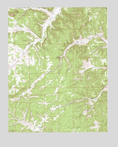
Delagua, CO USGS Topographic Map
Click on map above to begin viewing in our Map Viewer.

This topographic map contains these locations and features:
Feature Name Type Latitude Longitude GNIS ID View Map
Albertson CemeteryCemeteryN37.2753°W104.6830°194535View Map
Bald KnobsSummitN37.2514°W104.7444°194532View Map
Bear Canon MinesMineN37.2847°W104.6486°1735188View Map
Bear CanyonValleyN37.2803°W104.6477°194536View Map
Bear Canyon MineMineN37.2820°W104.6419°194541View Map
Bear Canyon SpringSpringN37.2711°W104.6483°194539View Map
Canyon BonitoValleyN37.3268°W104.6794°194544View Map
Canyon Del Agua SpringSpringN37.3245°W104.6842°194545View Map
Castro CanyonValleyN37.3379°W104.7172°194550View Map
Delagua (historical)Populated PlaceN37.3400°W104.6630°194549View Map
Delagua and Delagua MinesMineN37.3611°W104.6505°1735175View Map
Frio CanyonValleyN37.3141°W104.7495°194525View Map
Gregg CanyonValleyN37.2579°W104.7296°194529View Map
Hunter CanyonValleyN37.2766°W104.6778°194534View Map
Mauricio CanyonValleyN37.3687°W104.6928°194398View Map
Mitotes CanyonValleyN37.3308°W104.7299°194526View Map
Munoz CanyonValleyN37.3459°W104.7029°194552View Map
Prairie Canon MinesMineN37.2792°W104.6486°1735189View Map
Prairie CanyonValleyN37.2826°W104.6454°194537View Map
Prairie Canyon MineMineN37.2747°W104.6486°1735213View Map
Prairie Dog FlatFlatN37.2703°W104.6644°194538View Map
Reilly CanyonPopulated PlaceN37.2545°W104.7100°194531View Map
Scott CanyonValleyN37.2515°W104.7123°194530View Map
Three Pines Number One MineMineN37.2833°W104.6511°1735190View Map
Toller MineMineN37.2908°W104.6394°1735219View Map
Trinidad Basin Strip MineMineN37.3450°W104.6586°1735191View Map
Trujillo CanyonValleyN37.3432°W104.7102°194527View Map
Trujillo CreekStreamN37.3464°W104.7044°194528View Map
Trujillo Creek CemeteryCemeteryN37.3567°W104.7371°194553View Map
Ute CanyonValleyN37.2840°W104.6507°194542View Map
VallorsoPopulated PlaceN37.2828°W104.6450°194540View Map
Wheeler CanyonValleyN37.3746°W104.7351°194467View Map
Williams CanyonValleyN37.3407°W104.7087°194551View Map

Note: Coordinates in the location and feature list above are referenced to NAD83 datum.


Copyright (C) 2008-2025 Ryan Niemi / Sunset Dynamics ... All Rights Reserved