TopoQuest Logo
Do you find TopoQuest useful?
Help keep TopoQuest running and adding new maps/features by donating!
Bitcoin:  19c7KJd3qBynnjoSw5npx9KScwjBe4ifkT
Litecoin:  LXs6TkuXGGXo1vDsWCkWVdjQX94eUKd6ui
Home View Maps Find Maps Find Places Resources & Links


Middlesex, New York Topographic Map

USGS Map Title: Middlesex, NY
USGS Map MRC: 42077F3
DRG (GeoTIFF) Download: o42077f3.tif


Neighboring USGS Topographic Map Quads:


  Bristol Center, NY  
42077G4
 

  Canandaigua Lake, NY  
42077G3
 

  Rushville, NY  
42077G2
 

  Bristol Springs, NY  
42077F4
 

  Middlesex, NY  
42077F3
 

  Potter, NY  
42077F2
 

  Naples, NY  
42077E4
 

  Prattsburg, NY  
42077E3
 

  Pulteney, NY  
42077E2


Map MRC Location:

N43°
W78°
N43°
W77°
H8 H7 H6 H5 H4 H3 H2 H1
G8 G7 G6 G5 G4 G3 G2 G1
F8 F7 F6 F5 F4 F3 F2 F1
E8 E7 E6 E5 E4 E3 E2 E1
D8 D7 D6 D5 D4 D3 D2 D1
C8 C7 C6 C5 C4 C3 C2 C1
B8 B7 B6 B5 B4 B3 B2 B1
A8 A7 A6 A5 A4 A3 A2 A1
N42°
W78°
N42°
W77°

Middlesex, NY USGS 1:24K Topographic Map Preview:
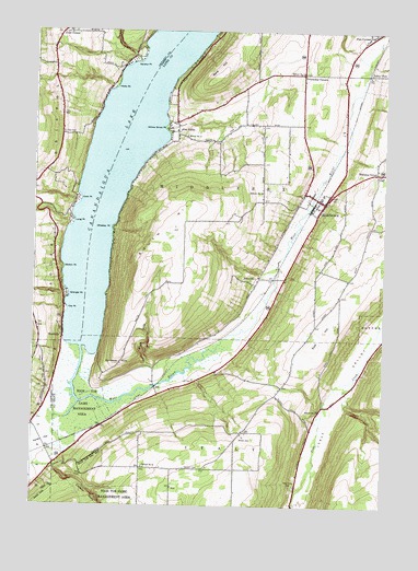
Middlesex, NY USGS Topographic Map
Click on map above to begin viewing in our Map Viewer.

This topographic map contains these locations and features:
Feature Name Type Latitude Longitude GNIS ID View Map
Bare HillSummitN42.7370°W77.3128°942999View Map
Clark GullyValleyN42.6620°W77.3333°946757View Map
Conklin GullyValleyN42.6351°W77.3670°947292View Map
Cook PointCapeN42.7056°W77.3589°947351View Map
Corey GullyValleyN42.7451°W77.2614°970035View Map
Covel CornerPopulated PlaceN42.7495°W77.3633°972346View Map
Coy PointCapeN42.6767°W77.3630°947615View Map
Coye CemeteryCemeteryN42.7231°W77.3651°947617View Map
East HillSummitN42.6712°W77.2711°949117View Map
Granger PointCapeN42.6806°W77.3622°951498View Map
Hicks PointCapeN42.7356°W77.3467°952702View Map
Indian Village Recreational Vehicle ParkLocaleN42.7252°W77.3228°2615211View Map
Italy Valley CemeteryCemeteryN42.6304°W77.2811°953852View Map
Johnson CemeteryCemeteryN42.6350°W77.3204°954107View Map
Long PointCapeN42.7001°W77.3614°955891View Map
Majestic Hills Golf CourseLocaleN42.6513°W77.2966°2615433View Map
MiddlesexPopulated PlaceN42.7048°W77.2716°957152View Map
Middlesex Baptist ChurchChurchN42.7075°W77.2790°2616719View Map
Middlesex CemeteryCemeteryN42.7052°W77.2705°2514509View Map
Middlesex Hose CompanyBuildingN42.7045°W77.2726°2701185View Map
Middlesex Post OfficePost OfficeN42.7047°W77.2713°2618022View Map
Middlesex Town HallBuildingN42.7047°W77.2720°2617646View Map
Middlesex United Methodist ChurchChurchN42.7071°W77.2698°2616720View Map
Middlesex Valley AirportAirportN42.7126°W77.2729°2443089View Map
Middlesex Valley Volunteer Ambulance ServiceBuildingN42.7223°W77.2639°2735516View Map
Middlesex Valley Volunteer Ambulance ServiceBuildingN42.7223°W77.2639°2719231View Map
Naples CreekStreamN42.6520°W77.3583°958259View Map
Overacker CornersLocaleN42.7390°W77.2797°959655View Map
Overackers CemeteryCemeteryN42.7412°W77.2791°2514510View Map
Parish FlatFlatN42.6415°W77.3705°959865View Map
Pine CornersPopulated PlaceN42.7492°W77.2566°960427View Map
Pine Corners CemeteryCemeteryN42.7496°W77.2544°2514511View Map
School Number 2 (historical)SchoolN42.6503°W77.2728°975177View Map
School Number 3 (historical)SchoolN42.7395°W77.2803°975263View Map
School Number 4 (historical)SchoolN42.7223°W77.3214°975342View Map
School Number 5 (historical)SchoolN42.7078°W77.2944°975413View Map
School Number 6 (historical)SchoolN42.6353°W77.3350°975473View Map
School Number 7 (historical)SchoolN42.6853°W77.2950°975534View Map
Seneca PointCapeN42.7428°W77.3392°964836View Map
Seneca Point GullyValleyN42.7442°W77.3408°964837View Map
South HillSummitN42.6984°W77.3250°965779View Map
Sunnyside PointRidgeN42.6617°W77.3458°966818View Map
Town of MiddlesexCivilN42.7134°W77.2909°979215View Map
Valley ViewPopulated PlaceN42.7392°W77.2558°973186View Map
Vine ValleyPopulated PlaceN42.7237°W77.3247°973192View Map
Vine Valley FarmLocaleN42.7406°W77.2881°2547264View Map
Vine Valley United Methodist ChurchChurchN42.7238°W77.3246°2617169View Map
Walton PointCapeN42.6878°W77.3644°968742View Map
West RiverStreamN42.6665°W77.3578°970855View Map
West River CemeteryCemeteryN42.6581°W77.3175°2514553View Map
Whiskey PointCapeN42.6984°W77.3472°971056View Map
Williams CornerPopulated PlaceN42.7128°W77.2533°973271View Map
Willow Grove PointCapeN42.7245°W77.3289°971359View Map
Wolven CemeteryCemeteryN42.6434°W77.2994°971588View Map
WoodvillePopulated PlaceN42.6698°W77.3642°971725View Map

Note: Coordinates in the location and feature list above are referenced to NAD83 datum.


Copyright (C) 2008-2024 Ryan Niemi / Sunset Dynamics ... All Rights Reserved