TopoQuest Logo
Do you find TopoQuest useful?
Help keep TopoQuest running and adding new maps/features by donating!
Bitcoin:  19c7KJd3qBynnjoSw5npx9KScwjBe4ifkT
Litecoin:  LXs6TkuXGGXo1vDsWCkWVdjQX94eUKd6ui
Home View Maps Find Maps Find Places Resources & Links


Minden South, Nebraska Topographic Map

USGS Map Title: Minden South, NE
USGS Map MRC: 40098D8
DRG (GeoTIFF) Download: o40098d8.tif


Neighboring USGS Topographic Map Quads:


  Kearney SE, NE  
40099E1
 

  Minden North, NE  
40098E8
 

  Heartwell, NE  
40098E7
 

  Axtell East, NE  
40099D1
 

  Minden South, NE  
40098D8
 

  Norman, NE  
40098D7
 

  Hildreth, NE  
40099C1
 

  Upland, NE  
40098C8
 

  Upland SE, NE  
40098C7


Map MRC Location:

N41°
W99°
N41°
W98°
H8 H7 H6 H5 H4 H3 H2 H1
G8 G7 G6 G5 G4 G3 G2 G1
F8 F7 F6 F5 F4 F3 F2 F1
E8 E7 E6 E5 E4 E3 E2 E1
D8 D7 D6 D5 D4 D3 D2 D1
C8 C7 C6 C5 C4 C3 C2 C1
B8 B7 B6 B5 B4 B3 B2 B1
A8 A7 A6 A5 A4 A3 A2 A1
N40°
W99°
N40°
W98°

Minden South, NE USGS 1:24K Topographic Map Preview:
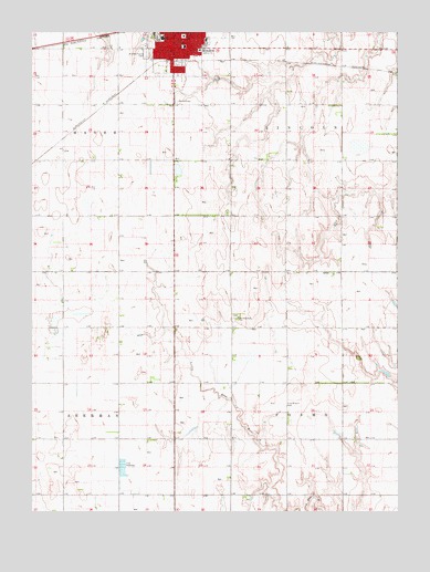
Minden South, NE USGS Topographic Map
Click on map above to begin viewing in our Map Viewer.

This topographic map contains these locations and features:
Feature Name Type Latitude Longitude GNIS ID View Map
Bethany Lutheran ChurchChurchN40.4983°W98.9467°1873831View Map
C L Jones Middle SchoolSchoolN40.4983°W98.9573°1873841View Map
City of MindenCivilN40.4980°W98.9675°2395341View Map
Countryside Mobile Home ParkPopulated PlaceN40.4986°W98.9479°1873826View Map
First Christian ChurchChurchN40.4992°W98.9512°1873833View Map
Fredericksburg Post Office (historical)Post OfficeN40.4250°W98.9295°1873802View Map
Fredricksburg ChurchChurchN40.4256°W98.9301°829401View Map
Free Mission CemeteryCemeteryN40.4031°W98.9142°829403View Map
Hubert DamDamN40.4880°W98.9361°1767576View Map
Hubert ReservoirReservoirN40.4877°W98.9373°1767577View Map
Jensen Memorial LibraryBuildingN40.4992°W98.9459°1873844View Map
Kearney County CourthouseBuildingN40.4992°W98.9484°1873845View Map
Kearney County Emergency Management AgencyBuildingN40.4974°W98.9487°2553786View Map
Kearney County Health ServicesHospitalN40.4955°W98.9426°1873843View Map
Kearney County Sheriff OfficeBuildingN40.4972°W98.9484°1873839View Map
MindenPopulated PlaceN40.4986°W98.9479°831340View Map
Minden Dental ClinicHospitalN40.4950°W98.9509°1873848View Map
Minden East Elementary SchoolSchoolN40.4961°W98.9481°1873840View Map
Minden Eye ClinicHospitalN40.4950°W98.9509°1873847View Map
Minden High SchoolSchoolN40.4983°W98.9556°1873842View Map
Minden Medical ClinicHospitalN40.4975°W98.9473°1873824View Map
Minden Police DepartmentBuildingN40.4974°W98.9489°1873838View Map
Minden Post OfficePost OfficeN40.4988°W98.9474°1873829View Map
Minden Prairie CemeteryCemeteryN40.4942°W98.9615°831341View Map
Minden Volunteer Fire DepartmentBuildingN40.4979°W98.9496°2553335View Map
Northeast Sacramento State Wildlife Management AreaParkN40.4250°W98.9906°1873821View Map
Saint Paul Lutheran ChurchChurchN40.4970°W98.9487°1873835View Map
South Side Mobile Home CourtPopulated PlaceN40.4986°W98.9479°1873827View Map
Township of CosmoCivilN40.3939°W98.8947°837939View Map
Township of LincolnCivilN40.4810°W98.8949°838095View Map
United Methodist ChurchChurchN40.4981°W98.9406°1873836View Map
Warp DamDamN40.4105°W98.8780°1767578View Map
Warp ReservoirReservoirN40.4119°W98.8807°1767579View Map
Westminster United Presbyterian ChurchChurchN40.4958°W98.9492°1873837View Map
Willowbrook Center for Mental Health and WellnessHospitalN40.4986°W98.9479°1873825View Map

Note: Coordinates in the location and feature list above are referenced to NAD83 datum.


Copyright (C) 2008-2025 Ryan Niemi / Sunset Dynamics ... All Rights Reserved