TopoQuest Logo
Do you find TopoQuest useful?
Help keep TopoQuest running and adding new maps/features by donating!
Bitcoin:  19c7KJd3qBynnjoSw5npx9KScwjBe4ifkT
Litecoin:  LXs6TkuXGGXo1vDsWCkWVdjQX94eUKd6ui
Home View Maps Find Maps Find Places Resources & Links


Monhegan, Maine Topographic Map

USGS Map Title: Monhegan, ME
USGS Map MRC: 43069G3
DRG (GeoTIFF) Download: o43069g3.tif


Neighboring USGS Topographic Map Quads:


  Louds Island, ME  
43069H4
 

  Friendship, ME  
43069H3
 

  Tenants Harbor, ME  
43069H2
 

  New Harbor, ME  
43069G4
 

  Monhegan, ME  
43069G3


Map MRC Location:

N44°
W70°
N44°
W69°
H8 H7 H6 H5 H4 H3 H2 H1
G8 G7 G6 G5 G4 G3 G2 G1
F8 F7 F6 F5 F4 F3 F2 F1
E8 E7 E6 E5 E4 E3 E2 E1
D8 D7 D6 D5 D4 D3 D2 D1
C8 C7 C6 C5 C4 C3 C2 C1
B8 B7 B6 B5 B4 B3 B2 B1
A8 A7 A6 A5 A4 A3 A2 A1
N43°
W70°
N43°
W69°

Monhegan, ME USGS 1:24K Topographic Map Preview:
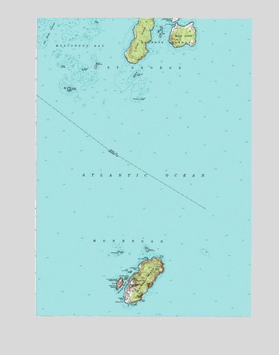
Monhegan, ME USGS Topographic Map
Click on map above to begin viewing in our Map Viewer.

This topographic map contains these locations and features:
Feature Name Type Latitude Longitude GNIS ID View Map
Allen IslandIslandN43.8668°W69.3142°561189View Map
Allen ShoalBarN43.7768°W69.2764°581672View Map
Black HeadSummitN43.7697°W69.3027°562436View Map
Burnt HeadSummitN43.7593°W69.3137°563230View Map
Burnt IslandIslandN43.8673°W69.2895°563239View Map
Calf CoveBayN43.7701°W69.3000°1909740View Map
Christmas CoveBayN43.7548°W69.3184°563973View Map
Deadman CoveBayN43.7695°W69.3159°564898View Map
Dry LedgesBarN43.8681°W69.3028°565315View Map
Duck RocksIslandN43.7768°W69.3245°565366View Map
Eastern Duck RockIslandN43.7779°W69.3098°565716View Map
Georges IslandsIslandN43.8668°W69.3089°581426View Map
Green PointCapeN43.7745°W69.3037°567254View Map
Gull Rock LedgeBarN43.7506°W69.3028°581757View Map
Harpoon LedgeBarN43.8531°W69.3481°567661View Map
Inner Duck RockIslandN43.7687°W69.3198°568642View Map
Lighthouse HillSummitN43.7651°W69.3156°1909834View Map
Little Burnt IslandIslandN43.8742°W69.2945°569716View Map
Little Egg RockIslandN43.8548°W69.3403°569765View Map
Little Egg Rock ShoalsBarN43.8501°W69.3481°581803View Map
Little WhiteheadSummitN43.7662°W69.3073°1909846View Map
Lobster CoveBayN43.7573°W69.3237°570136View Map
Lobster PointCapeN43.7562°W69.3225°570142View Map
Manana IslandIslandN43.7637°W69.3256°570693View Map
Manana Island Fog StationLocaleN43.7634°W69.3262°1909857View Map
Midway RocksBarN43.8745°W69.3698°581828View Map
MonheganPopulated PlaceN43.7623°W69.3203°571498View Map
Monhegan Fire Department Station 1BuildingN43.7621°W69.3203°2552937View Map
Monhegan HarborBayN43.7623°W69.3239°571499View Map
Monhegan IslandIslandN43.7665°W69.3114°571500View Map
Monhegan Island LightLocaleN43.7651°W69.2987°1909862View Map
Monhegan Island SchoolSchoolN43.7660°W69.3185°1909863View Map
Monhegan Memorial LibraryBuildingN43.7655°W69.3187°1909865View Map
Monhegan MuseumBuildingN43.7651°W69.3153°1909866View Map
Norton LedgeCapeN43.7568°W69.3137°572495View Map
Old Man LedgeBarN43.8412°W69.3150°572711View Map
Old Woman LedgeBarN43.8509°W69.3175°572738View Map
Pebbly BeachBeachN43.7737°W69.3087°1909898View Map
Plantation of MonheganCivilN43.7624°W69.3220°582600View Map
Pulpit RockPillarN43.7718°W69.3020°1909919View Map
Seal LedgesBarN43.7740°W69.3106°575116View Map
Seal LedgesBarN43.8734°W69.3409°575117View Map
Shark IslandIslandN43.8451°W69.3559°575310View Map
Smutty Nose IslandIslandN43.7656°W69.3223°575653View Map
Squeaker CoveBayN43.7668°W69.3042°1909961View Map
Sunken Duck RockBarN43.7787°W69.3259°581927View Map
Wash LedgeBarN43.8545°W69.3603°577854View Map
White HeadSummitN43.7629°W69.3089°578352View Map

Note: Coordinates in the location and feature list above are referenced to NAD83 datum.


Copyright (C) 2008-2025 Ryan Niemi / Sunset Dynamics ... All Rights Reserved