TopoQuest Logo
Do you find TopoQuest useful?
Help keep TopoQuest running and adding new maps/features by donating!
Bitcoin:  19c7KJd3qBynnjoSw5npx9KScwjBe4ifkT
Litecoin:  LXs6TkuXGGXo1vDsWCkWVdjQX94eUKd6ui
Home View Maps Find Maps Find Places Resources & Links


Louds Island, Maine Topographic Map

USGS Map Title: Louds Island, ME
USGS Map MRC: 43069H4
DRG (GeoTIFF) Download: o43069h4.tif


Neighboring USGS Topographic Map Quads:


  Damariscotta, ME  
44069A5
 

  Waldoboro West, ME  
44069A4
 

  Waldoboro East, ME  
44069A3
 

  Bristol, ME  
43069H5
 

  Louds Island, ME  
43069H4
 

  Friendship, ME  
43069H3
 

  Pemaquid Point, ME  
43069G5
 

  New Harbor, ME  
43069G4
 

  Monhegan, ME  
43069G3


Map MRC Location:

N44°
W70°
N44°
W69°
H8 H7 H6 H5 H4 H3 H2 H1
G8 G7 G6 G5 G4 G3 G2 G1
F8 F7 F6 F5 F4 F3 F2 F1
E8 E7 E6 E5 E4 E3 E2 E1
D8 D7 D6 D5 D4 D3 D2 D1
C8 C7 C6 C5 C4 C3 C2 C1
B8 B7 B6 B5 B4 B3 B2 B1
A8 A7 A6 A5 A4 A3 A2 A1
N43°
W70°
N43°
W69°

Louds Island, ME USGS 1:24K Topographic Map Preview:
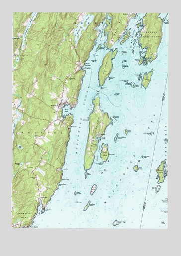
Louds Island, ME USGS Topographic Map
Click on map above to begin viewing in our Map Viewer.

This topographic map contains these locations and features:
Feature Name Type Latitude Longitude GNIS ID View Map
Bar IslandIslandN43.9067°W69.4409°561573View Map
Bar Island LedgeBarN43.9079°W69.4467°581677View Map
Boyd PondLakeN43.9324°W69.4995°562822View Map
Bremen Long IslandIslandN43.9901°W69.3875°562932View Map
Bristol Fire Station Round PondBuildingN43.9462°W69.4620°2553081View Map
Browns CoveBayN43.9090°W69.4598°563072View Map
Browns Head CoveBayN43.9006°W69.4623°563075View Map
Browns Head LedgeBarN43.8979°W69.4548°581695View Map
Bull PointCapeN43.9379°W69.4389°563162View Map
ChamberlainPopulated PlaceN43.8920°W69.4773°563799View Map
Chamberlain Post OfficePost OfficeN43.8915°W69.4773°1909748View Map
Clam IslandIslandN43.9929°W69.3987°564010View Map
Coombs LedgeBarN43.9531°W69.4170°564333View Map
Cow IslandIslandN43.9612°W69.3923°564411View Map
Cow Island Dry LedgesBarN43.9592°W69.4045°564415View Map
Cow Island LedgesBarN43.9637°W69.3975°564417View Map
Cow Island Sunken LedgesBarN43.9473°W69.4000°581713View Map
Crane IslandIslandN43.8981°W69.3831°564489View Map
Crotch IslandsIslandN43.9692°W69.4112°564583View Map
Crow IslandIslandN43.9773°W69.4114°564601View Map
Devils BackBarN43.8965°W69.4031°581720View Map
Devils ElbowBarN43.8945°W69.4087°581721View Map
Devils LimbBarN43.8967°W69.4150°581722View Map
Duryea Morton Audubon SanctuaryParkN43.9126°W69.3787°1909453View Map
Flying PassageChannelN43.9984°W69.3781°566330View Map
Franklin Island LightLocaleN43.8923°W69.3759°1909463View Map
Garden Island South LedgeBarN43.9270°W69.3906°581745View Map
Greenland CoveBayN43.9906°W69.4267°567275View Map
Haddock IslandIslandN43.8879°W69.4392°567412View Map
Haddock Island Kelp LedgeBarN43.8792°W69.4384°581760View Map
Haddock Island LedgeBarN43.8898°W69.4320°581761View Map
Halftide LedgeBarN43.9720°W69.4331°567470View Map
Harbor IslandIslandN43.9081°W69.3809°567587View Map
Harbor Island RockBarN43.9056°W69.3900°581769View Map
Hastings PondLakeN43.9120°W69.4923°567741View Map
Hockomock ChannelChannelN43.9915°W69.4023°568130View Map
Hockomock Nature TrailTrailN43.9815°W69.4253°1909818View Map
Hockomock PointCapeN43.9795°W69.4231°568132View Map
Hog IslandIslandN43.9673°W69.4256°568155View Map
Hog Island BarBarN43.9565°W69.4281°568169View Map
Hog Island LedgeBarN43.9623°W69.4214°568170View Map
Hough LedgeBarN43.8784°W69.3770°568343View Map
Indian IslandIslandN43.9395°W69.4178°568576View Map
Inner LedgeBarN43.9501°W69.4237°581785View Map
Jims IslandIslandN43.9579°W69.4023°568850View Map
Jims Island LedgeBarN43.9601°W69.4075°568851View Map
Jones Garden IslandIslandN43.9301°W69.3881°568961View Map
Keene NarrowsChannelN43.9862°W69.4109°581444View Map
Keene NeckRidgeN43.9970°W69.4112°581445View Map
Killick Stone IslandIslandN43.9279°W69.4164°569164View Map
Little Franklin LedgeBarN43.8854°W69.3750°569790View Map
Little PondLakeN43.9725°W69.4958°569970View Map
Long CoveBayN43.8848°W69.4773°570186View Map
Long Cove PointCapeN43.8865°W69.4739°570201View Map
Long Island LedgesBarN43.9837°W69.4017°570222View Map
Louds IslandIslandN43.9298°W69.4345°570427View Map
LoudvillePopulated PlaceN43.9287°W69.4309°570428View Map
Loudville CemeteryCemeteryN43.9226°W69.4328°570429View Map
Lower NarrowsChannelN43.9745°W69.4273°1909850View Map
Lower NarrowsChannelN43.9792°W69.4203°578895View Map
Maple Grove CemeteryCemeteryN43.9615°W69.4554°570722View Map
Marsh HarborBayN43.9187°W69.4312°570809View Map
Marsh IslandIslandN43.9181°W69.4259°570812View Map
Middle LedgesBarN43.9723°W69.4112°571253View Map
Moxie CoveBayN43.9340°W69.4539°571834View Map
MuscongusPopulated PlaceN43.9695°W69.4434°572005View Map
Muscongus BayBayN43.9215°W69.4000°572006View Map
Muscongus HarborBayN43.9676°W69.4431°572008View Map
Muscongus SoundBayN43.9423°W69.4448°572009View Map
National Audubon Society Nature CampLocaleN43.9701°W69.4245°1909874View Map
New HarborPopulated PlaceN43.8759°W69.4900°572116View Map
New Harbor PondReservoirN43.8789°W69.4954°1774383View Map
New Harbor Pond DamDamN43.8766°W69.4970°1774382View Map
New Harbor Post OfficePost OfficeN43.8785°W69.4994°1909875View Map
Oar IslandIslandN43.9851°W69.4092°572656View Map
Ocean Hill CemeteryCemeteryN43.9045°W69.4807°572661View Map
Palmer IslandIslandN43.9720°W69.3967°572945View Map
Pemaquid NeckCapeN43.8823°W69.4889°573144View Map
Poland LedgesBenchN43.9265°W69.4495°578907View Map
Poland North LedgeBarN43.9295°W69.4503°581864View Map
Poland South LedgeBarN43.9245°W69.4489°581865View Map
Polins East LedgeBarN43.9070°W69.4195°581866View Map
Polins LedgesBarN43.9084°W69.4262°581481View Map
Rachael Carson Salt Pond PreserveParkN43.8808°W69.4825°1909920View Map
Ram IslandIslandN43.9801°W69.4298°573993View Map
Ram LedgesBarN43.9751°W69.4337°574013View Map
Ross IslandIslandN43.8981°W69.4342°581486View Map
Ross PondLakeN43.9219°W69.4935°574467View Map
Round PondBayN43.9431°W69.4573°574487View Map
Round PondPopulated PlaceN43.9479°W69.4612°574526View Map
Round Pond Post OfficePost OfficeN43.9412°W69.4640°1909923View Map
Round RockBarN43.9215°W69.4109°581883View Map
Ruby AirportAirportN43.8947°W69.4954°2443610View Map
Salt Pond LedgeBarN43.8770°W69.4789°581887View Map
The White ChurchChurchN43.9467°W69.4623°1909964View Map
Thief IslandIslandN43.9312°W69.4087°576947View Map
Thrumcap IslandIslandN43.9126°W69.4298°577070View Map
Todd Wildlife SanctuaryParkN43.9701°W69.4245°1909967View Map
Town of BremenCivilN43.9973°W69.4214°582365View Map
Town of BristolCivilN43.8834°W69.4754°582369View Map
Unorganized Territory of Louds IslandCivilN43.9131°W69.4180°1954727View Map
Webber Dry LedgeBarN43.8954°W69.4487°577934View Map
Webber North LedgeBarN43.8990°W69.4489°581955View Map
Webber PondLakeN43.9921°W69.4435°580011View Map
Webber Sunken LedgeBarN43.8901°W69.4475°577940View Map
Western Egg RockIslandN43.8784°W69.4164°578250View Map
Wreck IslandIslandN43.9101°W69.4003°580705View Map
Wreck IslandIslandN43.9104°W69.4003°578713View Map
Wreck Island LedgesBarN43.9170°W69.3948°578715View Map

Note: Coordinates in the location and feature list above are referenced to NAD83 datum.


Copyright (C) 2008-2025 Ryan Niemi / Sunset Dynamics ... All Rights Reserved