TopoQuest Logo
Do you find TopoQuest useful?
Help keep TopoQuest running and adding new maps/features by donating!
Bitcoin:  19c7KJd3qBynnjoSw5npx9KScwjBe4ifkT
Litecoin:  LXs6TkuXGGXo1vDsWCkWVdjQX94eUKd6ui
Home View Maps Find Maps Find Places Resources & Links


Montgomery, Louisiana Topographic Map

USGS Map Title: Montgomery, LA
USGS Map MRC: 31092F8
DRG (GeoTIFF) Download: o31092f8.tif


Neighboring USGS Topographic Map Quads:


  Natchitoches North, LA  
31093G1
 

  Saint Maurice, LA  
31092G8
 

  Coochie Brake, LA  
31092G7
 

  Natchitoches South, LA  
31093F1
 

  Montgomery, LA  
31092F8
 

  Verda, LA  
31092F7
 

  Flora, LA  
31093E1
 

  Cloutierville, LA  
31092E8
 

  Aloha, LA  
31092E7


Map MRC Location:

N32°
W93°
N32°
W92°
H8 H7 H6 H5 H4 H3 H2 H1
G8 G7 G6 G5 G4 G3 G2 G1
F8 F7 F6 F5 F4 F3 F2 F1
E8 E7 E6 E5 E4 E3 E2 E1
D8 D7 D6 D5 D4 D3 D2 D1
C8 C7 C6 C5 C4 C3 C2 C1
B8 B7 B6 B5 B4 B3 B2 B1
A8 A7 A6 A5 A4 A3 A2 A1
N31°
W93°
N31°
W92°

Montgomery, LA USGS 1:24K Topographic Map Preview:
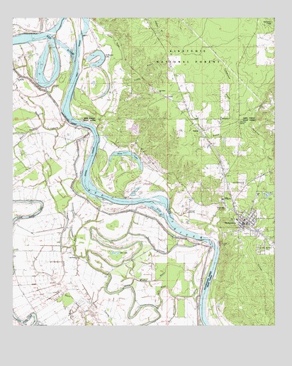
Montgomery, LA USGS Topographic Map
Click on map above to begin viewing in our Map Viewer.

This topographic map contains these locations and features:
Feature Name Type Latitude Longitude GNIS ID View Map
Bayou AthaoLakeN31.6571°W92.9768°553409View Map
Bayou CadocheLakeN31.7112°W92.9871°547009View Map
Bayou CognacGutN31.6646°W92.9685°547013View Map
Bayou CypressLakeN31.6283°W92.9539°553445View Map
Bayou des GlaizesLakeN31.6575°W92.9174°547004View Map
Bayou MilieuGutN31.6393°W92.9302°553494View Map
Bayou RoseauxGutN31.7035°W92.9938°547025View Map
Bayou SeepGutN31.6327°W92.9679°547028View Map
Ben LakeLakeN31.6588°W92.9538°553597View Map
BoleyPopulated PlaceN31.6857°W92.8988°545749View Map
Borden School (historical)SchoolN31.6527°W92.9679°548949View Map
Campground BranchStreamN31.7043°W92.8868°547179View Map
Cockfield (historical)Populated PlaceN31.6327°W92.9127°1630913View Map
Cockfield School (historical)SchoolN31.7038°W92.9860°548968View Map
Cognac (historical)Populated PlaceN31.6457°W92.9552°548970View Map
Creola CemeteryCemeteryN31.6585°W92.9013°547262View Map
CrewsPopulated PlaceN31.7179°W92.9279°554126View Map
Dunn LakeLakeN31.6951°W92.9460°554301View Map
Ebenezer Camp (historical)LocaleN31.7085°W92.8924°545762View Map
Ebenezer SpringSpringN31.7068°W92.8915°547336View Map
Hicks School (historical)SchoolN31.6538°W92.9265°549005View Map
Holy ChurchChurchN31.6791°W92.8838°548228View Map
Holy ChurchChurchN31.6788°W92.8838°541632View Map
KadeshPopulated PlaceN31.7043°W92.9113°547535View Map
Kadesh BranchStreamN31.7074°W92.8935°547536View Map
Mobly BayouLakeN31.6442°W92.9143°555344View Map
MontgomeryPopulated PlaceN31.6674°W92.8907°555353View Map
Montgomery Ferry (historical)CrossingN31.6604°W92.9040°545784View Map
Montgomery Gaines Junior High School (historical)SchoolN31.6765°W92.9000°554499View Map
Montgomery High SchoolSchoolN31.6678°W92.8929°545785View Map
Montgomery Police DepartmentBuildingN31.6665°W92.8909°2755349View Map
Montgomery Volunteer Fire DepartmentBuildingN31.6659°W92.8897°2672916View Map
Mount Vernon ChurchChurchN31.6560°W92.8807°547759View Map
New Beulah Church (historical)ChurchN31.6954°W92.9857°549051View Map
New Nazarene ChurchChurchN31.6360°W92.9682°555483View Map
New Nazarene Church (historical)ChurchN31.6699°W92.9313°549052View Map
New Salem ChurchChurchN31.7199°W92.9310°541652View Map
Old Montgomery (historical)Populated PlaceN31.6591°W92.9002°545791View Map
Petite EcoreCliffN31.7002°W92.9590°545806View Map
Pleasant Hill CemeteryCemeteryN31.6821°W92.8910°547855View Map
Pleasant Hill ChurchChurchN31.6727°W92.9002°547859View Map
Quinn BrakeSwampN31.7359°W92.9510°547875View Map
Robinson Landing StripAirportN31.6716°W92.9115°557067View Map
Saint Marthas ChurchChurchN31.7260°W92.9977°547933View Map
Saint Marys Church (historical)ChurchN31.6279°W92.9546°557088View Map
Saint Matthew ChurchChurchN31.6254°W92.9893°548916View Map
Saint Matthews SchoolSchoolN31.6254°W92.9893°555927View Map
Saint Maurice LakeLakeN31.7322°W92.9584°555928View Map
Town of MontgomeryCivilN31.6676°W92.8876°2406180View Map
Trestle BranchStreamN31.7104°W92.9577°548090View Map
Wheeler BayouLakeN31.6441°W92.9414°548139View Map
Williams Corner (historical)Populated PlaceN31.6688°W92.9290°548936View Map

Note: Coordinates in the location and feature list above are referenced to NAD83 datum.


Copyright (C) 2008-2024 Ryan Niemi / Sunset Dynamics ... All Rights Reserved