TopoQuest Logo
Do you find TopoQuest useful?
Help keep TopoQuest running and adding new maps/features by donating!
Bitcoin:  19c7KJd3qBynnjoSw5npx9KScwjBe4ifkT
Litecoin:  LXs6TkuXGGXo1vDsWCkWVdjQX94eUKd6ui
Home View Maps Find Maps Find Places Resources & Links


Montpelier, Iowa Topographic Map

USGS Map Title: Montpelier, IA
USGS Map MRC: 41090D7
DRG (GeoTIFF) Download: o41090d7.tif


Neighboring USGS Topographic Map Quads:


  Durant, IA  
41090E8
 

  Walcott, IA  
41090E7
 

  Davenport West, IA  
41090E6
 

  Illinois City, IL  
41090D8
 

  Montpelier, IA  
41090D7
 

  Andalusia, IL  
41090D6
 

  Eliza, IL  
41090C8
 

  Buffalo Prairie, IL  
41090C7
 

  Reynolds, IL  
41090C6


Map MRC Location:

N42°
W91°
N42°
W90°
H8 H7 H6 H5 H4 H3 H2 H1
G8 G7 G6 G5 G4 G3 G2 G1
F8 F7 F6 F5 F4 F3 F2 F1
E8 E7 E6 E5 E4 E3 E2 E1
D8 D7 D6 D5 D4 D3 D2 D1
C8 C7 C6 C5 C4 C3 C2 C1
B8 B7 B6 B5 B4 B3 B2 B1
A8 A7 A6 A5 A4 A3 A2 A1
N41°
W91°
N41°
W90°

Montpelier, IA USGS 1:24K Topographic Map Preview:
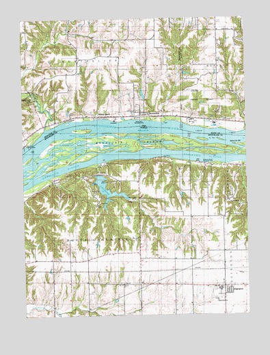
Montpelier, IA USGS Topographic Map
Click on map above to begin viewing in our Map Viewer.

This topographic map contains these locations and features:
Feature Name Type Latitude Longitude GNIS ID View Map
Andalusia Fire Protection District Station 2BuildingN41.3867°W90.7605°2640758View Map
Andalusia IslandIslandN41.4489°W90.8057°403498View Map
Andalusia Slough Recreation AreaParkN41.4392°W90.7754°425780View Map
Arab ChuteGutN41.4426°W90.8430°2747108View Map
Arab IslandIslandN41.4415°W90.8402°2747107View Map
Big BranchStreamN41.4398°W90.8321°404382View Map
Buffalo Prairie Town HallLocaleN41.3881°W90.8393°405165View Map
Camp Abe LincolnLocaleN41.4581°W90.7635°455101View Map
Clarks Ferry Recreation AreaParkN41.4578°W90.8096°465008View Map
Clarks Ferry Recreation AreaParkN41.4584°W90.8099°2000593View Map
Coal CreekStreamN41.4389°W90.7510°406294View Map
Dodge CemeteryCemeteryN41.4750°W90.8724°2000609View Map
EdgingtonPopulated PlaceN41.3870°W90.7638°426951View Map
Edgington High SchoolSchoolN41.3859°W90.7657°1748066View Map
Edgington Presbyterian ChurchChurchN41.3881°W90.7646°2042564View Map
Glendale School (historical)SchoolN41.4611°W90.8065°465083View Map
Green Bush School (historical)SchoolN41.4373°W90.7529°424047View Map
Heck HollowValleyN41.4313°W90.8579°1748068View Map
House of Prayer ChurchChurchN41.4598°W90.8068°465010View Map
Independent ChurchChurchN41.4603°W90.8110°465011View Map
Island Number 322IslandN41.4464°W90.7510°425047View Map
Lake GeorgeLakeN41.4235°W90.8261°408954View Map
Lone Cedar Picnic AreaLocaleN41.4286°W90.8204°425783View Map
Loud Thunder CampLocaleN41.4278°W90.8104°426952View Map
Loud Thunder Forest PreserveParkN41.4286°W90.8324°412675View Map
Midway BeachPopulated PlaceN41.4592°W90.8285°459069View Map
MontpelierLocaleN41.4592°W90.8071°2000592View Map
MontpelierPopulated PlaceN41.4592°W90.8071°459197View Map
Montpelier CemeteryCemeteryN41.4636°W90.8093°459198View Map
Montpelier Post Office (historical)Post OfficeN41.4592°W90.8071°2000591View Map
Montpelier Township Volunteer Fire DepartmentBuildingN41.4592°W90.8065°2577202View Map
Mud SloughLakeN41.4451°W90.7809°2747106View Map
Nye CemeteryCemeteryN41.4639°W90.8674°2000608View Map
Oak Hill School (historical)SchoolN41.4689°W90.7640°465131View Map
Oak Ridge School (historical)SchoolN41.4236°W90.7965°424081View Map
Old Pine Creek MillLocaleN41.4675°W90.8676°459833View Map
Open Door Baptist ChurchChurchN41.4592°W90.8071°2000590View Map
Patterson LakeLakeN41.4455°W90.8453°2747109View Map
Patterson School (historical)SchoolN41.4950°W90.8721°465137View Map
Pine CreekStreamN41.4536°W90.8629°460165View Map
Pine Creek Gristmill (historical)BuildingN41.4667°W90.8738°2000619View Map
Pine Mill BridgeBridgeN41.4675°W90.8696°2000621View Map
Pine Mills (historical)Populated PlaceN41.4695°W90.8710°465188View Map
Pine Mills Post Office (historical)Post OfficeN41.4695°W90.8746°2000466View Map
Saint Patrick Church (historical)ChurchN41.3884°W90.7632°424094View Map
Saint Patricks Catholic ChurchChurchN41.4223°W90.7593°425781View Map
Shady Creek Recreation AreaParkN41.4478°W90.8732°465007View Map
Shady Creek Recreation AreaParkN41.4473°W90.8746°2000533View Map
Silva CampgroundLocaleN41.4289°W90.8232°425782View Map
Sunfish SloughLakeN41.4450°W90.7709°2747105View Map
Township of Buffalo PrairieCivilN41.3908°W90.8388°428733View Map
Township of MontpelierCivilN41.4823°W90.8418°468402View Map
Valley Friends LakeReservoirN41.4249°W90.7865°1692483View Map
Valley Friends Lake DamDamN41.4267°W90.7851°1692482View Map
Velie ChuteStreamN41.4514°W90.8535°420245View Map
Village Oaks Landing Strip (historical)AirportN41.4692°W90.7804°465006View Map
White Lily School (historical)SchoolN41.3989°W90.8588°1748078View Map
Zion Lutheran ChurchChurchN41.3886°W90.8196°421661View Map
Zion Lutheran Church CemeteryCemeteryN41.3884°W90.8196°1967997View Map

Note: Coordinates in the location and feature list above are referenced to NAD83 datum.


Copyright (C) 2008-2024 Ryan Niemi / Sunset Dynamics ... All Rights Reserved