TopoQuest Logo
Do you find TopoQuest useful?
Help keep TopoQuest running and adding new maps/features by donating!
Bitcoin:  19c7KJd3qBynnjoSw5npx9KScwjBe4ifkT
Litecoin:  LXs6TkuXGGXo1vDsWCkWVdjQX94eUKd6ui
Home View Maps Find Maps Find Places Resources & Links


Montrose West, Colorado Topographic Map

USGS Map Title: Montrose West, CO
USGS Map MRC: 38107D8
DRG (GeoTIFF) Download: o38107d8.tif


Neighboring USGS Topographic Map Quads:


  Hoovers Corner, CO  
38108E1
 

  Olathe, CO  
38107E8
 

  Red Rock Canyon, CO  
38107E7
 

  Dry Creek Basin, CO  
38108D1
 

  Montrose West, CO  
38107D8
 

  Montrose East, CO  
38107D7
 

  Pryor Creek, CO  
38108C1
 

  Government Springs, CO  
38107C8
 

  Colona, CO  
38107C7


Map MRC Location:

N39°
W108°
N39°
W107°
H8 H7 H6 H5 H4 H3 H2 H1
G8 G7 G6 G5 G4 G3 G2 G1
F8 F7 F6 F5 F4 F3 F2 F1
E8 E7 E6 E5 E4 E3 E2 E1
D8 D7 D6 D5 D4 D3 D2 D1
C8 C7 C6 C5 C4 C3 C2 C1
B8 B7 B6 B5 B4 B3 B2 B1
A8 A7 A6 A5 A4 A3 A2 A1
N38°
W108°
N38°
W107°

Montrose West, CO USGS 1:24K Topographic Map Preview:
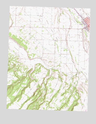
Montrose West, CO USGS Topographic Map
Click on map above to begin viewing in our Map Viewer.

This topographic map contains these locations and features:
Feature Name Type Latitude Longitude GNIS ID View Map
Alexander DamDamN38.4567°W107.9556°199194View Map
Alexander ReservoirReservoirN38.4567°W107.9556°199195View Map
Allerton DrawValleyN38.4181°W107.8954°188111View Map
B N B LateralCanalN38.4467°W107.9590°188106View Map
Baldridge ParkParkN38.4647°W107.8803°1795029View Map
Beaver HillSummitN38.4033°W107.9495°188110View Map
Buckley ParkParkN38.4853°W107.8759°1795110View Map
C J LateralCanalN38.4567°W107.9037°169349View Map
Centennial PlazaLocaleN38.4792°W107.8765°1795037View Map
Coltoc MineMineN38.4655°W107.9915°1763885View Map
DeVinney CanyonValleyN38.4041°W107.9422°188119View Map
Dolores CreekStreamN38.4314°W107.8906°188122View Map
Dolores PlacerMineN38.4775°W107.8778°1735586View Map
First Baptist ChurchChurchN38.4767°W107.8762°1795027View Map
Franklin MesaSummitN38.4897°W107.9940°203268View Map
Freshet DrawValleyN38.4117°W107.8925°188112View Map
Goodbye Dan MineMineN38.4775°W107.8778°1735587View Map
Grandview CemeteryCemeteryN38.4508°W107.8789°188117View Map
Happy Caņon Coal MineMineN38.4139°W107.8995°1745576View Map
Happy CanyonValleyN38.3914°W107.8882°188115View Map
Happy Canyon Aero Ranch Airport (historical)AirportN38.4164°W107.9012°204522View Map
Happy Canyon CreekStreamN38.4950°W107.9062°188116View Map
Hope Lutheran ChurchChurchN38.4828°W107.8765°1795114View Map
KUBC-AM (Montrose)TowerN38.4255°W107.8831°204043View Map
Lighthouse MissionChurchN38.4842°W107.8870°1795292View Map
Lindsay CanyonValleyN38.4263°W107.9609°188120View Map
Linscott CanyonValleyN38.4175°W107.9728°188104View Map
Maple Grove SchoolSchoolN38.4889°W107.9492°188107View Map
Marine Sand and Gravel PitMineN38.4775°W107.8778°1745577View Map
McNeil FieldsParkN38.4622°W107.8762°1795031View Map
MontrosePopulated PlaceN38.4783°W107.8762°203328View Map
Montrose and Delta CanalCanalN38.4400°W107.9103°203329View Map
Montrose ArroyoStreamN38.4933°W107.8820°188118View Map
Montrose City HallBuildingN38.4792°W107.8759°1795247View Map
Montrose County Court HouseBuildingN38.4783°W107.8767°1795034View Map
Montrose County Sheriff's OfficeBuildingN38.4871°W107.8910°2757251View Map
Montrose Lions Community BuildingBuildingN38.4875°W107.8778°1795112View Map
Montrose Lions ParkParkN38.4875°W107.8781°1795111View Map
Montrose Plaza Shopping CenterLocaleN38.4783°W107.8762°1763939View Map
Montrose Post OfficePost OfficeN38.4785°W107.8766°1795035View Map
Montrose Regional Airport Fire DepartmentBuildingN38.4995°W107.8974°2666965View Map
Montrose Regional LibraryBuildingN38.4792°W107.8762°1795036View Map
Morgan SchoolSchoolN38.4775°W107.8753°1795120View Map
North Side SchoolSchoolN38.4844°W107.8809°188109View Map
Northside Elementary SchoolSchoolN38.4841°W107.8805°1795113View Map
Oak GrovePopulated PlaceN38.4600°W107.9281°188108View Map
Ranger Ranch AirportAirportN38.4165°W107.9064°2770680View Map
Red Canyon MineMineN38.4775°W107.8778°1735588View Map
Schneider Ready Mix PitMineN38.4772°W107.8837°1745575View Map
Shavano Valley DitchCanalN38.4167°W107.9367°188105View Map
Sims MesaSummitN38.3822°W107.8790°188121View Map
Spring Creek MesaSummitN38.4308°W107.9345°203267View Map
Steel CanyonValleyN38.4119°W107.9624°188114View Map
Tappan CreekStreamN38.4297°W107.9198°188113View Map
Tomahawk MineMineN38.4775°W107.8778°1735585View Map
Ute ParkParkN38.4636°W107.8792°1795030View Map

Note: Coordinates in the location and feature list above are referenced to NAD83 datum.


Copyright (C) 2008-2024 Ryan Niemi / Sunset Dynamics ... All Rights Reserved