TopoQuest Logo
Do you find TopoQuest useful?
Help keep TopoQuest running and adding new maps/features by donating!
Bitcoin:  19c7KJd3qBynnjoSw5npx9KScwjBe4ifkT
Litecoin:  LXs6TkuXGGXo1vDsWCkWVdjQX94eUKd6ui
Home View Maps Find Maps Find Places Resources & Links


Olathe, Colorado Topographic Map

USGS Map Title: Olathe, CO
USGS Map MRC: 38107E8
DRG (GeoTIFF) Download: o38107e8.tif


Neighboring USGS Topographic Map Quads:


  Delta, CO  
38108F1
 

  Olathe NW, CO  
38107F8
 

  Black Ridge, CO  
38107F7
 

  Hoovers Corner, CO  
38108E1
 

  Olathe, CO  
38107E8
 

  Red Rock Canyon, CO  
38107E7
 

  Dry Creek Basin, CO  
38108D1
 

  Montrose West, CO  
38107D8
 

  Montrose East, CO  
38107D7


Map MRC Location:

N39°
W108°
N39°
W107°
H8 H7 H6 H5 H4 H3 H2 H1
G8 G7 G6 G5 G4 G3 G2 G1
F8 F7 F6 F5 F4 F3 F2 F1
E8 E7 E6 E5 E4 E3 E2 E1
D8 D7 D6 D5 D4 D3 D2 D1
C8 C7 C6 C5 C4 C3 C2 C1
B8 B7 B6 B5 B4 B3 B2 B1
A8 A7 A6 A5 A4 A3 A2 A1
N38°
W108°
N38°
W107°

Olathe, CO USGS 1:24K Topographic Map Preview:
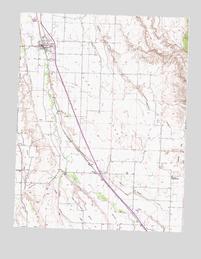
Olathe, CO USGS Topographic Map
Click on map above to begin viewing in our Map Viewer.

This topographic map contains these locations and features:
Feature Name Type Latitude Longitude GNIS ID View Map
Cedar CreekStreamN38.5105°W107.9181°186823View Map
Church of ChristChurchN38.6078°W107.9862°1795131View Map
Clifford FieldAirportN38.5717°W107.9558°204538View Map
Coal Creek SchoolSchoolN38.5330°W107.9956°186827View Map
Colorado State Patrol Troop 5C MontroseBuildingN38.5025°W107.9020°2757319View Map
Colorow Care CenterBuildingN38.6008°W107.9772°1795293View Map
Deadmans GulchValleyN38.5305°W107.9689°186828View Map
East MesaSummitN38.5553°W107.9198°203250View Map
First Baptist ChurchChurchN38.6064°W107.9873°1795294View Map
FrostPopulated PlaceN38.5672°W107.9701°186830View Map
Frost SchoolSchoolN38.5653°W107.9623°186829View Map
High MesaSummitN38.5333°W107.9901°203142View Map
Lions ParkParkN38.6050°W107.9842°1795128View Map
Menoken SchoolSchoolN38.5330°W107.9459°186825View Map
Mexican GulchValleyN38.5107°W107.9296°186821View Map
Montrose Regional AirportAirportN38.5081°W107.8966°203266View Map
Mountain Valley Baptist ChurchChurchN38.6094°W107.9803°1795134View Map
North Mesa Community HallLocaleN38.5319°W107.8845°186824View Map
OlathePopulated PlaceN38.6050°W107.9823°204746View Map
Olathe Assembly of GodChurchN38.6125°W107.9826°1795133View Map
Olathe CemeteryCemeteryN38.5985°W107.9761°1795122View Map
Olathe City HallBuildingN38.6050°W107.9840°1795125View Map
Olathe Community CenterBuildingN38.6067°W107.9876°1795129View Map
Olathe Elementary SchoolSchoolN38.6103°W107.9826°1795132View Map
Olathe High SchoolSchoolN38.6064°W107.9784°1795135View Map
Olathe Middle SchoolSchoolN38.6053°W107.9773°1795123View Map
Olathe Police DepartmentBuildingN38.6055°W107.9830°2757290View Map
Olathe Post OfficePost OfficeN38.6075°W107.9794°1795124View Map
Olathe United Methodist ChurchChurchN38.6044°W107.9845°1795127View Map
Olathe Volunteer Fire DepartmentBuildingN38.6049°W107.9829°1795126View Map
Our Lady of Fatima Catholic ChurchChurchN38.6064°W107.9859°1795130View Map
RoePopulated PlaceN38.5378°W107.9448°186826View Map
Selig CanalCanalN38.5547°W107.9028°203252View Map
Spring CreekStreamN38.5347°W107.9634°186822View Map
Town of OlatheCivilN38.6083°W107.9828°2413078View Map

Note: Coordinates in the location and feature list above are referenced to NAD83 datum.


Copyright (C) 2008-2025 Ryan Niemi / Sunset Dynamics ... All Rights Reserved