TopoQuest Logo
Do you find TopoQuest useful?
Help keep TopoQuest running and adding new maps/features by donating!
Bitcoin:  19c7KJd3qBynnjoSw5npx9KScwjBe4ifkT
Litecoin:  LXs6TkuXGGXo1vDsWCkWVdjQX94eUKd6ui
Home View Maps Find Maps Find Places Resources & Links


Moon Mountain, Washington Topographic Map

USGS Map Title: Moon Mountain, WA
USGS Map MRC: 48118C3
DRG (GeoTIFF) Download: o48118c3.tif


Neighboring USGS Topographic Map Quads:


  Sitdown Mountain, WA  
48118D4
 

  La Fleur Lake, WA  
48118D3
 

  Rice, WA  
48118D2
 

  Twin Lakes, WA  
48118C4
 

  Moon Mountain, WA  
48118C3
 

  Inchelium, WA  
48118C2
 

  Gold Mountain, WA  
48118B4
 

  Kewa, WA  
48118B3
 

  Cedonia, WA  
48118B2


Map MRC Location:

N49°
W119°
N49°
W118°
H8 H7 H6 H5 H4 H3 H2 H1
G8 G7 G6 G5 G4 G3 G2 G1
F8 F7 F6 F5 F4 F3 F2 F1
E8 E7 E6 E5 E4 E3 E2 E1
D8 D7 D6 D5 D4 D3 D2 D1
C8 C7 C6 C5 C4 C3 C2 C1
B8 B7 B6 B5 B4 B3 B2 B1
A8 A7 A6 A5 A4 A3 A2 A1
N48°
W119°
N48°
W118°

Moon Mountain, WA USGS 1:24K Topographic Map Preview:
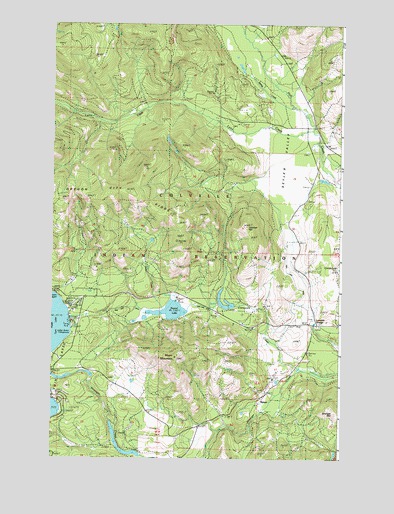
Moon Mountain, WA USGS Topographic Map
Click on map above to begin viewing in our Map Viewer.

This topographic map contains these locations and features:
Feature Name Type Latitude Longitude GNIS ID View Map
Abraham CreekStreamN48.3746°W118.2853°1515715View Map
Carson BeachBeachN48.2968°W118.3722°1528738View Map
Cedar CreekStreamN48.2957°W118.3233°1517537View Map
Cornstalk CreekStreamN48.2732°W118.2578°1518114View Map
Hall RanchLocaleN48.3282°W118.2644°1520469View Map
Hidden Beach CampgroundLocaleN48.2860°W118.3658°1528737View Map
Johhnys HillSummitN48.3166°W118.2908°1521400View Map
Lakeside GrangeLocaleN48.2891°W118.2594°1521866View Map
Lynx CreekStreamN48.3441°W118.2606°1522610View Map
MeteorPopulated PlaceN48.2663°W118.2850°1523029View Map
Moon MountainSummitN48.2791°W118.3214°1523346View Map
Moon Mountain LookoutLocaleN48.2793°W118.3217°1530357View Map
Round LakeSwampN48.2921°W118.3265°1525236View Map
Seyler ValleyFlatN48.3341°W118.2758°1525597View Map
Spring CreekStreamN48.3507°W118.2683°1526410View Map
Twin Lakes Census Designated PlaceCensusN48.2622°W118.3591°2585047View Map
Twin Lakes DitchStreamN48.2935°W118.3011°1528449View Map

Note: Coordinates in the location and feature list above are referenced to NAD83 datum.


Copyright (C) 2008-2025 Ryan Niemi / Sunset Dynamics ... All Rights Reserved