TopoQuest Logo
Do you find TopoQuest useful?
Help keep TopoQuest running and adding new maps/features by donating!
Bitcoin:  19c7KJd3qBynnjoSw5npx9KScwjBe4ifkT
Litecoin:  LXs6TkuXGGXo1vDsWCkWVdjQX94eUKd6ui
Home View Maps Find Maps Find Places Resources & Links


Inchelium, Washington Topographic Map

USGS Map Title: Inchelium, WA
USGS Map MRC: 48118C2
DRG (GeoTIFF) Download: o48118c2.tif


Neighboring USGS Topographic Map Quads:


  La Fleur Lake, WA  
48118D3
 

  Rice, WA  
48118D2
 

  Kentry Ridge, WA  
48118D1
 

  Moon Mountain, WA  
48118C3
 

  Inchelium, WA  
48118C2
 

  Wellington Peak, WA  
48118C1
 

  Kewa, WA  
48118B3
 

  Cedonia, WA  
48118B2
 

  Blackhorse Canyon, WA  
48118B1


Map MRC Location:

N49°
W119°
N49°
W118°
H8 H7 H6 H5 H4 H3 H2 H1
G8 G7 G6 G5 G4 G3 G2 G1
F8 F7 F6 F5 F4 F3 F2 F1
E8 E7 E6 E5 E4 E3 E2 E1
D8 D7 D6 D5 D4 D3 D2 D1
C8 C7 C6 C5 C4 C3 C2 C1
B8 B7 B6 B5 B4 B3 B2 B1
A8 A7 A6 A5 A4 A3 A2 A1
N48°
W119°
N48°
W118°

Inchelium, WA USGS 1:24K Topographic Map Preview:
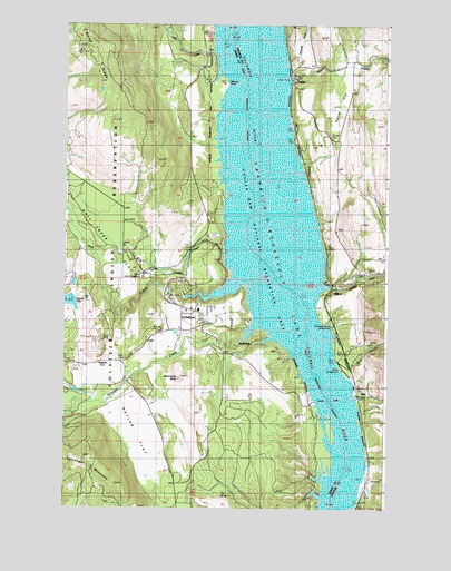
Inchelium, WA USGS Topographic Map
Click on map above to begin viewing in our Map Viewer.

This topographic map contains these locations and features:
Feature Name Type Latitude Longitude GNIS ID View Map
Bissell FlatsBarN48.2579°W118.1364°1528810View Map
Bissell IslandIslandN48.2707°W118.1469°1528811View Map
Buck CanyonValleyN48.2874°W118.1389°1517020View Map
Butler FlatFlatN48.2685°W118.2233°1517151View Map
Camille LakeLakeN48.3033°W118.2480°1517248View Map
Cloverleaf Beach CampgroundLocaleN48.2971°W118.1467°1528721View Map
Cobbs CreekStreamN48.3174°W118.1886°1517902View Map
Colville Indian SubagencyLocaleN48.3099°W118.2203°1517984View Map
DaisyPopulated PlaceN48.3613°W118.1600°1518454View Map
Deer CreekStreamN48.2785°W118.1364°1518614View Map
Edendale (historical)Populated PlaceN48.3154°W118.1500°1530611View Map
Evergreen Elementary SchoolSchoolN48.3095°W118.1391°1530743View Map
GiffordPopulated PlaceN48.3063°W118.1464°1519950View Map
Gifford CampgroundLocaleN48.2860°W118.1428°1528720View Map
Gifford Ferry LandingLocaleN48.2783°W118.1373°2608112View Map
Gifford Post OfficePost OfficeN48.3066°W118.1467°2769258View Map
Guinn MineMineN48.2929°W118.2353°1520405View Map
Hall CreekStreamN48.3046°W118.2036°1520465View Map
Hall Creek FlatFlatN48.3232°W118.2378°1520466View Map
ImpachPopulated PlaceN48.2882°W118.2367°1521147View Map
IncheliumPopulated PlaceN48.2968°W118.1967°1521149View Map
Inchelium Census Designated PlaceCensusN48.3379°W118.2372°2408416View Map
Inchelium Elementary SchoolSchoolN48.3014°W118.1982°2606512View Map
Inchelium Ferry LandingLocaleN48.2777°W118.1536°2608113View Map
Inchelium High SchoolSchoolN48.3014°W118.1982°2606555View Map
Inchelium Middle SchoolSchoolN48.3014°W118.1982°2606542View Map
Inchelium Post OfficePost OfficeN48.2994°W118.1970°2781709View Map
Inchelium School District Number 70SchoolN48.3013°W118.1983°1534213View Map
Jennings CreekStreamN48.3652°W118.1639°1521352View Map
Little Jim CreekStreamN48.3679°W118.1930°1522244View Map
Magee CreekStreamN48.3604°W118.1628°1522631View Map
Magee Creek AerodromeAirportN48.3637°W118.1414°2770669View Map
Monument ButteSummitN48.2829°W118.2058°1523334View Map
Saints FlatFlatN48.3560°W118.1428°1525378View Map
Stevens County Fire District 12 Station 121BuildingN48.3101°W118.1380°2619645View Map
Stranger CreekStreamN48.2929°W118.1822°1526615View Map
Stranger CreekStreamN48.3071°W118.1469°1526616View Map
Stranger MountainSummitN48.2629°W118.2400°1526619View Map
Ward SchoolSchoolN48.2793°W118.1339°1527804View Map

Note: Coordinates in the location and feature list above are referenced to NAD83 datum.


Copyright (C) 2008-2024 Ryan Niemi / Sunset Dynamics ... All Rights Reserved