TopoQuest Logo
Do you find TopoQuest useful?
Help keep TopoQuest running and adding new maps/features by donating!
Bitcoin:  19c7KJd3qBynnjoSw5npx9KScwjBe4ifkT
Litecoin:  LXs6TkuXGGXo1vDsWCkWVdjQX94eUKd6ui
Home View Maps Find Maps Find Places Resources & Links


Moore, South Carolina Topographic Map

USGS Map Title: Moore, SC
USGS Map MRC: 34081G8
DRG (GeoTIFF) Download: o34081g8.tif


Neighboring USGS Topographic Map Quads:


  Wellford, SC  
34082H1
 

  Spartanburg, SC  
34081H8
 

  Pacolet, SC  
34081H7
 

  Reidville, SC  
34082G1
 

  Moore, SC  
34081G8
 

  Glenn Springs, SC  
34081G7
 

  Woodruff, SC  
34082F1
 

  Enoree, SC  
34081F8
 

  Cross Anchor, SC  
34081F7


Map MRC Location:

N35°
W82°
N35°
W81°
H8 H7 H6 H5 H4 H3 H2 H1
G8 G7 G6 G5 G4 G3 G2 G1
F8 F7 F6 F5 F4 F3 F2 F1
E8 E7 E6 E5 E4 E3 E2 E1
D8 D7 D6 D5 D4 D3 D2 D1
C8 C7 C6 C5 C4 C3 C2 C1
B8 B7 B6 B5 B4 B3 B2 B1
A8 A7 A6 A5 A4 A3 A2 A1
N34°
W82°
N34°
W81°

Moore, SC USGS 1:24K Topographic Map Preview:
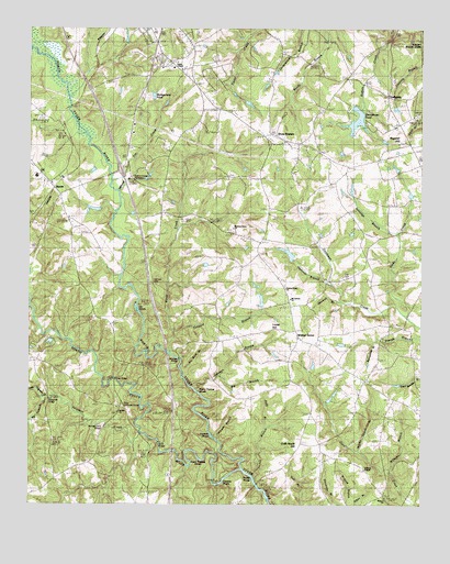
Moore, SC USGS Topographic Map
Click on map above to begin viewing in our Map Viewer.

This topographic map contains these locations and features:
Feature Name Type Latitude Longitude GNIS ID View Map
Alexander BridgeBridgeN34.7773°W81.9937°1220152View Map
Big BranchStreamN34.7837°W81.9390°1220680View Map
Big Ferguson CreekStreamN34.7779°W81.9943°1245687View Map
Cathcart CemeteryCemeteryN34.8085°W81.9609°1221406View Map
Chesnee ShoalsRapidsN34.7560°W81.9407°1221551View Map
Crab Apple HillSummitN34.7662°W81.9132°1221809View Map
Crooked Fence Farm AirportAirportN34.7711°W81.9893°2650816View Map
Ferguson CreekStreamN34.7682°W81.9637°1227791View Map
Foster Chapel Baptist ChurchChurchN34.8646°W81.9540°1248272View Map
Foster School (historical)SchoolN34.8657°W81.9570°1245728View Map
GatewoodPopulated PlaceN34.8579°W81.9665°1248285View Map
George Ford BridgeBridgeN34.7704°W81.9762°1222674View Map
GolightlyPopulated PlaceN34.8573°W81.8854°1231329View Map
Golightly ChurchChurchN34.8710°W81.8851°1222745View Map
Golightly School (historical)SchoolN34.8632°W81.8840°1248294View Map
Golightly United Methodist ChurchChurchN34.8626°W81.8854°1248295View Map
Harrison BranchStreamN34.8076°W81.9034°1223060View Map
Harrison Grove Baptist ChurchChurchN34.8223°W81.9351°1245920View Map
Harrison Grove School (historical)SchoolN34.8223°W81.9351°1248312View Map
Harrison ShoalsRapidsN34.7654°W81.9382°1223065View Map
Hebron United Methodist CemeteryCemeteryN34.7510°W81.8859°1248313View Map
Hebron United Methodist ChurchChurchN34.7512°W81.8862°1245946View Map
Holiness ChurchChurchN34.8362°W81.9368°1248328View Map
Interchange 28CrossingN34.8379°W81.9707°1228180View Map
Jennings BranchStreamN34.8215°W81.8832°1223543View Map
Johnson BranchStreamN34.7807°W81.9476°1223601View Map
Kelly BranchStreamN34.7704°W81.9243°1223707View Map
L E Gable Middle SchoolSchoolN34.8560°W81.9457°1248351View Map
Little Ferguson CreekStreamN34.7779°W81.9951°1246397View Map
Lucas HillSummitN34.7968°W81.9226°1231509View Map
Marches BridgeBridgeN34.7885°W81.9526°1224306View Map
Martha Shands BranchStreamN34.7640°W81.8948°1224336View Map
Middle Tyger RiverStreamN34.8693°W81.9984°1246634View Map
Millville (historical)Populated PlaceN34.7751°W81.9540°1782055View Map
Montgomery PondReservoirN34.8555°W81.9563°1224624View Map
MoorePopulated PlaceN34.8335°W81.9920°1231558View Map
Moore ChurchChurchN34.8290°W81.9895°1248410View Map
Moore School (historical)SchoolN34.8293°W81.9895°1248412View Map
Moores BridgeBridgeN34.8368°W81.9737°1248413View Map
Mount Calvary Presbyterian ChurchChurchN34.8026°W81.9157°1249555View Map
Nancy Thomas ShoalsRapidsN34.7654°W81.9387°1224921View Map
Nesbit ShoalsRapidsN34.7558°W81.9277°1224951View Map
Nesbitt SchoolSchoolN34.7612°W81.8984°1224952View Map
Nesbitts Bridge (historical)BridgeN34.7540°W81.9257°1248437View Map
Newman BranchStreamN34.8035°W81.9004°1225038View Map
Nichol BranchStreamN34.7596°W81.9315°1225044View Map
North Tyger RiverStreamN34.7593°W81.9318°1249894View Map
Old Golightly Mill (historical)LocaleN34.8732°W81.8845°1248466View Map
Ott ShoalsRapidsN34.8012°W81.9659°1225254View Map
Pauline DivisionCivilN34.8042°W81.8827°1938380View Map
Pennywinkle BranchStreamN34.7924°W81.8893°1225366View Map
Pine Grove School (historical)SchoolN34.8465°W81.9254°1248496View Map
Price BridgeBridgeN34.7829°W81.9726°1225665View Map
Price Historical HouseBuildingN34.7760°W81.9698°1248516View Map
Prices Post Office (historical)Post OfficeN34.7760°W81.9701°1248517View Map
R P Anderson Area Vocational CenterSchoolN34.8362°W81.9976°1248520View Map
Riverside SchoolSchoolN34.7501°W81.9259°1225902View Map
Roebuck Fire Department Station 1BuildingN34.8684°W81.9570°2578875View Map
Roebuck Primary SchoolSchoolN34.8648°W81.9576°1248540View Map
Rogers BridgeBridgeN34.7554°W81.9270°1248541View Map
Scott BridgeBridgeN34.7665°W81.9582°1226453View Map
Sherberts LakeReservoirN34.8160°W81.9173°1238681View Map
Smith CreekStreamN34.7999°W81.8798°1250933View Map
Smiths TavernPopulated PlaceN34.8640°W81.9387°1248579View Map
South Carolina Noname 42009 D-3357 DamDamN34.8535°W81.8937°1238662View Map
South Carolina Noname 42021 D-3358 DamDamN34.8151°W81.9165°1238680View Map
South Tyger RiverStreamN34.7596°W81.9315°1250970View Map
Stillhouse BranchStreamN34.8329°W81.9726°1226891View Map
Stone StationPopulated PlaceN34.8462°W81.9254°1251051View Map
Stone Station Church (historical)ChurchN34.8465°W81.9254°1248618View Map
Susan Thomas ShoalsRapidsN34.7622°W81.9456°1226977View Map
Switzer ChurchChurchN34.7740°W81.9720°1251098View Map
Tanyard BranchStreamN34.7951°W81.9534°1227034View Map
Thomas BranchStreamN34.7682°W81.9415°1227094View Map
Tim CreekStreamN34.8362°W81.9737°1227141View Map
Tin Roof BranchStreamN34.7851°W81.9512°1227152View Map
Trail CemeteryCemeteryN34.8093°W81.8982°1227191View Map
Underwood SchoolSchoolN34.8437°W81.9118°1227281View Map
Walnut GrovePopulated PlaceN34.7943°W81.9140°1231889View Map
Walnut Grove CemeteryCemeteryN34.8076°W81.9184°1248660View Map
Walnut Grove PlantationLocaleN34.8360°W81.9651°1248661View Map
Walnut Grove School (historical)SchoolN34.7954°W81.9151°1248662View Map
Walnut Grove United Methodist ChurchChurchN34.8068°W81.9182°1251317View Map
Wards CreekStreamN34.7896°W81.9545°1227398View Map
Williams BranchStreamN34.7593°W81.8848°1227608View Map
Wofford ChapelChurchN34.7593°W81.8929°1251488View Map
Zimmerman PondReservoirN34.8514°W81.8950°1227743View Map

Note: Coordinates in the location and feature list above are referenced to NAD83 datum.


Copyright (C) 2008-2024 Ryan Niemi / Sunset Dynamics ... All Rights Reserved