TopoQuest Logo
Do you find TopoQuest useful?
Help keep TopoQuest running and adding new maps/features by donating!
Bitcoin:  19c7KJd3qBynnjoSw5npx9KScwjBe4ifkT
Litecoin:  LXs6TkuXGGXo1vDsWCkWVdjQX94eUKd6ui
Home View Maps Find Maps Find Places Resources & Links


Cross Anchor, South Carolina Topographic Map

USGS Map Title: Cross Anchor, SC
USGS Map MRC: 34081F7
DRG (GeoTIFF) Download: o34081f7.tif


Neighboring USGS Topographic Map Quads:


  Moore, SC  
34081G8
 

  Glenn Springs, SC  
34081G7
 

  Jonesville, SC  
34081G6
 

  Enoree, SC  
34081F8
 

  Cross Anchor, SC  
34081F7
 

  Union West, SC  
34081F6
 

  Ora, SC  
34081E8
 

  Philson Crossroads, SC  
34081E7
 

  Sedalia, SC  
34081E6


Map MRC Location:

N35°
W82°
N35°
W81°
H8 H7 H6 H5 H4 H3 H2 H1
G8 G7 G6 G5 G4 G3 G2 G1
F8 F7 F6 F5 F4 F3 F2 F1
E8 E7 E6 E5 E4 E3 E2 E1
D8 D7 D6 D5 D4 D3 D2 D1
C8 C7 C6 C5 C4 C3 C2 C1
B8 B7 B6 B5 B4 B3 B2 B1
A8 A7 A6 A5 A4 A3 A2 A1
N34°
W82°
N34°
W81°

Cross Anchor, SC USGS 1:24K Topographic Map Preview:
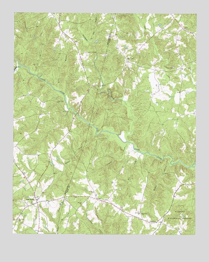
Cross Anchor, SC USGS Topographic Map
Click on map above to begin viewing in our Map Viewer.

This topographic map contains these locations and features:
Feature Name Type Latitude Longitude GNIS ID View Map
Beddington MountainSummitN34.7249°W81.8048°1251723View Map
Belmont CemeteryCemeteryN34.6428°W81.8270°1229397View Map
Belmont Church (historical)ChurchN34.6424°W81.8276°1232825View Map
Black Jack Valley (historical)Populated PlaceN34.6860°W81.8026°1232833View Map
Blackstock Road CemeteryCemeteryN34.6565°W81.8229°1232835View Map
Blackstocks FordCrossingN34.6815°W81.8040°1232836View Map
Bogansville Church (historical)ChurchN34.7479°W81.7648°1241320View Map
Burnt Factory BridgeBridgeN34.6932°W81.8318°1248147View Map
Cane CreekStreamN34.7135°W81.8576°1229516View Map
Church of GodChurchN34.6540°W81.7526°1241321View Map
ColerainPopulated PlaceN34.7237°W81.7979°1232864View Map
Colerain School (historical)SchoolN34.7218°W81.7932°1232865View Map
Cowdens CreekStreamN34.6712°W81.7879°1229600View Map
Cross AnchorPopulated PlaceN34.6429°W81.8579°1231206View Map
Cross Anchor Census Designated PlaceCensusN34.6440°W81.8585°2629823View Map
Cross Anchor Fire DepartmentBuildingN34.6417°W81.8574°2578454View Map
Cross Anchor School (historical)SchoolN34.6376°W81.8543°1248231View Map
Cross KeysPopulated PlaceN34.6321°W81.7768°1247434View Map
Cross Keys Fire DepartmentBuildingN34.6366°W81.7699°2578630View Map
Cross Keys School (historical)SchoolN34.6324°W81.7790°1232868View Map
D Correctional Pond Dam D-3391DamN34.7051°W81.8398°1240417View Map
Dry BranchStreamN34.7335°W81.8220°1229654View Map
DutchmanPopulated PlaceN34.7415°W81.8432°1248030View Map
Dutchman CreekStreamN34.6776°W81.7965°1247582View Map
Dutchman School (historical)SchoolN34.7390°W81.8415°1248031View Map
G H Southerland Pond Dam D-3392DamN34.6418°W81.8415°1240418View Map
Grace Chapel (historical)ChurchN34.7001°W81.8454°1248297View Map
Grace Chapel CemeteryCemeteryN34.6998°W81.8448°1229742View Map
Green Pond School (historical)SchoolN34.7496°W81.8087°1248302View Map
Hackers CreekStreamN34.6821°W81.8184°1245874View Map
Jimmies CreekStreamN34.7199°W81.8704°1246173View Map
Lawson CemeteryCemeteryN34.6907°W81.7687°1232950View Map
Macedonia ChurchChurchN34.6368°W81.7868°1229965View Map
Meadow WoodsAreaN34.6949°W81.7776°1232973View Map
Mill CreekStreamN34.6707°W81.7868°1230010View Map
Motley BranchStreamN34.7060°W81.8437°1230045View Map
Mount Calvary Baptist ChurchChurchN34.6371°W81.7879°1249554View Map
Mount Calvary School (historical)SchoolN34.6382°W81.7876°1232980View Map
Mount Lebanon Baptist ChurchChurchN34.7246°W81.7973°1249597View Map
Mount Lebanon Baptist Church CemeteryCemeteryN34.7248°W81.7979°1247924View Map
Mount Zion ChurchChurchN34.6265°W81.8576°1249729View Map
New Hope Baptist Church (historical)ChurchN34.6337°W81.8712°1248439View Map
New Hope Baptist Church GraveyardCemeteryN34.6331°W81.8711°1230095View Map
Putman Baptist ChurchChurchN34.7418°W81.7582°1250272View Map
Putnam CemeteryCemeteryN34.7410°W81.7570°1233009View Map
Putnam School (historical)SchoolN34.7418°W81.7584°1233010View Map
Spring Hill CemeteryCemeteryN34.6490°W81.8193°1230357View Map
Spring Hill Christian Methodist Episcopal ChurchChurchN34.6487°W81.8193°1233046View Map
Trail BranchStreamN34.7485°W81.8682°1230421View Map
Tyger River Correctional InstitutionBuildingN34.7129°W81.8272°2735640View Map
Vernon BridgeBridgeN34.7093°W81.8137°1247996View Map
West Springs DivisionCivilN34.7247°W81.7500°1938464View Map
Wildcat (historical)Populated PlaceN34.6365°W81.8318°1233088View Map
Wofford BranchStreamN34.6651°W81.7670°1230517View Map
Wyatts ChapelChurchN34.7196°W81.7659°1251519View Map
Wyatts School (historical)SchoolN34.7185°W81.7790°1251727View Map

Note: Coordinates in the location and feature list above are referenced to NAD83 datum.


Copyright (C) 2008-2024 Ryan Niemi / Sunset Dynamics ... All Rights Reserved