TopoQuest Logo
Do you find TopoQuest useful?
Help keep TopoQuest running and adding new maps/features by donating!
Bitcoin:  19c7KJd3qBynnjoSw5npx9KScwjBe4ifkT
Litecoin:  LXs6TkuXGGXo1vDsWCkWVdjQX94eUKd6ui
Home View Maps Find Maps Find Places Resources & Links


Mooringsport, Louisiana Topographic Map

USGS Map Title: Mooringsport, LA
USGS Map MRC: 32093F8
DRG (GeoTIFF) Download: o32093f8.tif


Neighboring USGS Topographic Map Quads:


  Trees, LA  
32094G1
 

  Vivian South, LA  
32093G8
 

  Gilliam, LA  
32093G7
 

  Potters Point, TX  
32094F1
 

  Mooringsport, LA  
32093F8
 

  Dixie, LA  
32093F7
 

  Latex, TX  
32094E1
 

  Blanchard, LA  
32093E8
 

  North Highlands, LA  
32093E7


Map MRC Location:

N33°
W94°
N33°
W93°
H8 H7 H6 H5 H4 H3 H2 H1
G8 G7 G6 G5 G4 G3 G2 G1
F8 F7 F6 F5 F4 F3 F2 F1
E8 E7 E6 E5 E4 E3 E2 E1
D8 D7 D6 D5 D4 D3 D2 D1
C8 C7 C6 C5 C4 C3 C2 C1
B8 B7 B6 B5 B4 B3 B2 B1
A8 A7 A6 A5 A4 A3 A2 A1
N32°
W94°
N32°
W93°

Mooringsport, LA USGS 1:24K Topographic Map Preview:
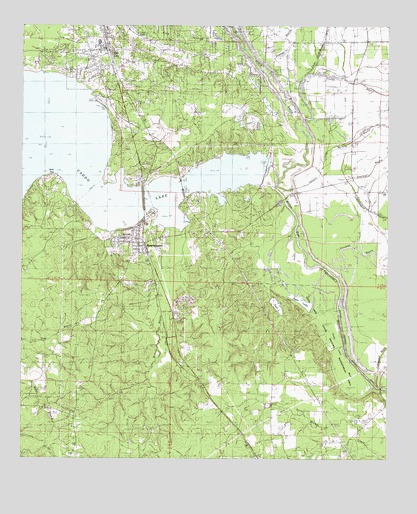
Mooringsport, LA USGS Topographic Map
Click on map above to begin viewing in our Map Viewer.

This topographic map contains these locations and features:
Feature Name Type Latitude Longitude GNIS ID View Map
ArlatexPopulated PlaceN32.6779°W93.9535°552213View Map
Baptist TempleChurchN32.6693°W93.9718°540782View Map
Black BayouStreamN32.7047°W93.9131°533169View Map
BrianPopulated PlaceN32.6385°W93.9307°552225View Map
Bridge 184BridgeN32.6457°W93.8777°533389View Map
Caddo DamDamN32.7102°W93.9166°556885View Map
Caddo LakeReservoirN32.7085°W93.9174°1372868View Map
Caddo Parish Fire District 7BuildingN32.7457°W93.9778°2672796View Map
Caddo Parish Sheriff's OfficeBuildingN32.7273°W93.9706°2755229View Map
Canfiels PointCapeN32.7129°W93.9085°552245View Map
Clear LakeLakeN32.7475°W93.9615°554019View Map
Cottonwood BayouStreamN32.6463°W93.8788°554098View Map
Crooked BayouStreamN32.6788°W93.8918°534258View Map
Egan LakeLakeN32.6698°W93.9033°554348View Map
First Baptist ChurchChurchN32.7438°W93.9755°557902View Map
Fish LakeReservoirN32.6694°W93.9131°554413View Map
Fish Lake DamDamN32.6713°W93.9155°557019View Map
KDAQ-FM (Shreveport)TowerN32.6782°W93.9266°1632482View Map
KITT-FM (Shreveport)TowerN32.6776°W93.9282°1632483View Map
KLTS-TV (Shreveport)TowerN32.6782°W93.9266°1632503View Map
KRMD-FM (Shreveport)TowerN32.6857°W93.9335°1632485View Map
KSLA-TV (Shreveport)TowerN32.6749°W93.9332°1632505View Map
KTBS-TV (Shreveport)TowerN32.6857°W93.9335°1632504View Map
KWKH-AM (Shreveport)TowerN32.7043°W93.8813°1632562View Map
KWKH-FM (Shreveport)TowerN32.6704°W93.9332°1632484View Map
Lake Zion ChurchChurchN32.7463°W93.8830°536306View Map
Longwood Lookout TowerTowerN32.6379°W93.9818°558798View Map
MooringsportPopulated PlaceN32.6876°W93.9610°555365View Map
Mooringsport Baptist ChurchChurchN32.6885°W93.9613°557903View Map
Mooringsport Elementary SchoolSchoolN32.6868°W93.9605°552361View Map
Mooringsport Post OfficePost OfficeN32.6921°W93.9593°1631887View Map
Mooringsport United Methodist ChurchChurchN32.6913°W93.9621°557904View Map
Myricks BayouStreamN32.7140°W93.8966°555452View Map
Oil CityPopulated PlaceN32.7440°W93.9716°543554View Map
Oil City Elementary Magnet SchoolSchoolN32.7483°W93.9708°552377View Map
Rocky PointCapeN32.7065°W93.9893°538677View Map
Saint Johns ChurchChurchN32.6693°W93.9321°538898View Map
Saint Paul Baptist ChurchChurchN32.6607°W93.9966°552495View Map
Saint Paul SchoolSchoolN32.6610°W93.9963°539032View Map
Shift-Tail Lake (historical)LakeN32.7157°W93.8957°552419View Map
Shiftail CanalCanalN32.7074°W93.9002°539332View Map
Soda Lake BedFlatN32.6599°W93.8949°558321View Map
Soda Lake State Wildlife Management AreaParkN32.6596°W93.8930°540783View Map
Sterling BayouGutN32.7071°W93.8868°539658View Map
Stormy PointCapeN32.7043°W93.9721°552446View Map
Stumpy BayouStreamN32.7318°W93.9107°539704View Map
Swift BayouStreamN32.7363°W93.9032°539770View Map
Town of MooringsportCivilN32.6832°W93.9607°2406190View Map
Town of Oil CityCivilN32.7453°W93.9758°2407038View Map
Walnut BayouStreamN32.6913°W93.9449°540215View Map
Willow PassChannelN32.6932°W93.9074°556442View Map

Note: Coordinates in the location and feature list above are referenced to NAD83 datum.


Copyright (C) 2008-2024 Ryan Niemi / Sunset Dynamics ... All Rights Reserved