TopoQuest Logo
Do you find TopoQuest useful?
Help keep TopoQuest running and adding new maps/features by donating!
Bitcoin:  19c7KJd3qBynnjoSw5npx9KScwjBe4ifkT
Litecoin:  LXs6TkuXGGXo1vDsWCkWVdjQX94eUKd6ui
Home View Maps Find Maps Find Places Resources & Links


Beech Bluff, Tennessee Topographic Map

USGS Map Title: Beech Bluff, TN
USGS Map MRC: 35088E6
DRG (GeoTIFF) Download: o35088e6.tif


Neighboring USGS Topographic Map Quads:


  Jackson North, TN  
35088F7
 

  Claybrook, TN  
35088F6
 

  Juno, TN  
35088F5
 

  Jackson South, TN  
35088E7
 

  Beech Bluff, TN  
35088E6
 

  Luray, TN  
35088E5
 

  Medon, TN  
35088D7
 

  Henderson, TN  
35088D6
 

  Jacks Creek, TN  
35088D5


Map MRC Location:

N36°
W89°
N36°
W88°
H8 H7 H6 H5 H4 H3 H2 H1
G8 G7 G6 G5 G4 G3 G2 G1
F8 F7 F6 F5 F4 F3 F2 F1
E8 E7 E6 E5 E4 E3 E2 E1
D8 D7 D6 D5 D4 D3 D2 D1
C8 C7 C6 C5 C4 C3 C2 C1
B8 B7 B6 B5 B4 B3 B2 B1
A8 A7 A6 A5 A4 A3 A2 A1
N35°
W89°
N35°
W88°

Beech Bluff, TN USGS 1:24K Topographic Map Preview:
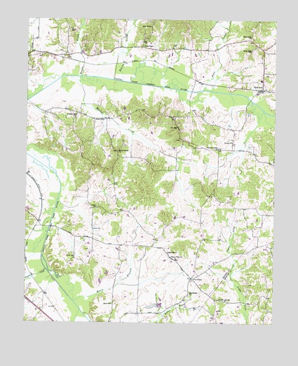
Beech Bluff, TN USGS Topographic Map
Click on map above to begin viewing in our Map Viewer.

This topographic map contains these locations and features:
Feature Name Type Latitude Longitude GNIS ID View Map
Antioch ChurchChurchN35.5748°W88.6467°1275801View Map
Bear CreekStreamN35.5051°W88.7223°1276587View Map
Bear CreekStreamN35.5962°W88.6620°1276588View Map
Beech BluffPopulated PlaceN35.5965°W88.6314°1305050View Map
Beech Bluff ChurchChurchN35.6184°W88.6376°1276792View Map
Beech Bluff Elementary SchoolSchoolN35.6003°W88.6323°1320997View Map
Beech Bluff Post OfficePost OfficeN35.5966°W88.6311°1651634View Map
Beech Bluff SchoolSchoolN35.6126°W88.6373°1276793View Map
Big Springs ChurchChurchN35.5123°W88.6670°1277428View Map
Brown CreekStreamN35.6017°W88.7237°1305446View Map
Commissioner District 8CivilN35.6012°W88.6955°2464688View Map
County Line SchoolSchoolN35.5098°W88.6523°1281389View Map
Diamond Grove ChurchChurchN35.5723°W88.6537°1282416View Map
Five PointsPopulated PlaceN35.5184°W88.6664°1284347View Map
Harris CreekStreamN35.5998°W88.7031°1286979View Map
Hunters CreekStreamN35.5215°W88.7395°1288751View Map
Hurts Chapel Christian Methodist Episcopal ChurchChurchN35.6212°W88.7287°1321024View Map
Hurts SchoolSchoolN35.6212°W88.7289°1288853View Map
Isaac ChapelChurchN35.6226°W88.6887°1289064View Map
Laurel ChurchChurchN35.5476°W88.7148°1290718View Map
Madison County Fire Department Station 15BuildingN35.5873°W88.7416°2654019View Map
Madison County Fire Department Station 4BuildingN35.5963°W88.6308°2654028View Map
Maple GrovePopulated PlaceN35.5842°W88.7162°1315459View Map
Marlin CreekStreamN35.6015°W88.7281°1292707View Map
Mason Wells ChurchChurchN35.5276°W88.6767°1292893View Map
Moore BranchStreamN35.5090°W88.7262°1294239View Map
Moore SchoolSchoolN35.5076°W88.7062°1294304View Map
Pleasant Hill ChurchChurchN35.5856°W88.7256°1297866View Map
Potts ChapelChurchN35.6142°W88.6923°1298369View Map
Rocky Springs ChurchChurchN35.5709°W88.7042°1299934View Map
Southfork AirportAirportN35.6117°W88.6964°2675482View Map
Zion Hill ChurchChurchN35.5809°W88.6751°1275373View Map

Note: Coordinates in the location and feature list above are referenced to NAD83 datum.


Copyright (C) 2008-2025 Ryan Niemi / Sunset Dynamics ... All Rights Reserved