TopoQuest Logo
Do you find TopoQuest useful?
Help keep TopoQuest running and adding new maps/features by donating!
Bitcoin:  19c7KJd3qBynnjoSw5npx9KScwjBe4ifkT
Litecoin:  LXs6TkuXGGXo1vDsWCkWVdjQX94eUKd6ui
Home View Maps Find Maps Find Places Resources & Links


Moscow, Pennsylvania Topographic Map

USGS Map Title: Moscow, PA
USGS Map MRC: 41075C5
DRG (GeoTIFF) Download: o41075c5.tif


Neighboring USGS Topographic Map Quads:


  Scranton, PA  
41075D6
 

  Olyphant, PA  
41075D5
 

  Lake Ariel, PA  
41075D4
 

  Avoca, PA  
41075C6
 

  Moscow, PA  
41075C5
 

  Sterling, PA  
41075C4
 

  Pleasant View Summit, PA  
41075B6
 

  Thornhurst, PA  
41075B5
 

  Tobyhanna, PA  
41075B4


Map MRC Location:

N42°
W76°
N42°
W75°
H8 H7 H6 H5 H4 H3 H2 H1
G8 G7 G6 G5 G4 G3 G2 G1
F8 F7 F6 F5 F4 F3 F2 F1
E8 E7 E6 E5 E4 E3 E2 E1
D8 D7 D6 D5 D4 D3 D2 D1
C8 C7 C6 C5 C4 C3 C2 C1
B8 B7 B6 B5 B4 B3 B2 B1
A8 A7 A6 A5 A4 A3 A2 A1
N41°
W76°
N41°
W75°

Moscow, PA USGS 1:24K Topographic Map Preview:
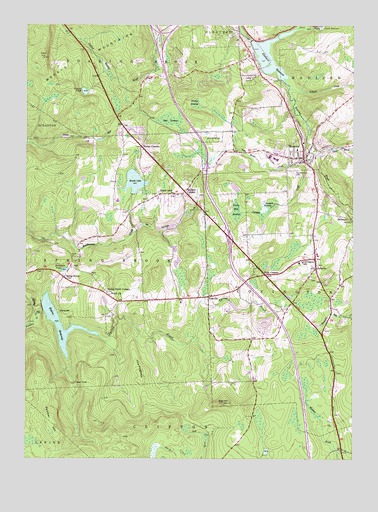
Moscow, PA USGS Topographic Map
Click on map above to begin viewing in our Map Viewer.

This topographic map contains these locations and features:
Feature Name Type Latitude Longitude GNIS ID View Map
Arthur T Howells Middle SchoolSchoolN41.3373°W75.5313°1211712View Map
Bear BrookStreamN41.3395°W75.5141°1168851View Map
Bear SwampSwampN41.3474°W75.5693°1168946View Map
Benjamin PondLakeN41.3044°W75.6099°1169242View Map
Birchwood EstatesPopulated PlaceN41.3579°W75.5782°1201578View Map
Blair HillSummitN41.2662°W75.5488°1169791View Map
Boar HoleBayN41.2717°W75.6060°1169917View Map
Borough of MoscowCivilN41.3417°W75.5315°1215325View Map
Brookhurst EstatesPopulated PlaceN41.3579°W75.5607°1201579View Map
Compton DamDamN41.2917°W75.5463°1195445View Map
Coon HillSummitN41.3656°W75.6180°1172405View Map
Covington Elementary SchoolSchoolN41.3067°W75.5188°1213828View Map
Covington Independent Fire Company Station 14BuildingN41.3065°W75.5170°2652934View Map
CrestwoodPopulated PlaceN41.3548°W75.5652°1201576View Map
Curtis DamDamN41.3748°W75.5131°1195508View Map
DalevillePopulated PlaceN41.3051°W75.5138°1172892View Map
Dawn AcresPopulated PlaceN41.3376°W75.5071°1201693View Map
Elmbrook TerracePopulated PlaceN41.3590°W75.5671°1201577View Map
Elmhurst Country ClubLocaleN41.3531°W75.5471°1205826View Map
Elmhurst Elementary SchoolSchoolN41.3712°W75.5438°1205834View Map
Elmhurst ReservoirReservoirN41.3661°W75.5320°1174177View Map
Elmhurst Roaring Brook Volunteer Fire Company Station 15BuildingN41.3634°W75.5490°2653078View Map
Fairview Memorial EstateCemeteryN41.3604°W75.5394°1174536View Map
Fells CornersPopulated PlaceN41.3031°W75.5330°1174670View Map
Harmony HillsPopulated PlaceN41.3409°W75.5346°1201574View Map
Hazard PondLakeN41.3558°W75.6023°1176708View Map
HollistersPopulated PlaceN41.3187°W75.5002°1203826View Map
Kellum CreekStreamN41.3570°W75.5235°1178331View Map
Langan CreekStreamN41.3351°W75.5182°1178864View Map
Langan SwampSwampN41.3228°W75.5316°1178865View Map
Lazy J Ranch AirportAirportN41.2968°W75.5977°2443027View Map
Maple LakePopulated PlaceN41.3262°W75.5732°1180353View Map
Maple LakeReservoirN41.3298°W75.5833°1180354View Map
Maple Lake DamDamN41.3261°W75.5838°1195476View Map
MoscowPopulated PlaceN41.3367°W75.5185°1181598View Map
Moscow Boro Police DepartmentBuildingN41.3356°W75.5200°2776948View Map
Moscow Elementary SchoolSchoolN41.3392°W75.5210°1211713View Map
Moscow Post OfficePost OfficeN41.3439°W75.5215°2779750View Map
Moscow Volunteer Fire and Hose Company Station 7BuildingN41.3376°W75.5190°2653370View Map
Mullen SwampSwampN41.3533°W75.5596°1182072View Map
North Pocono High SchoolSchoolN41.3365°W75.5291°1211711View Map
Olwen HeightsPopulated PlaceN41.3590°W75.5491°1201580View Map
Panther CreekStreamN41.2917°W75.6205°1183249View Map
Panther HillSummitN41.2595°W75.6130°1183252View Map
Quinlan CornersPopulated PlaceN41.3270°W75.5635°1184564View Map
Roaring Brook Municipal buildingBuildingN41.3626°W75.5602°1205833View Map
RockdalePopulated PlaceN41.2923°W75.6116°1204527View Map
Saint Catherines CemeteryCemeteryN41.3323°W75.5213°1185856View Map
Six Springs CreekStreamN41.3148°W75.5835°1187734View Map
Spring BrookPopulated PlaceN41.3023°W75.6099°1188205View Map
Spring BrookPopulated PlaceN41.2967°W75.5924°1212557View Map
Spring Brook CornersLocaleN41.2984°W75.5941°1188207View Map
Spring Brook Volunteer Fire Company Station 53BuildingN41.3031°W75.6086°2653077View Map
Springbrook Township Municipal BuildingBuildingN41.3356°W75.5746°1205832View Map
Stephen HeightsPopulated PlaceN41.3417°W75.5121°1201575View Map
The HogbackRidgeN41.2754°W75.5805°1189406View Map
Tooley CornersPopulated PlaceN41.3398°W75.5802°1189658View Map
Township of CovingtonCivilN41.2943°W75.5039°1216595View Map
Township of Spring BrookCivilN41.3050°W75.6223°1216610View Map
Union Mill SwampSwampN41.3214°W75.5440°1190165View Map
Van Brunt CreekStreamN41.3392°W75.5141°1200124View Map
Watres DamDamN41.2941°W75.6185°1195451View Map
Watres ReservoirReservoirN41.2890°W75.6117°1190681View Map
Welch ChurchChurchN41.2973°W75.5921°1190795View Map
White Oak RunStreamN41.3742°W75.5210°1193654View Map
YostvillePopulated PlaceN41.2967°W75.5546°1191913View Map

Note: Coordinates in the location and feature list above are referenced to NAD83 datum.


Copyright (C) 2008-2025 Ryan Niemi / Sunset Dynamics ... All Rights Reserved