TopoQuest Logo
Do you find TopoQuest useful?
Help keep TopoQuest running and adding new maps/features by donating!
Bitcoin:  19c7KJd3qBynnjoSw5npx9KScwjBe4ifkT
Litecoin:  LXs6TkuXGGXo1vDsWCkWVdjQX94eUKd6ui
Home View Maps Find Maps Find Places Resources & Links


Pleasant View Summit, Pennsylvania Topographic Map

USGS Map Title: Pleasant View Summit, PA
USGS Map MRC: 41075B6
DRG (GeoTIFF) Download: o41075b6.tif


Neighboring USGS Topographic Map Quads:


  Pittston, PA  
41075C7
 

  Avoca, PA  
41075C6
 

  Moscow, PA  
41075C5
 

  Wilkes-Barre East, PA  
41075B7
 

  Pleasant View Summit, PA  
41075B6
 

  Thornhurst, PA  
41075B5
 

  White Haven, PA  
41075A7
 

  Hickory Run, PA  
41075A6
 

  Blakeslee, PA  
41075A5


Map MRC Location:

N42°
W76°
N42°
W75°
H8 H7 H6 H5 H4 H3 H2 H1
G8 G7 G6 G5 G4 G3 G2 G1
F8 F7 F6 F5 F4 F3 F2 F1
E8 E7 E6 E5 E4 E3 E2 E1
D8 D7 D6 D5 D4 D3 D2 D1
C8 C7 C6 C5 C4 C3 C2 C1
B8 B7 B6 B5 B4 B3 B2 B1
A8 A7 A6 A5 A4 A3 A2 A1
N41°
W76°
N41°
W75°

Pleasant View Summit, PA USGS 1:24K Topographic Map Preview:
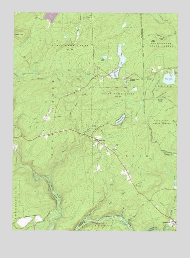
Pleasant View Summit, PA USGS Topographic Map
Click on map above to begin viewing in our Map Viewer.

This topographic map contains these locations and features:
Feature Name Type Latitude Longitude GNIS ID View Map
Bald MountainSummitN41.2381°W75.7452°1168646View Map
Balsam SwampSwampN41.2090°W75.6403°1168676View Map
Bear LakeLakeN41.2127°W75.6309°1168885View Map
Bear SwampSwampN41.2338°W75.6440°1168944View Map
Behler SwampSwampN41.2123°W75.6464°1169131View Map
Big Pine HillSummitN41.2359°W75.6357°1192136View Map
Big Pine Hill ViewLocaleN41.2359°W75.6360°1205717View Map
Choke Creek TrailTrailN41.1868°W75.6446°1205718View Map
Dry Land HillSummitN41.1512°W75.6544°1192372View Map
Dry Land Hill TowerTowerN41.1512°W75.6546°1197944View Map
Francis E Walter ReservoirReservoirN41.1284°W75.7330°1195290View Map
Great Falls of the LehighFallsN41.1293°W75.6271°1201331View Map
Horseshoe SwampSwampN41.1998°W75.6378°1177465View Map
Indian LakeLakeN41.1888°W75.6677°1177762View Map
Indian Lake DamDamN41.1934°W75.6696°1195336View Map
Kendall CreekStreamN41.1376°W75.6266°1178352View Map
Kiel lakeReservoirN41.2358°W75.7102°1202889View Map
Lake AleedaReservoirN41.2467°W75.7163°1195398View Map
Lake AleedaReservoirN41.2483°W75.7240°1212760View Map
Lake Aleeda DamDamN41.2467°W75.7163°1195399View Map
Little Bear CreekStreamN41.2123°W75.7477°1179462View Map
Little Shades CreekStreamN41.1792°W75.6971°1179677View Map
Meadow LakeReservoirN41.2257°W75.6676°1195368View Map
Meadow Lake DamDamN41.2192°W75.6688°1208707View Map
Meadow Lake RunDamN41.2201°W75.6680°1195367View Map
Meadow RunStreamN41.2148°W75.7355°1180831View Map
Meadow Run PondsReservoirN41.2163°W75.6723°1192919View Map
Mountain LakeReservoirN41.2134°W75.6763°1195358View Map
Mountain Lake DamDamN41.2134°W75.6763°1195357View Map
Mud PondReservoirN41.2245°W75.6800°1182018View Map
Mud Run CreekStreamN41.2476°W75.6960°1212548View Map
Pleasant View SummitPopulated PlaceN41.2123°W75.6635°1184096View Map
Pocono SpringSpringN41.1845°W75.6869°1184158View Map
Red Run CreekStreamN41.2298°W75.7207°1212761View Map
Refuge TrailTrailN41.2284°W75.6377°1205716View Map
Shades CreekStreamN41.1548°W75.7224°1187294View Map
Shades Creek Volunteer Fire Company Station 15BuildingN41.1742°W75.6793°2652894View Map
Shades GlenPopulated PlaceN41.1767°W75.6841°1187295View Map
Snider RunStreamN41.2151°W75.7194°1187939View Map
Spring RunStreamN41.1337°W75.6663°1188263View Map
State Game Lands Number 91ParkN41.2001°W75.6663°1208048View Map
StoddartsvillePopulated PlaceN41.1298°W75.6282°1188698View Map
Stoddartsville Post Office (historical)Post OfficeN41.1298°W75.6282°2027096View Map
Stony RunStreamN41.1315°W75.6921°1188798View Map
Township of BuckCivilN41.1648°W75.6552°1216704View Map
Walter Dike Number OneDamN41.1268°W75.7330°1195289View Map
Walter Dike Number TwoDamN41.1284°W75.7330°1195291View Map
White House RunStreamN41.1301°W75.6627°1191285View Map
Wilkes-Barre Golf CourseLocaleN41.1798°W75.7380°1205628View Map

Note: Coordinates in the location and feature list above are referenced to NAD83 datum.


Copyright (C) 2008-2024 Ryan Niemi / Sunset Dynamics ... All Rights Reserved