TopoQuest Logo
Do you find TopoQuest useful?
Help keep TopoQuest running and adding new maps/features by donating!
Bitcoin:  19c7KJd3qBynnjoSw5npx9KScwjBe4ifkT
Litecoin:  LXs6TkuXGGXo1vDsWCkWVdjQX94eUKd6ui
Home View Maps Find Maps Find Places Resources & Links


Mosinee, Wisconsin Topographic Map

USGS Map Title: Mosinee, WI
USGS Map MRC: 44089G6
DRG (GeoTIFF) Download: o44089g6.tif


Neighboring USGS Topographic Map Quads:


  Marathon, WI  
44089H7
 

  Wausau West, WI  
44089H6
 

  Wausau East, WI  
44089H5
 

  Halder, WI  
44089G7
 

  Mosinee, WI  
44089G6
 

  Peplin, WI  
44089G5
 

  Big Eau Pleine Reservoir, WI  
44089F7
 

  Dancy, WI  
44089F6
 

  Dewey Marsh, WI  
44089F5


Map MRC Location:

N45°
W90°
N45°
W89°
H8 H7 H6 H5 H4 H3 H2 H1
G8 G7 G6 G5 G4 G3 G2 G1
F8 F7 F6 F5 F4 F3 F2 F1
E8 E7 E6 E5 E4 E3 E2 E1
D8 D7 D6 D5 D4 D3 D2 D1
C8 C7 C6 C5 C4 C3 C2 C1
B8 B7 B6 B5 B4 B3 B2 B1
A8 A7 A6 A5 A4 A3 A2 A1
N44°
W90°
N44°
W89°

Mosinee, WI USGS 1:24K Topographic Map Preview:
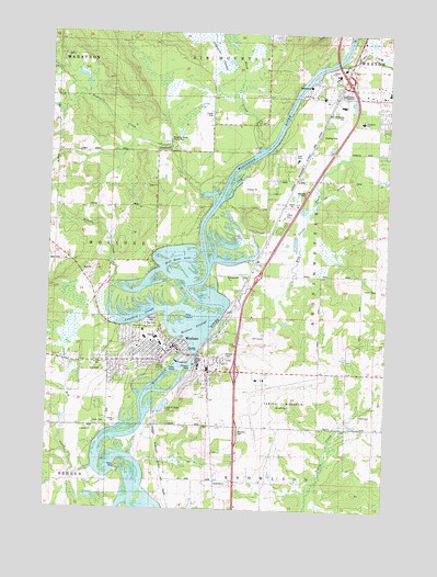
Mosinee, WI USGS Topographic Map
Click on map above to begin viewing in our Map Viewer.

This topographic map contains these locations and features:
Feature Name Type Latitude Longitude GNIS ID View Map
Birch FlowageReservoirN44.8549°W89.7077°2770684View Map
Black CreekStreamN44.8441°W89.6729°1561854View Map
Bull Junior CreekStreamN44.7952°W89.6898°1562392View Map
Cedar CreekStreamN44.8669°W89.6437°1562839View Map
Cemetery SloughStreamN44.8022°W89.7060°1562877View Map
Central Wisconsin AirportAirportN44.7835°W89.6720°1582095View Map
City of MosineeCivilN44.7869°W89.6838°1583757View Map
Crossroads Apostolic Bible ChurchChurchN44.7936°W89.7046°1844087View Map
EvergreenPopulated PlaceN44.8425°W89.6376°1867657View Map
Evergreen Elementary SchoolSchoolN44.8520°W89.6352°1844106View Map
Fellowship Baptist ChurchChurchN44.8264°W89.6596°1844112View Map
Fourmile CreekStreamN44.8294°W89.6896°1565190View Map
Gate of Heaven CemeteryCemeteryN44.8538°W89.6415°1844130View Map
Good News Baptist ChurchChurchN44.8000°W89.7310°1844131View Map
Gooding ParkParkN44.8480°W89.6504°1565628View Map
Half Moon LakeLakeN44.8139°W89.7018°1565972View Map
Hog CreekStreamN44.7602°W89.7329°1566515View Map
Immanuel Lutheran ChurchChurchN44.7958°W89.7237°1844162View Map
Indianhead Golf CourseLocaleN44.7944°W89.6723°1844164View Map
Iron CreekStreamN44.7811°W89.7435°1577362View Map
Joseph Dessert LibraryBuildingN44.7916°W89.7007°1844169View Map
Karl Mathie HouseBuildingN44.7927°W89.6976°1844170View Map
Kronenwetter Police DepartmentBuildingN44.8246°W89.6600°2759968View Map
Kronenwetter Village Fire DepartmentBuildingN44.8245°W89.6606°2696912View Map
Liberty School (historical)SchoolN44.7864°W89.6704°1568024View Map
MosineePopulated PlaceN44.7930°W89.7032°1569769View Map
Mosinee 1893C138 DamDamN44.7908°W89.6962°1792975View Map
Mosinee CemeteryCemeteryN44.7993°W89.7121°1569770View Map
Mosinee Elementary SchoolSchoolN44.7966°W89.7151°1844199View Map
Mosinee Elementary SchoolSchoolN44.7970°W89.7149°1562092View Map
Mosinee Fire DepartmentBuildingN44.7834°W89.7282°2696834View Map
Mosinee FlowageReservoirN44.7974°W89.6990°1569771View Map
Mosinee Flowage 4126ReservoirN44.7916°W89.6968°1792976View Map
Mosinee High SchoolSchoolN44.7947°W89.7094°1844200View Map
Mosinee Lookout TowerTowerN44.7894°W89.6832°1581289View Map
Mosinee Middle SchoolSchoolN44.7940°W89.7084°1844201View Map
Mosinee Police DepartmentBuildingN44.7925°W89.7014°2759666View Map
Mosinee Post OfficePost OfficeN44.7908°W89.7017°2722989View Map
Mosinee Wastewater Treatment PlantLocaleN44.7875°W89.7067°2722979View Map
Northland Lutheran High SchoolSchoolN44.8443°W89.6304°2713179View Map
Our Saviors Catholic ChurchChurchN44.7927°W89.7104°1845220View Map
Paine School (historical)SchoolN44.8508°W89.6290°1876720View Map
Pine IslandIslandN44.8008°W89.7015°1571471View Map
Roberts CreekStreamN44.8083°W89.7226°1572406View Map
Saint James Episcopal ChurchChurchN44.7911°W89.7023°1845249View Map
Saint John Lutheran ChurchChurchN44.7925°W89.7168°1845251View Map
Saint Paul Catholic SchoolSchoolN44.7913°W89.7064°1845273View Map
Saint Paul CemeteryCemeteryN44.7983°W89.7123°1573437View Map
Saint Pauls Catholic ChurchChurchN44.7911°W89.7060°1845272View Map
Shooting Range County ParkParkN44.8483°W89.7085°1845287View Map
Victor School (historical)SchoolN44.7716°W89.6896°1876754View Map
Weston Power PlantBuildingN44.8611°W89.6544°2352368View Map
Wisconsin Valley Lutheran High SchoolSchoolN44.8102°W89.6856°2713217View Map

Note: Coordinates in the location and feature list above are referenced to NAD83 datum.


Copyright (C) 2008-2024 Ryan Niemi / Sunset Dynamics ... All Rights Reserved