TopoQuest Logo
Do you find TopoQuest useful?
Help keep TopoQuest running and adding new maps/features by donating!
Bitcoin:  19c7KJd3qBynnjoSw5npx9KScwjBe4ifkT
Litecoin:  LXs6TkuXGGXo1vDsWCkWVdjQX94eUKd6ui
Home View Maps Find Maps Find Places Resources & Links


Mound, Minnesota Topographic Map

USGS Map Title: Mound, MN
USGS Map MRC: 44093H6
DRG (GeoTIFF) Download: o44093h6.tif


Neighboring USGS Topographic Map Quads:


  Delano, MN  
45093A7
 

  Rockford, MN  
45093A6
 

  Hamel, MN  
45093A5
 

  Watertown, MN  
44093H7
 

  Mound, MN  
44093H6
 

  Excelsior, MN  
44093H5
 

  Waconia, MN  
44093G7
 

  Victoria, MN  
44093G6
 

  Shakopee, MN  
44093G5


Map MRC Location:

N45°
W94°
N45°
W93°
H8 H7 H6 H5 H4 H3 H2 H1
G8 G7 G6 G5 G4 G3 G2 G1
F8 F7 F6 F5 F4 F3 F2 F1
E8 E7 E6 E5 E4 E3 E2 E1
D8 D7 D6 D5 D4 D3 D2 D1
C8 C7 C6 C5 C4 C3 C2 C1
B8 B7 B6 B5 B4 B3 B2 B1
A8 A7 A6 A5 A4 A3 A2 A1
N44°
W94°
N44°
W93°

Mound, MN USGS 1:24K Topographic Map Preview:
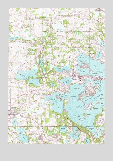
Mound, MN USGS Topographic Map
Click on map above to begin viewing in our Map Viewer.

This topographic map contains these locations and features:
Feature Name Type Latitude Longitude GNIS ID View Map
Bay ParkParkN44.9291°W93.6700°639744View Map
Black LakeLakeN44.9316°W93.6352°640212View Map
Burr Oaks Golf ClubLocaleN44.9750°W93.6650°2104070View Map
Cedar PointCapeN44.9158°W93.6602°641031View Map
Christ Lutheran CemeteryCemeteryN44.9856°W93.6647°2101116View Map
Christmas Tree CampLocaleN44.9452°W93.6833°641201View Map
City of MinnetristaCivilN44.9354°W93.7089°2395352View Map
City of MoundCivilN44.9336°W93.6608°2395111View Map
City of Saint BonifaciusCivilN44.9054°W93.7476°2396475View Map
City of Spring ParkCivilN44.9360°W93.6328°2395935View Map
Commerce Place Shopping CenterLocaleN44.9390°W93.6661°2478614View Map
Cooks BayBayN44.9252°W93.6608°641461View Map
Copeland SchoolSchoolN44.9927°W93.7480°641488View Map
Crane IslandIslandN44.9008°W93.6622°642428View Map
Crown CollegeSchoolN44.8854°W93.7430°645640View Map
Deering IslandIslandN44.9414°W93.6366°642739View Map
Dutch LakeLakeN44.9440°W93.6805°642995View Map
Eagle BluffCliffN44.9177°W93.6866°643008View Map
Eagle IslandIslandN44.8975°W93.6569°643012View Map
Emerald LakeLakeN44.9300°W93.6500°2101640View Map
Emerald Lake BridgeBridgeN44.9292°W93.6514°2101639View Map
Enchanted IslandIslandN44.9083°W93.6458°643370View Map
Fagerness PointCapeN44.9427°W93.6263°643486View Map
Flobacks Seaplane BaseAirportN44.8941°W93.6636°660146View Map
Forest LakeLakeN44.9577°W93.6327°643804View Map
Forest Lake BridgeBridgeN44.9531°W93.6350°2101643View Map
Freshwater Community ChurchChurchN44.8999°W93.7408°2478189View Map
Goose IslandIslandN44.9208°W93.6308°644235View Map
Grandview Middle SchoolSchoolN44.9438°W93.6683°2432818View Map
Halsted BayBayN44.9114°W93.6861°644589View Map
Halsted Bay BridgeBridgeN44.9189°W93.6839°2101637View Map
Halsted Bay BridgeBridgeN44.9189°W93.6839°2101638View Map
Halsted Family CemeteryCemeteryN44.9053°W93.6750°2101114View Map
Hardscrabble PointCapeN44.9186°W93.6702°644663View Map
Harrison BayBayN44.9422°W93.6547°644688View Map
Hennepin County Sheriff's Office - Water PatrolBuildingN44.9348°W93.6276°2758510View Map
Hilltop Primary SchoolSchoolN44.9531°W93.6697°2433221View Map
Homestead OrchardLocaleN44.9969°W93.7247°2663759View Map
Howard PointCapeN44.9094°W93.6288°645262View Map
Island ParkPopulated PlaceN44.9247°W93.6383°645518View Map
Island Park Post Office (historical)Post OfficeN44.9247°W93.6381°2101156View Map
Jennings BayBayN44.9544°W93.6527°645624View Map
Kings PointCapeN44.9155°W93.6947°646166View Map
Kingswood CampLocaleN44.9544°W93.7097°646172View Map
Lake MinnetonkaLakeN44.9150°W93.6413°647954View Map
Lake Minnetonka Regional ParkParkN44.8939°W93.6792°2104068View Map
Lake VirginiaLakeN44.8860°W93.6326°653674View Map
Lake ZumbraLakeN44.8830°W93.6661°654506View Map
Lakeview Golf CourseLocaleN44.9681°W93.6422°2104071View Map
Langdon LakeLakeN44.9331°W93.6748°646478View Map
Long LakeLakeN44.9497°W93.7078°647037View Map
Lunsten LakeReservoirN44.8850°W93.7252°1777103View Map
Lunsten Lake DamDamN44.8850°W93.7252°1777102View Map
LyndalePopulated PlaceN44.9825°W93.7319°647330View Map
Lyndale Post Office (historical)Post OfficeN44.9825°W93.7317°2101158View Map
Lyndale SchoolSchoolN44.9897°W93.7227°647335View Map
Marina Center Shopping CenterLocaleN44.9365°W93.6430°2478701View Map
Minnestrista Merriman CemeteryCemeteryN44.9697°W93.7365°2101115View Map
Minnetonka OrchardsLocaleN44.9761°W93.6911°2663763View Map
MinnetristaPopulated PlaceN44.9383°W93.7177°1669532View Map
Minnetrista Baptist CemeteryCemeteryN44.9054°W93.7354°2100893View Map
Minnetrista Post Office (historical)Post OfficeN44.9383°W93.7175°2101149View Map
Minnetrista Public Safety DepartmentBuildingN44.9231°W93.7182°2758527View Map
MoundPopulated PlaceN44.9366°W93.6661°648143View Map
Mound Fire DepartmentBuildingN44.9342°W93.6585°2666191View Map
Mound Police DepartmentBuildingN44.9342°W93.6585°2758589View Map
Mound Post OfficePost OfficeN44.9382°W93.6640°2776593View Map
Mound Union CemeteryCemeteryN44.9252°W93.6859°648145View Map
Mound Westonka High SchoolSchoolN44.9549°W93.6723°2433239View Map
Mound-Westonka Secondary SchoolSchoolN44.9548°W93.6717°2479166View Map
Mud LakeLakeN44.8945°W93.7418°648222View Map
Our Lady of the Lake Catholic CemeteryCemeteryN44.9519°W93.6663°2100892View Map
Our Lady of the Lake SchoolSchoolN44.9348°W93.6675°2432864View Map
Ox Yoke LakeLakeN44.9722°W93.7471°649098View Map
Painter CreekStreamN44.9586°W93.6577°649118View Map
Parley LakeLakeN44.8823°W93.7309°649169View Map
Peil-Juliar Seaplane BaseAirportN44.9597°W93.6494°660312View Map
Pelican PointCapeN44.9247°W93.6327°649245View Map
Phelps BayBayN44.9169°W93.6466°649350View Map
Phelps IslandIslandN44.9230°W93.6461°649352View Map
Pioneer CreekStreamN44.9730°W93.7419°649516View Map
Priest BayBayN44.9194°W93.6772°649737View Map
Red Oak Golf CourseLocaleN44.9611°W93.6478°2104069View Map
Ridgeview Ambulance Service MinnetristaBuildingN44.9228°W93.7192°2721358View Map
Saga HillPopulated PlaceN44.9547°W93.6400°650468View Map
Saint BonifaciusPopulated PlaceN44.9055°W93.7475°650538View Map
Saint Bonifacius Catholic CemeteryCemeteryN44.9050°W93.7468°2100894View Map
Saint Bonifacius Fire DepartmentBuildingN44.9118°W93.7479°2666126View Map
Saint Bonifacius Post OfficePost OfficeN44.9025°W93.7497°2776595View Map
Schutz LakeLakeN44.8759°W93.6461°651793View Map
Seton BridgeBridgeN44.9367°W93.6442°2101641View Map
Seton LakeLakeN44.9339°W93.6477°651858View Map
Shady IslandIslandN44.9133°W93.6333°651885View Map
Shadywood PointCapeN44.9414°W93.6411°651891View Map
Shirley Hills Primary SchoolSchoolN44.9338°W93.6571°2433134View Map
Shoreline Plaza Shopping CenterLocaleN44.9359°W93.6577°2479413View Map
Sixmile CreekStreamN44.9141°W93.7025°652101View Map
Skogsber PointCapeN44.9525°W93.6425°2101642View Map
Smithtown BayBayN44.8889°W93.6408°652189View Map
Spray IslandIslandN44.9164°W93.6263°652419View Map
Spring ParkPopulated PlaceN44.9352°W93.6322°652482View Map
Spring Park BayBayN44.9291°W93.6272°652483View Map
Spring Park City HallBuildingN44.9357°W93.6326°2478065View Map
Stone LakeLakeN44.8888°W93.6786°652661View Map
Township of Minnetrista (historical)CivilN44.9350°W93.7008°1669535View Map
Wawatosa IslandIslandN44.9019°W93.6500°659770View Map
West ArmBayN44.9486°W93.6416°653925View Map
Whaletail LakeLakeN44.9367°W93.7241°654560View Map
Woodland PointCapeN44.9502°W93.6541°654359View Map
Zimmermans PassChannelN44.9111°W93.6516°654439View Map

Note: Coordinates in the location and feature list above are referenced to NAD83 datum.


Copyright (C) 2008-2024 Ryan Niemi / Sunset Dynamics ... All Rights Reserved