TopoQuest Logo
Do you find TopoQuest useful?
Help keep TopoQuest running and adding new maps/features by donating!
Bitcoin:  19c7KJd3qBynnjoSw5npx9KScwjBe4ifkT
Litecoin:  LXs6TkuXGGXo1vDsWCkWVdjQX94eUKd6ui
Home View Maps Find Maps Find Places Resources & Links


Victoria, Minnesota Topographic Map

USGS Map Title: Victoria, MN
USGS Map MRC: 44093G6
DRG (GeoTIFF) Download: o44093g6.tif


Neighboring USGS Topographic Map Quads:


  Watertown, MN  
44093H7
 

  Mound, MN  
44093H6
 

  Excelsior, MN  
44093H5
 

  Waconia, MN  
44093G7
 

  Victoria, MN  
44093G6
 

  Shakopee, MN  
44093G5
 

  Belle Plaine North, MN  
44093F7
 

  Jordan West, MN  
44093F6
 

  Jordan East, MN  
44093F5


Map MRC Location:

N45°
W94°
N45°
W93°
H8 H7 H6 H5 H4 H3 H2 H1
G8 G7 G6 G5 G4 G3 G2 G1
F8 F7 F6 F5 F4 F3 F2 F1
E8 E7 E6 E5 E4 E3 E2 E1
D8 D7 D6 D5 D4 D3 D2 D1
C8 C7 C6 C5 C4 C3 C2 C1
B8 B7 B6 B5 B4 B3 B2 B1
A8 A7 A6 A5 A4 A3 A2 A1
N44°
W94°
N44°
W93°

Victoria, MN USGS 1:24K Topographic Map Preview:
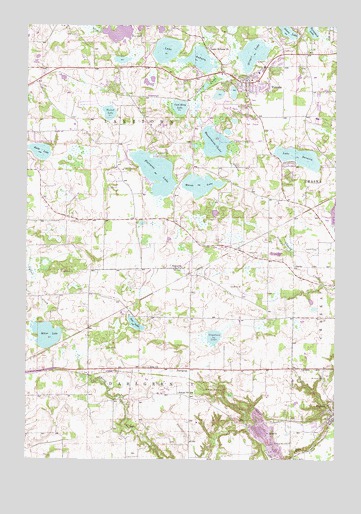
Victoria, MN USGS Topographic Map
Click on map above to begin viewing in our Map Viewer.

This topographic map contains these locations and features:
Feature Name Type Latitude Longitude GNIS ID View Map
Aue LakeLakeN44.7890°W93.7059°639509View Map
AugustaPopulated PlaceN44.8050°W93.6880°639513View Map
AugustaLocaleN44.8050°W93.6878°2094292View Map
Augusta Post Office (historical)Post OfficeN44.8050°W93.6878°2094291View Map
Batzli Wildlife PondReservoirN44.7850°W93.7002°1776437View Map
Carl Krey LakeLakeN44.8516°W93.6885°640895View Map
CarverPopulated PlaceN44.7636°W93.6258°640944View Map
Carver Fire DepartmentBuildingN44.7594°W93.6436°2093444View Map
Carver Post OfficePost OfficeN44.7635°W93.6252°2094284View Map
Chaska Town CornerLocaleN44.8306°W93.6264°2094216View Map
Church LakeLakeN44.8557°W93.6667°2094332View Map
City of CarverCivilN44.7595°W93.6294°2393762View Map
City of VictoriaCivilN44.8634°W93.6586°2397135View Map
Clover Ridge Elementary SchoolSchoolN44.8180°W93.6318°2432852View Map
Dahlgreen Golf ClubLocaleN44.7722°W93.6944°2093424View Map
DahlgrenPopulated PlaceN44.7766°W93.6836°654662View Map
Dahlgren Post Office (historical)Post OfficeN44.7767°W93.6833°2094281View Map
Dahlgren Railroad Station (historical)LocaleN44.7744°W93.6839°2094282View Map
Deardorff OrchardsLocaleN44.8739°W93.7319°2663724View Map
Deer Run Golf ClubLocaleN44.8486°W93.6597°2094330View Map
Elizabeth Batzli Wildlife Pond DamDamN44.7850°W93.7002°1776436View Map
Gaystock LakeLakeN44.7853°W93.6742°659547View Map
German Reformed CemeteryCemeteryN44.7767°W93.7006°2094204View Map
Grace Baptist ChurchChurchN44.7767°W93.6839°2093476View Map
Holy Family Catholic High SchoolSchoolN44.8703°W93.6478°2094329View Map
Kelzer PondLakeN44.8553°W93.6728°2094331View Map
Lake AuburnLakeN44.8652°W93.6803°639503View Map
Lake Auburn ChurchChurchN44.8689°W93.6769°646328View Map
Lake Auburn Moravian CemeteryCemeteryN44.8694°W93.6763°2094259View Map
Lake BavariaLakeN44.8372°W93.6399°639736View Map
Lakeview ClinicHospitalN44.8500°W93.6528°2094328View Map
Marsh LakeLakeN44.8291°W93.6802°647554View Map
Miller LakeLakeN44.7859°W93.7417°647869View Map
Minnesota Valley Baptist SchoolSchoolN44.7768°W93.6836°2479156View Map
Molnau AirparkAirportN44.8436°W93.7400°660452View Map
Mount Hope CemeteryCemeteryN44.7736°W93.6293°648173View Map
Piersons LakeLakeN44.8334°W93.6981°649393View Map
Preiss CemeteryCemeteryN44.7746°W93.6761°2094263View Map
Ray Buesgens Wildlife Pond DamDamN44.8433°W93.6436°1777216View Map
Reitz LakeLakeN44.8388°W93.7463°649926View Map
Saint Nicholas CemeteryCemeteryN44.7550°W93.6433°650923View Map
Saint Victoria Catholic ChurchChurchN44.8547°W93.6611°2094327View Map
Saint Victoria CemeteryCemeteryN44.8553°W93.6616°2094313View Map
School Number 106SchoolN44.7694°W93.6877°651334View Map
Stieger LakeLakeN44.8668°W93.6591°652639View Map
Tamarack LakeLakeN44.8734°W93.6348°653018View Map
Township of Chaska (historical)CivilN44.7969°W93.6275°663785View Map
Township of DahlgrenCivilN44.7623°W93.7074°663913View Map
Township of LaketownCivilN44.8438°W93.7176°664705View Map
Turbid LakeLakeN44.8499°W93.7170°653364View Map
VictoriaPopulated PlaceN44.8586°W93.6616°653650View Map
VictoriaLocaleN44.8639°W93.6592°2094323View Map
Victoria Care CenterHospitalN44.8639°W93.6556°2094325View Map
Victoria City HallBuildingN44.8597°W93.6619°2094326View Map
Victoria Elementary SchoolSchoolN44.8360°W93.6588°2432853View Map
Victoria Fire DepartmentBuildingN44.8590°W93.6563°2094324View Map
Victoria Post OfficePost OfficeN44.8593°W93.6621°2094344View Map
Wassermann LakeLakeN44.8414°W93.6744°659769View Map
Zoar ChurchChurchN44.7766°W93.7005°654502View Map

Note: Coordinates in the location and feature list above are referenced to NAD83 datum.


Copyright (C) 2008-2024 Ryan Niemi / Sunset Dynamics ... All Rights Reserved