TopoQuest Logo
Do you find TopoQuest useful?
Help keep TopoQuest running and adding new maps/features by donating!
Bitcoin:  19c7KJd3qBynnjoSw5npx9KScwjBe4ifkT
Litecoin:  LXs6TkuXGGXo1vDsWCkWVdjQX94eUKd6ui
Home View Maps Find Maps Find Places Resources & Links


Mount Daniel, Washington Topographic Map

USGS Map Title: Mount Daniel, WA
USGS Map MRC: 47121E2
DRG (GeoTIFF) Download: o47121e2.tif


Neighboring USGS Topographic Map Quads:


  Skykomish, WA  
47121F3
 

  Scenic, WA  
47121F2
 

  Stevens Pass, WA  
47121F1
 

  Big Snow Mountain, WA  
47121E3
 

  Mount Daniel, WA  
47121E2
 

  The Cradle, WA  
47121E1
 

  Chikamin Peak, WA  
47121D3
 

  Polallie Ridge, WA  
47121D2
 

  Davis Peak, WA  
47121D1


Map MRC Location:

N48°
W122°
N48°
W121°
H8 H7 H6 H5 H4 H3 H2 H1
G8 G7 G6 G5 G4 G3 G2 G1
F8 F7 F6 F5 F4 F3 F2 F1
E8 E7 E6 E5 E4 E3 E2 E1
D8 D7 D6 D5 D4 D3 D2 D1
C8 C7 C6 C5 C4 C3 C2 C1
B8 B7 B6 B5 B4 B3 B2 B1
A8 A7 A6 A5 A4 A3 A2 A1
N47°
W122°
N47°
W121°

Mount Daniel, WA USGS 1:24K Topographic Map Preview:
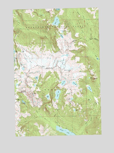
Mount Daniel, WA USGS Topographic Map
Click on map above to begin viewing in our Map Viewer.

This topographic map contains these locations and features:
Feature Name Type Latitude Longitude GNIS ID View Map
Alpine Lakes WildernessReserveN47.5651°W121.1599°1529642View Map
Bears Breast MountainSummitN47.5401°W121.2254°1516304View Map
Blue RidgeRidgeN47.6076°W121.1515°1516714View Map
Cathedral PassGapN47.5522°W121.1311°2088956View Map
Cathedral RockSummitN47.5554°W121.1351°1517499View Map
Chain LakesLakeN47.5581°W121.2399°1517606View Map
Chief CreekStreamN47.5176°W121.2101°1517692View Map
Circle LakeLakeN47.5506°W121.1637°1517786View Map
Deadhead LakeLakeN47.5245°W121.1646°1518538View Map
Deception PassGapN47.5943°W121.1407°1518568View Map
Deep LakeLakeN47.5454°W121.1417°1518599View Map
Deer LakesLakeN47.5347°W121.1413°1518640View Map
Dutch Miller GapGapN47.5357°W121.2437°1519026View Map
Escondido RidgeRidgeN47.5068°W121.2416°2546905View Map
Hinman GlacierGlacierN47.5747°W121.2288°1520819View Map
Hyas LakeLakeN47.5745°W121.1292°1521108View Map
Jade LakeLakeN47.5974°W121.1805°1531470View Map
La Bohn GapGapN47.5623°W121.2373°1521794View Map
La Bohn LakesLakeN47.5672°W121.2387°1521795View Map
Lake ClariceLakeN47.6249°W121.1852°1517802View Map
Lake IvanhoeLakeN47.5338°W121.2383°1521279View Map
Lake LepulLakeN47.5833°W121.2388°1522029View Map
Lake RebeccaLakeN47.5498°W121.2216°1524918View Map
Lake RowenaLakeN47.5570°W121.2184°1525258View Map
Lake VicenteLakeN47.5357°W121.1679°1527706View Map
Lynch GlacierGlacierN47.5722°W121.1805°1522605View Map
Marmot LakeLakeN47.6121°W121.1882°1522742View Map
Mount DanielSummitN47.5626°W121.1720°1518479View Map
Mount HinmanSummitN47.5682°W121.2115°1520820View Map
No Name LakeLakeN47.6022°W121.1799°1523694View Map
Peggys PondLakeN47.5562°W121.1416°1524305View Map
Shovel CreekStreamN47.5215°W121.2168°1525711View Map
Shovel LakeLakeN47.5383°W121.2028°1525714View Map
Spade CreekStreamN47.5151°W121.1995°1526327View Map
Spade LakeLakeN47.5405°W121.1885°1526328View Map
Terrace LakesLakeN47.6186°W121.2068°1527013View Map
Terrace MountainSummitN47.6218°W121.1965°1527014View Map
Venus LakeLakeN47.5516°W121.1799°1527697View Map
Waptus LakeLakeN47.5034°W121.1780°1527796View Map
Williams LakeLakeN47.5507°W121.2476°1528175View Map

Note: Coordinates in the location and feature list above are referenced to NAD83 datum.


Copyright (C) 2008-2025 Ryan Niemi / Sunset Dynamics ... All Rights Reserved