TopoQuest Logo
Do you find TopoQuest useful?
Help keep TopoQuest running and adding new maps/features by donating!
Bitcoin:  19c7KJd3qBynnjoSw5npx9KScwjBe4ifkT
Litecoin:  LXs6TkuXGGXo1vDsWCkWVdjQX94eUKd6ui
Home View Maps Find Maps Find Places Resources & Links


Davis Peak, Washington Topographic Map

USGS Map Title: Davis Peak, WA
USGS Map MRC: 47121D1
DRG (GeoTIFF) Download: o47121d1.tif


Neighboring USGS Topographic Map Quads:


  Mount Daniel, WA  
47121E2
 

  The Cradle, WA  
47121E1
 

  Jack Ridge, WA  
47120E8
 

  Polallie Ridge, WA  
47121D2
 

  Davis Peak, WA  
47121D1
 

  Mount Stuart, WA  
47120D8
 

  Kachess Lake, WA  
47121C2
 

  Cle Elum Lake, WA  
47121C1
 

  Teanaway Butte, WA  
47120C8


Map MRC Location:

N48°
W122°
N48°
W121°
H8 H7 H6 H5 H4 H3 H2 H1
G8 G7 G6 G5 G4 G3 G2 G1
F8 F7 F6 F5 F4 F3 F2 F1
E8 E7 E6 E5 E4 E3 E2 E1
D8 D7 D6 D5 D4 D3 D2 D1
C8 C7 C6 C5 C4 C3 C2 C1
B8 B7 B6 B5 B4 B3 B2 B1
A8 A7 A6 A5 A4 A3 A2 A1
N47°
W122°
N47°
W121°

Davis Peak, WA USGS 1:24K Topographic Map Preview:
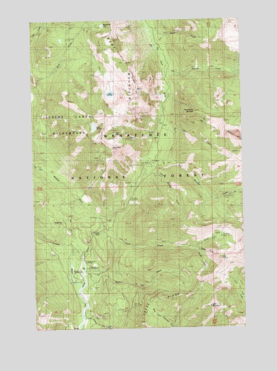
Davis Peak, WA USGS Topographic Map
Click on map above to begin viewing in our Map Viewer.

This topographic map contains these locations and features:
Feature Name Type Latitude Longitude GNIS ID View Map
Big Boulder CreekStreamN47.4423°W121.0587°1516468View Map
Camp CreekStreamN47.4593°W121.0495°1517262View Map
Cayuse CampgroundLocaleN47.3996°W121.0937°1528716View Map
China PointCliffN47.4132°W121.0906°1517722View Map
Cooper RiverStreamN47.3907°W121.1009°1518061View Map
Davis PeakSummitN47.4473°W121.0798°1518510View Map
Davis Peak LookoutLocaleN47.4479°W121.0787°1530116View Map
Davis Peak Lookout TrailTrailN47.4329°W121.0851°1518512View Map
Elsnor MineMineN47.4237°W121.0045°1519318View Map
Fortune CreekStreamN47.4768°W121.0476°1519709View Map
Goat MountainSummitN47.4851°W121.0731°1520048View Map
Hawkins MountainSummitN47.4502°W121.0013°1520613View Map
Hour CreekStreamN47.4396°W121.1198°1520983View Map
Hour Creek CampgroundLocaleN47.4401°W121.1193°1529414View Map
Huckleberry MountainSummitN47.4629°W121.0298°1521032View Map
Jolly MountainSummitN47.3837°W121.0220°1521451View Map
Jolly Mountain LookoutLocaleN47.3837°W121.0218°1530152View Map
Jolly Mountain Lookout TrailTrailN47.3971°W121.0470°1521452View Map
Lake Michael TrailTrailN47.4832°W121.0887°1521854View Map
Lake TerenceLakeN47.4568°W121.0895°1527011View Map
Little Boulder CreekStreamN47.4373°W121.0618°1522167View Map
Little Salmon la SacRapidsN47.3832°W121.0979°1528584View Map
Little Salmon la SacLocaleN47.3840°W121.0970°1529415View Map
Little Salmon la Sac CreekStreamN47.3790°W121.0973°1522299View Map
Michael LakeLakeN47.4701°W121.0794°1523044View Map
Middle Fork Paris CreekStreamN47.4068°W121.0306°1523079View Map
Moonshine LakeLakeN47.4978°W121.0829°1528717View Map
North Fork Paris CreekStreamN47.4073°W121.0306°1523817View Map
Opal LakeLakeN47.4540°W121.0769°1524065View Map
Paris CreekStreamN47.4159°W121.0840°1524198View Map
Red Mountain TrailTrailN47.4029°W121.1181°1524950View Map
Salmon la SacRapidsN47.4040°W121.0970°1528605View Map
Salmon la SacLocaleN47.4057°W121.0973°1529416View Map
Salmon La SacLakeN47.3990°W121.0962°1531336View Map
Salmon la Sac CampgroundLocaleN47.4009°W121.1001°1528718View Map
Salmon la Sac CreekStreamN47.3984°W121.0970°1525383View Map
Salmon la Sac Forest Service StationLocaleN47.4021°W121.0968°1525384View Map
Silver CreekStreamN47.4951°W121.0534°1525754View Map
South Fork Fortune CreekStreamN47.4776°W121.0009°1526194View Map
South Fork Paris CreekStreamN47.4073°W121.0309°1526227View Map
Waptus RiverStreamN47.4193°W121.0879°1527799View Map

Note: Coordinates in the location and feature list above are referenced to NAD83 datum.


Copyright (C) 2008-2025 Ryan Niemi / Sunset Dynamics ... All Rights Reserved