TopoQuest Logo
Do you find TopoQuest useful?
Help keep TopoQuest running and adding new maps/features by donating!
Bitcoin:  19c7KJd3qBynnjoSw5npx9KScwjBe4ifkT
Litecoin:  LXs6TkuXGGXo1vDsWCkWVdjQX94eUKd6ui
Home View Maps Find Maps Find Places Resources & Links


Mount Goddard, California Topographic Map

USGS Map Title: Mount Goddard, CA
USGS Map MRC: 37118A6
DRG (GeoTIFF) Download: o37118a6.tif


Neighboring USGS Topographic Map Quads:


  Mount Henry, CA  
37118B7
 

  Mount Darwin, CA  
37118B6
 

  Mount Thompson, CA  
37118B5
 

  Blackcap Mountain, CA  
37118A7
 

  Mount Goddard, CA  
37118A6
 

  North Palisade, CA  
37118A5
 

  Tehipite Dome, CA  
36118H7
 

  Slide Bluffs, CA  
36118H6
 

  Marion Peak, CA  
36118H5


Map MRC Location:

N38°
W119°
N38°
W118°
H8 H7 H6 H5 H4 H3 H2 H1
G8 G7 G6 G5 G4 G3 G2 G1
F8 F7 F6 F5 F4 F3 F2 F1
E8 E7 E6 E5 E4 E3 E2 E1
D8 D7 D6 D5 D4 D3 D2 D1
C8 C7 C6 C5 C4 C3 C2 C1
B8 B7 B6 B5 B4 B3 B2 B1
A8 A7 A6 A5 A4 A3 A2 A1
N37°
W119°
N37°
W118°

Mount Goddard, CA USGS 1:24K Topographic Map Preview:
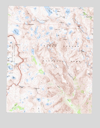
Mount Goddard, CA USGS Topographic Map
Click on map above to begin viewing in our Map Viewer.

This topographic map contains these locations and features:
Feature Name Type Latitude Longitude GNIS ID View Map
Battalion LakeLakeN37.0572°W118.7397°256592View Map
Black DivideRidgeN37.1022°W118.6487°257114View Map
Black GiantSummitN37.1022°W118.6487°257117View Map
Blue Canyon PeakSummitN37.0283°W118.7094°257230View Map
Cathedral LakeLakeN37.0406°W118.7410°258078View Map
Chapel LakeLakeN37.0460°W118.7474°258206View Map
CharybdisSummitN37.0869°W118.6682°258225View Map
Disappearing CreekStreamN37.0149°W118.6604°259387View Map
Enchanted GorgeValleyN37.0154°W118.6582°259930View Map
Eve LakeLakeN37.0642°W118.7484°259990View Map
Finger PeakSummitN37.0298°W118.7303°260110View Map
Goddard DivideRidgeN37.1029°W118.7199°260630View Map
Helen LakeLakeN37.1193°W118.6637°261233View Map
Ionian BasinBasinN37.0933°W118.6793°261799View Map
Kettle RidgeRidgeN37.0325°W118.7432°226548View Map
Lake McDermandLakeN37.1196°W118.6809°263334View Map
Le Conte DivideRidgeN37.0888°W118.7499°266901View Map
Martha LakeLakeN37.0946°W118.7386°263232View Map
Mount GoddardSummitN37.1029°W118.7199°260631View Map
Mount Hansen (not official)SummitN37.0738°W118.6922°2771963View Map
Mount McDuffieSummitN37.0735°W118.6439°263340View Map
Mount ReinsteinSummitN37.0794°W118.7384°265367View Map
Mount SolomonsSummitN37.1065°W118.6742°267388View Map
Muir PassGapN37.1116°W118.6707°263951View Map
Pearl LakeLakeN37.0528°W118.7472°264600View Map
Ragged SpurRidgeN37.0738°W118.6920°265131View Map
Regiment LakeLakeN37.0598°W118.7464°1667367View Map
ScyllaSummitN37.0801°W118.6897°265953View Map
The Three SirensSummitN37.0805°W118.6854°1659989View Map
Tunemah LakeLakeN37.0155°W118.7037°268467View Map
Valor LakeLakeN37.0818°W118.7456°268663View Map
Wanda LakeLakeN37.1212°W118.6925°268772View Map
Wheel MountainSummitN37.0467°W118.6295°268957View Map
White DivideRidgeN37.0701°W118.7340°268997View Map

Note: Coordinates in the location and feature list above are referenced to NAD83 datum.


Copyright (C) 2008-2024 Ryan Niemi / Sunset Dynamics ... All Rights Reserved