TopoQuest Logo
Do you find TopoQuest useful?
Help keep TopoQuest running and adding new maps/features by donating!
Bitcoin:  19c7KJd3qBynnjoSw5npx9KScwjBe4ifkT
Litecoin:  LXs6TkuXGGXo1vDsWCkWVdjQX94eUKd6ui
Home View Maps Find Maps Find Places Resources & Links


Mount Grant, Montana Topographic Map

USGS Map Title: Mount Grant, MT
USGS Map MRC: 48113C7
DRG (GeoTIFF) Download: o48113c7.tif


Neighboring USGS Topographic Map Quads:


  West Glacier, MT  
48113D8
 

  Nyack, MT  
48113D7
 

  Stanton Lake, MT  
48113D6
 

  Nyack SW, MT  
48113C8
 

  Mount Grant, MT  
48113C7
 

  Pinnacle, MT  
48113C6
 

  Jewel Basin, MT  
48113B8
 

  Pioneer Ridge, MT  
48113B7
 

  Felix Peak, MT  
48113B6


Map MRC Location:

N49°
W114°
N49°
W113°
H8 H7 H6 H5 H4 H3 H2 H1
G8 G7 G6 G5 G4 G3 G2 G1
F8 F7 F6 F5 F4 F3 F2 F1
E8 E7 E6 E5 E4 E3 E2 E1
D8 D7 D6 D5 D4 D3 D2 D1
C8 C7 C6 C5 C4 C3 C2 C1
B8 B7 B6 B5 B4 B3 B2 B1
A8 A7 A6 A5 A4 A3 A2 A1
N48°
W114°
N48°
W113°

Mount Grant, MT USGS 1:24K Topographic Map Preview:
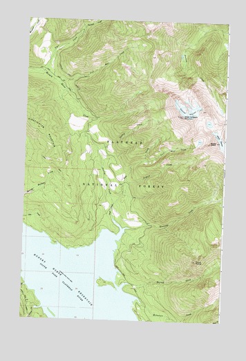
Mount Grant, MT USGS Topographic Map
Click on map above to begin viewing in our Map Viewer.

This topographic map contains these locations and features:
Feature Name Type Latitude Longitude GNIS ID View Map
Dudley CreekStreamN48.2986°W113.8190°782682View Map
Elya CreekStreamN48.2641°W113.8721°783171View Map
Flossy CreekStreamN48.2541°W113.8668°783557View Map
Grant GlacierGlacierN48.3233°W113.7518°784185View Map
Grant RidgeRidgeN48.3247°W113.7559°784186View Map
Great Northern MountainSummitN48.3358°W113.7771°784260View Map
Kelly IslandIslandN48.2652°W113.8218°794206View Map
Lost Hair CreekStreamN48.3172°W113.8004°773695View Map
Lost Mare CreekStreamN48.3489°W113.8557°786622View Map
McInernie CreekStreamN48.2572°W113.8004°787067View Map
Mount GrantSummitN48.3247°W113.7559°784188View Map
Mount MurraySummitN48.2755°W113.7671°787880View Map
Murray Bay CampgroundLocaleN48.2669°W113.8134°799042View Map
Murray CreekStreamN48.2652°W113.8082°787876View Map
Riverside BayBayN48.2825°W113.8209°794209View Map
Riverside Boat LandingLocaleN48.2714°W113.8162°798899View Map
Riverside CreekStreamN48.2883°W113.8090°789611View Map
Ryle CreekStreamN48.2986°W113.8190°789881View Map
Seagrid CreekStreamN48.3019°W113.8143°790170View Map
Stanton GlacierGlacierN48.3369°W113.7748°791433View Map
Tent CreekStreamN48.2927°W113.8193°791966View Map
Tiger CreekStreamN48.3530°W113.8651°792170View Map
Turmoil CreekStreamN48.3708°W113.8412°792469View Map

Note: Coordinates in the location and feature list above are referenced to NAD83 datum.


Copyright (C) 2008-2025 Ryan Niemi / Sunset Dynamics ... All Rights Reserved