TopoQuest Logo
Do you find TopoQuest useful?
Help keep TopoQuest running and adding new maps/features by donating!
Bitcoin:  19c7KJd3qBynnjoSw5npx9KScwjBe4ifkT
Litecoin:  LXs6TkuXGGXo1vDsWCkWVdjQX94eUKd6ui
Home View Maps Find Maps Find Places Resources & Links


Mount Hebgen, Montana Topographic Map

USGS Map Title: Mount Hebgen, MT
USGS Map MRC: 44111G2
DRG (GeoTIFF) Download: o44111g2.tif


Neighboring USGS Topographic Map Quads:


  Pika Point, MT  
44111H3
 

  Upper Tepee Basin, MT  
44111H2
 

  Divide Lake, WY  
44111H1
 

  Hebgen Dam, MT  
44111G3
 

  Mount Hebgen, MT  
44111G2
 

  Richards Creek, MT  
44111G1
 

  Targhee Pass, ID  
44111F3
 

  Madison Arm, MT  
44111F2
 

  West Yellowstone, MT  
44111F1


Map MRC Location:

N45°
W112°
N45°
W111°
H8 H7 H6 H5 H4 H3 H2 H1
G8 G7 G6 G5 G4 G3 G2 G1
F8 F7 F6 F5 F4 F3 F2 F1
E8 E7 E6 E5 E4 E3 E2 E1
D8 D7 D6 D5 D4 D3 D2 D1
C8 C7 C6 C5 C4 C3 C2 C1
B8 B7 B6 B5 B4 B3 B2 B1
A8 A7 A6 A5 A4 A3 A2 A1
N44°
W112°
N44°
W111°

Mount Hebgen, MT USGS 1:24K Topographic Map Preview:
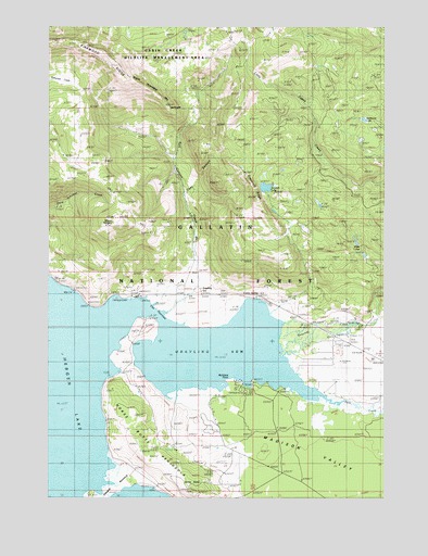
Mount Hebgen, MT USGS Topographic Map
Click on map above to begin viewing in our Map Viewer.

This topographic map contains these locations and features:
Feature Name Type Latitude Longitude GNIS ID View Map
12S04E11BDDC01 WellWellN44.8033°W111.2069°807213View Map
12S04E12BCBB01 WellWellN44.8055°W111.1941°807215View Map
12S04E25ACDD01 WellWellN44.7594°W111.1802°807208View Map
12S05E17BDAA01 WellWellN44.7910°W111.1447°807212View Map
Basin-Grayling School (historical)SchoolN44.7971°W111.1908°1738052View Map
Coal CanyonValleyN44.8294°W111.1999°781431View Map
Corey SpringSpringN44.8033°W111.1724°781669View Map
Cougar CreekStreamN44.7734°W111.1257°800636View Map
Duck CreekStreamN44.7774°W111.1499°800721View Map
Edwards PeninsulaCapeN44.7527°W111.2258°782997View Map
Edwards PointCapeN44.7555°W111.2236°794449View Map
Graycroft RidgeRidgeN44.8291°W111.1730°784244View Map
GraylingPopulated PlaceN44.8055°W111.1944°784246View Map
Grayling ArmBayN44.7877°W111.1844°784247View Map
Grayling CreekStreamN44.7866°W111.1633°800881View Map
Grayling Post Office (historical)Post OfficeN44.8055°W111.1938°1743796View Map
Hebgen LakeReservoirN44.7821°W111.2335°784702View Map
Hebgen Lake Estates Census Designated PlaceCensusN44.7692°W111.1905°2583814View Map
Horse ButteSummitN44.7513°W111.1947°785021View Map
Horse Butte Acres Trailer CourtPopulated PlaceN44.7583°W111.1841°1738006View Map
Horse Butte PeninsulaCapeN44.7671°W111.2166°785022View Map
Johnson LakeLakeN44.8324°W111.1700°785538View Map
Kirkwood RidgeRidgeN44.8694°W111.2383°778781View Map
KRGS-FM (West Yellowstone)TowerN44.7510°W111.1933°806718View Map
LakeviewPopulated PlaceN44.8046°W111.2408°785929View Map
Little Tepee Creek TrailTrailN44.8299°W111.1591°786374View Map
Mount HebgenSummitN44.8233°W111.2274°767997View Map
Northside Rural Fire DistrictBuildingN44.7913°W111.1413°2546718View Map
Parade Rest RanchLocaleN44.7971°W111.1369°788620View Map
Rainbow PointCapeN44.7827°W111.1827°789347View Map
Rainbow Point CampgroundLocaleN44.7788°W111.1799°794450View Map
Rathbone LakeLakeN44.8504°W111.1334°789394View Map
Red Canyon CreekStreamN44.7991°W111.2074°789444View Map
Red Canyon FaultValleyN44.8449°W111.2024°801930View Map
The NarrowsChannelN44.7994°W111.2124°792042View Map
West Yellowstone DivisionCivilN44.8323°W111.2229°1940739View Map
Whits LakesLakeN44.8178°W111.1362°793256View Map

Note: Coordinates in the location and feature list above are referenced to NAD83 datum.


Copyright (C) 2008-2025 Ryan Niemi / Sunset Dynamics ... All Rights Reserved