TopoQuest Logo
Do you find TopoQuest useful?
Help keep TopoQuest running and adding new maps/features by donating!
Bitcoin:  19c7KJd3qBynnjoSw5npx9KScwjBe4ifkT
Litecoin:  LXs6TkuXGGXo1vDsWCkWVdjQX94eUKd6ui
Home View Maps Find Maps Find Places Resources & Links


Hebgen Dam, Montana Topographic Map

USGS Map Title: Hebgen Dam, MT
USGS Map MRC: 44111G3
DRG (GeoTIFF) Download: o44111g3.tif


Neighboring USGS Topographic Map Quads:


  Hilgard Peak, MT  
44111H4
 

  Pika Point, MT  
44111H3
 

  Upper Tepee Basin, MT  
44111H2
 

  Earthquake Lake, MT  
44111G4
 

  Hebgen Dam, MT  
44111G3
 

  Mount Hebgen, MT  
44111G2
 

  Targhee Peak, ID  
44111F4
 

  Targhee Pass, ID  
44111F3
 

  Madison Arm, MT  
44111F2


Map MRC Location:

N45°
W112°
N45°
W111°
H8 H7 H6 H5 H4 H3 H2 H1
G8 G7 G6 G5 G4 G3 G2 G1
F8 F7 F6 F5 F4 F3 F2 F1
E8 E7 E6 E5 E4 E3 E2 E1
D8 D7 D6 D5 D4 D3 D2 D1
C8 C7 C6 C5 C4 C3 C2 C1
B8 B7 B6 B5 B4 B3 B2 B1
A8 A7 A6 A5 A4 A3 A2 A1
N44°
W112°
N44°
W111°

Hebgen Dam, MT USGS 1:24K Topographic Map Preview:
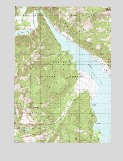
Hebgen Dam, MT USGS Topographic Map
Click on map above to begin viewing in our Map Viewer.

This topographic map contains these locations and features:
Feature Name Type Latitude Longitude GNIS ID View Map
12S04E05ADDC01 WellWellN44.8177°W111.2580°807216View Map
Beaver CreekStreamN44.8524°W111.3641°779597View Map
Beaver Creek CampgroundLocaleN44.8569°W111.3736°794829View Map
Building Destruction Point of InterestLocaleN44.8549°W111.3258°794828View Map
Cabin CreekStreamN44.8694°W111.3450°780729View Map
Cabin Creek CampgroundLocaleN44.8710°W111.3413°780734View Map
Campfire LodgeLocaleN44.8691°W111.3463°780872View Map
Clark Springs GroupLocaleN44.8394°W111.3163°781326View Map
Coffin CreekStreamN44.7658°W111.3208°781475View Map
Coffin LakeLakeN44.7612°W111.3587°781476View Map
Coffin MountainSummitN44.7774°W111.3636°781477View Map
Dave Johnson CreekStreamN44.8149°W111.2600°782094View Map
Halford CampLocaleN44.8524°W111.3625°784471View Map
Hebgen DamDamN44.8637°W111.3356°784701View Map
Hebgen ReservoirReservoirN44.8649°W111.3475°795112View Map
Hebgen RidgeRidgeN44.8463°W111.2922°784703View Map
Hilgard LodgeLocaleN44.8527°W111.3233°784888View Map
Kirkwood CreekStreamN44.8421°W111.3044°785772View Map
Lake Hebgen LodgeLocaleN44.8199°W111.2544°785915View Map
Moonlight CreekStreamN44.8241°W111.3027°787611View Map
North Fork Kirkwood CreekStreamN44.8516°W111.2994°788193View Map
Rumbaugh CampgroundLocaleN44.7574°W111.2722°789847View Map
Rumbaugh CreekStreamN44.7613°W111.2713°789848View Map
Rumbaugh RidgeRidgeN44.7730°W111.2763°806266View Map
Ruof DitchCanalN44.8083°W111.2908°789863View Map
Spring Creek CampgroundLocaleN44.7846°W111.2750°801821View Map
Trapper CreekStreamN44.8346°W111.3133°792335View Map
Upper Coffin LakeLakeN44.7632°W111.3667°792622View Map
Wally McClure CreekStreamN44.8041°W111.2941°2612064View Map
Watkins CreekStreamN44.8094°W111.2747°792881View Map
Watkins Creek RanchLocaleN44.8138°W111.2908°792882View Map
West Fork Trapper CreekStreamN44.8244°W111.3247°793090View Map
West Fork Watkins CreekStreamN44.7699°W111.3158°793098View Map

Note: Coordinates in the location and feature list above are referenced to NAD83 datum.


Copyright (C) 2008-2025 Ryan Niemi / Sunset Dynamics ... All Rights Reserved