TopoQuest Logo
Do you find TopoQuest useful?
Help keep TopoQuest running and adding new maps/features by donating!
Bitcoin:  19c7KJd3qBynnjoSw5npx9KScwjBe4ifkT
Litecoin:  LXs6TkuXGGXo1vDsWCkWVdjQX94eUKd6ui
Home View Maps Find Maps Find Places Resources & Links


Mount Joy, Tennessee Topographic Map

USGS Map Title: Mount Joy, TN
USGS Map MRC: 35087E3
DRG (GeoTIFF) Download: o35087e3.tif


Neighboring USGS Topographic Map Quads:


  Sunrise, TN  
35087F4
 

  Greenfield Bend, TN  
35087F3
 

  Williamsport, TN  
35087F2
 

  Gordonsburg, TN  
35087E4
 

  Mount Joy, TN  
35087E3
 

  Mount Pleasant, TN  
35087E2
 

  Henryville, TN  
35087D4
 

  Summertown, TN  
35087D3
 

  Sandy Hook, TN  
35087D2


Map MRC Location:

N36°
W88°
N36°
W87°
H8 H7 H6 H5 H4 H3 H2 H1
G8 G7 G6 G5 G4 G3 G2 G1
F8 F7 F6 F5 F4 F3 F2 F1
E8 E7 E6 E5 E4 E3 E2 E1
D8 D7 D6 D5 D4 D3 D2 D1
C8 C7 C6 C5 C4 C3 C2 C1
B8 B7 B6 B5 B4 B3 B2 B1
A8 A7 A6 A5 A4 A3 A2 A1
N35°
W88°
N35°
W87°

Mount Joy, TN USGS 1:24K Topographic Map Preview:
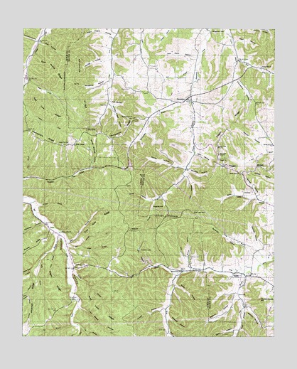
Mount Joy, TN USGS Topographic Map
Click on map above to begin viewing in our Map Viewer.

This topographic map contains these locations and features:
Feature Name Type Latitude Longitude GNIS ID View Map
AethraPopulated PlaceN35.5612°W87.3242°1314565View Map
Akin HollowValleyN35.5740°W87.2899°1275517View Map
Aleck Pogue HollowValleyN35.6214°W87.3308°1304789View Map
Aunt Lude RidgeRidgeN35.5106°W87.3367°1275982View Map
BachelderPopulated PlaceN35.5429°W87.3211°1314614View Map
Bailey CemeteryCemeteryN35.5170°W87.2678°1276100View Map
Baptist BranchStreamN35.5984°W87.2914°1276269View Map
Barker HollowValleyN35.5586°W87.2585°1276311View Map
Barr HollowValleyN35.6190°W87.3671°1276376View Map
Barr Hollow BranchStreamN35.6187°W87.3672°1309363View Map
Bates CreekStreamN35.6098°W87.3733°1647745View Map
Beckum HollowValleyN35.5161°W87.2692°1276746View Map
Beckum Hollow BranchStreamN35.5176°W87.2678°1313212View Map
Beech Hill CemeteryCemeteryN35.5662°W87.2670°1646127View Map
Beech Hill ChurchChurchN35.5662°W87.2670°1305067View Map
Bell BranchStreamN35.5373°W87.3531°1276903View Map
Bell BranchStreamN35.6084°W87.2886°1276904View Map
Betts HollowValleyN35.6099°W87.3741°1277193View Map
Bingham HillSummitN35.6231°W87.2783°1277484View Map
Buckner CemeteryCemeteryN35.5731°W87.2570°1646150View Map
Caney HollowValleyN35.5555°W87.3136°1279582View Map
Cedar Hill CemeteryCemeteryN35.6087°W87.2567°1646162View Map
Cedar Hill ChurchChurchN35.6098°W87.2564°1280068View Map
Church House HillSummitN35.5145°W87.2572°1280549View Map
Commissioner District 1CivilN35.5085°W87.3534°2464256View Map
Conner CemeteryCemeteryN35.6031°W87.2870°1646183View Map
Cooper HollowValleyN35.5111°W87.3040°1281208View Map
Cothran HillSummitN35.5279°W87.3458°1281349View Map
Cox BranchStreamN35.5042°W87.3467°1306157View Map
Cox HollowValleyN35.5654°W87.2942°1281506View Map
Cox Low GapGapN35.5501°W87.2903°1281510View Map
Dickson CemeteryCemeteryN35.5242°W87.2645°1646197View Map
Dickson SpringSpringN35.5249°W87.2672°1306345View Map
District 15 (historical)CivilN35.6001°W87.2917°1310224View Map
District 16 (historical)CivilN35.6084°W87.2917°1310225View Map
District 2 (historical)CivilN35.6084°W87.3000°1310211View Map
Dog BranchStreamN35.5259°W87.2647°1306371View Map
Dry Fork School (historical)SchoolN35.6179°W87.3142°1323687View Map
Eagle FallsFallsN35.5309°W87.3145°1309396View Map
Eagle Falls Church (historical)ChurchN35.5292°W87.3092°1309397View Map
East Fork Curry BranchStreamN35.6120°W87.2681°1283338View Map
East Prong Catheys CreekStreamN35.6037°W87.3720°1283392View Map
East Prong RidgeRidgeN35.6084°W87.3620°1283398View Map
Estes BranchStreamN35.5376°W87.3545°1283859View Map
Five Acre RidgeRidgeN35.5470°W87.3367°1284341View Map
Flat BranchStreamN35.5642°W87.3736°1284365View Map
Fox LakeReservoirN35.5690°W87.3417°1284787View Map
George Pogue HollowValleyN35.5937°W87.3313°1306474View Map
Goat Hollow BranchStreamN35.5745°W87.2528°1313224View Map
Gum SpringSpringN35.5839°W87.3432°1286417View Map
Hamilton LakesReservoirN35.5355°W87.3172°1286663View Map
HampshirePopulated PlaceN35.5967°W87.2931°1306538View Map
Hampshire Baptist ChurchChurchN35.5956°W87.2936°1646252View Map
Hampshire Fire Department Station 5BuildingN35.5966°W87.2940°2653870View Map
Hampshire Post OfficePost OfficeN35.5965°W87.2938°1652223View Map
Hampshire RidgeRidgeN35.5776°W87.3425°1269620View Map
Hampshire SchoolSchoolN35.5951°W87.2908°1323702View Map
Henry BranchStreamN35.5273°W87.3528°1287434View Map
Hickman RidgeRidgeN35.5162°W87.3700°1287560View Map
Hill BranchStreamN35.5265°W87.2908°1287777View Map
Holloway HollowValleyN35.5462°W87.3650°1288092View Map
Hughes HillSummitN35.5540°W87.3072°1288676View Map
Hunt BranchStreamN35.5245°W87.2983°1288712View Map
IradLocaleN35.5651°W87.3508°1289037View Map
Isom CemeteryCemeteryN35.6070°W87.3367°1646283View Map
Jacks BranchStreamN35.5342°W87.3611°1289169View Map
Kelly BranchStreamN35.5309°W87.3664°1290025View Map
King HollowValleyN35.5117°W87.2653°1306650View Map
Kittrell CemeteryCemeteryN35.5153°W87.3506°1290329View Map
Kittrell HollowValleyN35.5748°W87.2533°1306652View Map
Knowles HollowValleyN35.5677°W87.2926°1290392View Map
Kyle HollowValleyN35.5951°W87.3314°1290422View Map
Ledbetter CemeteryCemeteryN35.5345°W87.2967°1646060View Map
Ledbetter HollowValleyN35.5014°W87.3031°1290928View Map
Liberty ChurchChurchN35.5420°W87.3567°1291124View Map
Liberty School (historical)SchoolN35.5417°W87.3567°1309433View Map
Lucerne (historical)Populated PlaceN35.5404°W87.3561°1309440View Map
Macedonia SchoolSchoolN35.5265°W87.2958°1292425View Map
McClain BranchStreamN35.5301°W87.2922°1293138View Map
McClain CemeteryCemeteryN35.5320°W87.2914°1306729View Map
McClanahan BranchStreamN35.5984°W87.2914°1293143View Map
McClanahan HillSummitN35.5890°W87.3211°1293147View Map
Mill HollowValleyN35.5290°W87.3123°1293870View Map
Mill HollowValleyN35.5167°W87.3720°1293884View Map
Mitchell HollowValleyN35.5373°W87.2590°1294105View Map
Mount JoyPopulated PlaceN35.5248°W87.2614°1294650View Map
Mount Joy Cumberland Presbyterian ChurchChurchN35.5256°W87.2628°1646469View Map
Negro RidgeRidgeN35.5220°W87.3592°1295350View Map
New Zion ChurchChurchN35.5742°W87.2772°1295673View Map
Peyton CemeteryCemeteryN35.6006°W87.3220°1297289View Map
Pickard BluffCliffN35.5229°W87.3492°1297378View Map
Pig PenGapN35.6023°W87.3506°1297433View Map
Pisgah CemeteryCemeteryN35.5715°W87.2781°1646497View Map
Pisgah ChurchChurchN35.5717°W87.2778°1306900View Map
Pisgah RidgeRidgeN35.5695°W87.2736°1297726View Map
Pisgah View SchoolSchoolN35.5776°W87.2786°1297730View Map
Pogue BranchStreamN35.5365°W87.3458°1298003View Map
Pogue Hollow BranchStreamN35.5942°W87.3320°1313521View Map
Poor Farm HollowValleyN35.6128°W87.2891°1298134View Map
Pugh CemeteryCemeteryN35.5940°W87.3333°1298654View Map
Rails HollowValleyN35.5568°W87.2596°1298822View Map
Rails HollowValleyN35.5025°W87.2690°1269884View Map
Raines HollowValleyN35.5681°W87.2949°1298836View Map
Raines Hollow BranchStreamN35.5681°W87.2942°1313522View Map
Reed HollowValleyN35.6202°W87.2700°1299143View Map
Ridge Top SchoolSchoolN35.5784°W87.3575°1299393View Map
Ridgetop-Mayfield CemeteryCemeteryN35.5776°W87.3556°1309468View Map
Rock Hole BluffCliffN35.5367°W87.3556°1299768View Map
Salt Lick RidgeRidgeN35.5915°W87.3636°1300592View Map
Sandy Mitchell HollowValleyN35.5688°W87.3418°1300764View Map
Scribner HollowValleyN35.5326°W87.2567°1300973View Map
SethPopulated PlaceN35.5479°W87.2897°1315890View Map
Seton HollowValleyN35.5212°W87.2993°1301088View Map
Sharp CemeteryCemeteryN35.5512°W87.3717°1309477View Map
Smith CemeteryCemeteryN35.5023°W87.3036°1270602View Map
Star BranchStreamN35.5045°W87.3503°1271257View Map
Sweet Gum HollowValleyN35.5270°W87.3706°1271969View Map
Thompson HollowValleyN35.6047°W87.2697°1272549View Map
Tom Wright HollowValleyN35.5121°W87.3470°1272750View Map
Trotters BranchStreamN35.5426°W87.3570°1272906View Map
Vincent CemeteryCemeteryN35.5678°W87.3467°1273461View Map
Watson HollowValleyN35.5119°W87.2638°1273929View Map
Webster BranchStreamN35.5567°W87.3722°1304431View Map
Webster HollowValleyN35.5528°W87.3675°1309497View Map
Wheeler HollowValleyN35.5072°W87.3025°1274289View Map
Whiteside BranchStreamN35.6042°W87.3320°1313528View Map
Whiteside HollowValleyN35.6036°W87.3323°1274468View Map
Whiteside RidgeRidgeN35.6037°W87.3461°1274469View Map
Willis ChapelChurchN35.5779°W87.3495°1274744View Map
Woodside HollowValleyN35.6198°W87.3686°1275094View Map
Worley HollowValleyN35.6125°W87.3339°1275132View Map
Worley Hollow BranchStreamN35.6134°W87.3317°1313530View Map
Wright BranchStreamN35.5117°W87.3475°1309504View Map

Note: Coordinates in the location and feature list above are referenced to NAD83 datum.


Copyright (C) 2008-2024 Ryan Niemi / Sunset Dynamics ... All Rights Reserved