TopoQuest Logo
Do you find TopoQuest useful?
Help keep TopoQuest running and adding new maps/features by donating!
Bitcoin:  19c7KJd3qBynnjoSw5npx9KScwjBe4ifkT
Litecoin:  LXs6TkuXGGXo1vDsWCkWVdjQX94eUKd6ui
Home View Maps Find Maps Find Places Resources & Links


Sandy Hook, Tennessee Topographic Map

USGS Map Title: Sandy Hook, TN
USGS Map MRC: 35087D2
DRG (GeoTIFF) Download: o35087d2.tif


Neighboring USGS Topographic Map Quads:


  Mount Joy, TN  
35087E3
 

  Mount Pleasant, TN  
35087E2
 

  Columbia, TN  
35087E1
 

  Summertown, TN  
35087D3
 

  Sandy Hook, TN  
35087D2
 

  Lynnville, TN  
35087D1
 

  Ethridge, TN  
35087C3
 

  Campbellsville, TN  
35087C2
 

  Milky Way, TN  
35087C1


Map MRC Location:

N36°
W88°
N36°
W87°
H8 H7 H6 H5 H4 H3 H2 H1
G8 G7 G6 G5 G4 G3 G2 G1
F8 F7 F6 F5 F4 F3 F2 F1
E8 E7 E6 E5 E4 E3 E2 E1
D8 D7 D6 D5 D4 D3 D2 D1
C8 C7 C6 C5 C4 C3 C2 C1
B8 B7 B6 B5 B4 B3 B2 B1
A8 A7 A6 A5 A4 A3 A2 A1
N35°
W88°
N35°
W87°

Sandy Hook, TN USGS 1:24K Topographic Map Preview:
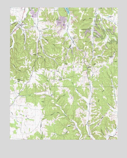
Sandy Hook, TN USGS Topographic Map
Click on map above to begin viewing in our Map Viewer.

This topographic map contains these locations and features:
Feature Name Type Latitude Longitude GNIS ID View Map
Anderson Creek CemeteryCemeteryN35.4167°W87.2031°1275714View Map
Anderson Creek School (historical)SchoolN35.4023°W87.1883°1316251View Map
Andy HollowValleyN35.3809°W87.1343°1275752View Map
Arrow LakeReservoirN35.4986°W87.1845°1275908View Map
Arrow Lake MineMineN35.4970°W87.1867°1323659View Map
Bethel ChurchChurchN35.4781°W87.2161°1305131View Map
Biggen HollowValleyN35.4540°W87.2168°1277448View Map
Blowing SpringSpringN35.4553°W87.2197°1277727View Map
Blowing Spring CemeteryCemeteryN35.4553°W87.2186°1305299View Map
Brushy BranchStreamN35.4059°W87.2458°1278694View Map
Bumpass-King CemeteryCemeteryN35.4792°W87.2250°1646151View Map
Cantrell HollowValleyN35.4783°W87.2154°1279622View Map
Chavers CemeteryCemeteryN35.4940°W87.2461°1646166View Map
Coffey CemeteryCemeteryN35.4687°W87.1572°1646170View Map
District 11 (historical)CivilN35.4584°W87.1667°1310220View Map
District 12 (historical)CivilN35.4834°W87.2333°1310221View Map
Dog branchStreamN35.4717°W87.1792°1647698View Map
Dog HollowValleyN35.4675°W87.1779°1282593View Map
Dry CreekStreamN35.4954°W87.2297°1282912View Map
Dry Creek School (historical)SchoolN35.4784°W87.2164°1323686View Map
Dyestone HollowValleyN35.3990°W87.1869°1283269View Map
Ebenezer CemeteryCemeteryN35.4851°W87.1517°1646202View Map
Ebenezer ChurchChurchN35.4845°W87.1520°1306413View Map
Elk Ridge CemeteryCemeteryN35.4484°W87.1314°1643988View Map
Elk Ridge SchoolSchoolN35.4470°W87.1325°1283641View Map
EnterprisePopulated PlaceN35.4717°W87.1795°1283822View Map
Enterprise School (historical)SchoolN35.4673°W87.1772°1323689View Map
Enterprise United Methodist ChurchChurchN35.4667°W87.1770°1646205View Map
Ettaton SchoolSchoolN35.4937°W87.1495°1283872View Map
Falls CreekStreamN35.4751°W87.2486°1284105View Map
Fanny BranchStreamN35.4162°W87.2020°1284123View Map
Flag Springs School (historical)SchoolN35.4084°W87.1589°1316270View Map
Flanigan HillSummitN35.4587°W87.1281°1284361View Map
Francis HollowValleyN35.4021°W87.1278°1284804View Map
Freedom ChurchChurchN35.4298°W87.2386°1284878View Map
Freedom School (historical)SchoolN35.4295°W87.2383°1303005View Map
Gilbreath-Morrow CemeteryCemeteryN35.4684°W87.1333°1646234View Map
Gilliam MineMineN35.4809°W87.1570°1323698View Map
Guthrie HollowValleyN35.4908°W87.1532°1306528View Map
Holt HollowValleyN35.4536°W87.1531°1288166View Map
Howell CemeteryCemeteryN35.4573°W87.1300°1646274View Map
Hydes GapGapN35.4354°W87.1600°1310377View Map
Johnson BranchStreamN35.4090°W87.1597°1289525View Map
Johnson HillSummitN35.4815°W87.2267°1289604View Map
JonestownPopulated PlaceN35.3948°W87.2128°1315306View Map
Kittrell MineMineN35.4820°W87.1881°1323712View Map
Lasley CemeteryCemeteryN35.4873°W87.2389°1646296View Map
Little Terrapin BranchStreamN35.4904°W87.1445°1291689View Map
Mack BranchStreamN35.3870°W87.1258°1292443View Map
McKissick LakeReservoirN35.4913°W87.1360°1293388View Map
Mount Olive Church (historical)ChurchN35.4070°W87.2497°1303034View Map
Mount Zion ChurchChurchN35.4401°W87.1956°1294879View Map
Murphey CemeteryCemeteryN35.4880°W87.1366°1646478View Map
Murphey CemeteryCemeteryN35.4780°W87.1565°2742536View Map
Murphy CemeteryCemeteryN35.4692°W87.1286°1646477View Map
New Hope CemeteryCemeteryN35.4481°W87.1286°1644020View Map
New Hope ChurchChurchN35.4487°W87.1286°1295526View Map
Nubbin RidgeRidgeN35.4059°W87.1456°1296005View Map
Orrs ChapelChurchN35.4784°W87.2342°1296496View Map
Painter PondLakeN35.4109°W87.2105°1296673View Map
Pickard HollowValleyN35.4870°W87.2407°1297382View Map
Powdermill BranchStreamN35.3867°W87.1731°1298389View Map
Powell CemeteryCemeteryN35.4340°W87.1886°1646506View Map
Saint John ChurchChurchN35.3926°W87.1445°1300443View Map
Saint John School (historical)SchoolN35.3931°W87.1447°1316312View Map
Sandy HookPopulated PlaceN35.4834°W87.2375°1307027View Map
Sandy Hook School (historical)SchoolN35.4842°W87.2403°1324890View Map
Schoolhouse HollowValleyN35.4109°W87.1965°1300892View Map
Scotts MillPopulated PlaceN35.4998°W87.1483°1307035View Map
ScreamerPopulated PlaceN35.4440°W87.1597°1315883View Map
Selph School (historical)SchoolN35.3812°W87.2306°1303053View Map
Sheepneck CemeteryCemeteryN35.4787°W87.2345°1646537View Map
Sheepneck HollowValleyN35.4817°W87.2369°1269971View Map
Smith HollowValleyN35.4700°W87.2147°1270682View Map
Spencer HillPopulated PlaceN35.4487°W87.1639°1314319View Map
Spencer Hill CemeteryCemeteryN35.4478°W87.1661°1646546View Map
Spencer Hill ChurchChurchN35.4492°W87.1633°1324901View Map
Stillhouse HollowValleyN35.3774°W87.1391°1271410View Map
Stone CemeteryCemeteryN35.4762°W87.2181°1646553View Map
Terrapin BranchStreamN35.4954°W87.1492°1272322View Map
Turnbo CemeteryCemeteryN35.4644°W87.1743°1646564View Map
Ward-Gilliam MineMineN35.4712°W87.1895°1324913View Map
Watts HillSummitN35.4465°W87.1864°1273947View Map
Watts Hill CemeteryCemeteryN35.4437°W87.1864°1646573View Map
Willis ChapelChurchN35.4809°W87.2375°1274743View Map
Wiltshire HollowValleyN35.4715°W87.2136°1274847View Map

Note: Coordinates in the location and feature list above are referenced to NAD83 datum.


Copyright (C) 2008-2025 Ryan Niemi / Sunset Dynamics ... All Rights Reserved