TopoQuest Logo
Do you find TopoQuest useful?
Help keep TopoQuest running and adding new maps/features by donating!
Bitcoin:  19c7KJd3qBynnjoSw5npx9KScwjBe4ifkT
Litecoin:  LXs6TkuXGGXo1vDsWCkWVdjQX94eUKd6ui
Home View Maps Find Maps Find Places Resources & Links


Mount Maurice, Montana Topographic Map

USGS Map Title: Mount Maurice, MT
USGS Map MRC: 45109A3
DRG (GeoTIFF) Download: o45109a3.tif


Neighboring USGS Topographic Map Quads:


  Bare Mountain, MT  
45109B4
 

  Red Lodge West, MT  
45109B3
 

  Red Lodge East, MT  
45109B2
 

  Black Pyramid Mountain, MT  
45109A4
 

  Mount Maurice, MT  
45109A3
 

  Tolman Flat, MT  
45109A2
 

  Deep Lake, WY  
44109H4
 

  North Bennett Creek, WY  
44109H3
 

  Clark, WY  
44109H2


Map MRC Location:

N46°
W110°
N46°
W109°
H8 H7 H6 H5 H4 H3 H2 H1
G8 G7 G6 G5 G4 G3 G2 G1
F8 F7 F6 F5 F4 F3 F2 F1
E8 E7 E6 E5 E4 E3 E2 E1
D8 D7 D6 D5 D4 D3 D2 D1
C8 C7 C6 C5 C4 C3 C2 C1
B8 B7 B6 B5 B4 B3 B2 B1
A8 A7 A6 A5 A4 A3 A2 A1
N45°
W110°
N45°
W109°

Mount Maurice, MT USGS 1:24K Topographic Map Preview:
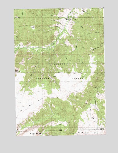
Mount Maurice, MT USGS Topographic Map
Click on map above to begin viewing in our Map Viewer.

This topographic map contains these locations and features:
Feature Name Type Latitude Longitude GNIS ID View Map
Camp MilesLocaleN45.0852°W109.3502°780860View Map
Corral CreekStreamN45.0869°W109.3279°781692View Map
Custer National Forest - Beartooth DivisionForestN45.0930°W109.3396°800085View Map
Custer National Forest TrailTrailN45.0399°W109.3329°794062View Map
Cyclone CreekStreamN45.1149°W109.2993°782015View Map
Hakel GulchValleyN45.1044°W109.3096°784456View Map
Haywood GulchValleyN45.1249°W109.2949°784679View Map
Line Creek Forest Service StationLocaleN45.0213°W109.2774°786178View Map
Line Creek PlateauPlainN45.0286°W109.3557°786179View Map
Maurice CreekStreamN45.1174°W109.2990°786935View Map
Maurice MountSummitN45.0997°W109.2579°786936View Map
Piney DellLocaleN45.1138°W109.2996°788910View Map
Ratine CampgroundLocaleN45.0899°W109.3238°789395View Map
Ratine CreekStreamN45.0883°W109.3240°789396View Map
Seeley CreekStreamN45.1038°W109.3052°790195View Map
Sheep CreekStreamN45.0872°W109.3685°790333View Map
Sheridan CampgroundLocaleN45.1013°W109.3029°790401View Map
Sheridan CreekStreamN45.0955°W109.3138°790402View Map
Sheridan PointCapeN45.0569°W109.3177°790406View Map
Snow CreekStreamN45.0861°W109.3715°790774View Map
Spring CreekStreamN45.0858°W109.3363°791232View Map
Tolman MountainSummitN45.0644°W109.3707°792247View Map
Wapiti MountainSummitN45.1069°W109.3477°792803View Map
Woods GulchValleyN45.1083°W109.3074°793519View Map
Yellowstone-Bighorn Research CampLocaleN45.1219°W109.2729°793610View Map

Note: Coordinates in the location and feature list above are referenced to NAD83 datum.


Copyright (C) 2008-2025 Ryan Niemi / Sunset Dynamics ... All Rights Reserved