TopoQuest Logo
Do you find TopoQuest useful?
Help keep TopoQuest running and adding new maps/features by donating!
Bitcoin:  19c7KJd3qBynnjoSw5npx9KScwjBe4ifkT
Litecoin:  LXs6TkuXGGXo1vDsWCkWVdjQX94eUKd6ui
Home View Maps Find Maps Find Places Resources & Links


Mount Mitchell, Washington Topographic Map

USGS Map Title: Mount Mitchell, WA
USGS Map MRC: 46122A2
DRG (GeoTIFF) Download: o46122a2.tif


Neighboring USGS Topographic Map Quads:


  Goat Mountain, WA  
46122B3
 

  Mount Saint Helens, WA  
46122B2
 

  Smith Creek Butte, WA  
46122B1
 

  Cougar, WA  
46122A3
 

  Mount Mitchell, WA  
46122A2
 

  Cedar Flats, WA  
46122A1
 

  Yale Dam, WA  
45122H3
 

  Siouxon Peak, WA  
45122H2
 

  Bare Mountain, WA  
45122H1


Map MRC Location:

N47°
W123°
N47°
W122°
H8 H7 H6 H5 H4 H3 H2 H1
G8 G7 G6 G5 G4 G3 G2 G1
F8 F7 F6 F5 F4 F3 F2 F1
E8 E7 E6 E5 E4 E3 E2 E1
D8 D7 D6 D5 D4 D3 D2 D1
C8 C7 C6 C5 C4 C3 C2 C1
B8 B7 B6 B5 B4 B3 B2 B1
A8 A7 A6 A5 A4 A3 A2 A1
N46°
W123°
N46°
W122°

Mount Mitchell, WA USGS 1:24K Topographic Map Preview:
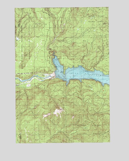
Mount Mitchell, WA USGS Topographic Map
Click on map above to begin viewing in our Map Viewer.

This topographic map contains these locations and features:
Feature Name Type Latitude Longitude GNIS ID View Map
Ape Cave EntranceLocaleN46.1237°W122.2170°1529173View Map
Ape Cave SkylightLocaleN46.1193°W122.2182°1529174View Map
Cougar CreekStreamN46.0982°W122.2484°1531428View Map
Devils BackboneRidgeN46.0690°W122.1848°1518694View Map
Diamond CreekStreamN46.0715°W122.1676°1518745View Map
Grass LakeLakeN46.0946°W122.2443°1520247View Map
Green MountainSummitN46.0818°W122.2348°1528833View Map
Lava Cast Picnic AreaLocaleN46.0996°W122.2132°1528832View Map
Marble CreekStreamN46.0671°W122.1459°1522701View Map
Marble MountainSummitN46.1084°W122.1295°1522710View Map
Mount MitchellSummitN46.0312°W122.1929°1523296View Map
Mount Mitchell LookoutLocaleN46.0309°W122.1931°1530173View Map
Ole CreekStreamN46.0548°W122.2368°1524023View Map
Rain CreekStreamN46.0509°W122.2390°1524811View Map
Swift CreekStreamN46.0837°W122.1998°1526860View Map
Swift DamDamN46.0632°W122.1979°1532121View Map
Swift Dam OverlookLocaleN46.0679°W122.1984°1528985View Map
Swift Number Two ForebayReservoirN46.0588°W122.2318°1532267View Map
Swift ViewpointLocaleN46.0718°W122.2004°1529172View Map
West Fork Swift CreekStreamN46.0973°W122.1965°1527977View Map

Note: Coordinates in the location and feature list above are referenced to NAD83 datum.


Copyright (C) 2008-2024 Ryan Niemi / Sunset Dynamics ... All Rights Reserved