TopoQuest Logo
Do you find TopoQuest useful?
Help keep TopoQuest running and adding new maps/features by donating!
Bitcoin:  19c7KJd3qBynnjoSw5npx9KScwjBe4ifkT
Litecoin:  LXs6TkuXGGXo1vDsWCkWVdjQX94eUKd6ui
Home View Maps Find Maps Find Places Resources & Links


Beeville West, Texas Topographic Map

USGS Map Title: Beeville West, TX
USGS Map MRC: 28097D7
DRG (GeoTIFF) Download: o28097d7.tif


Neighboring USGS Topographic Map Quads:


  Mineral, TX  
28097E8
 

  Tuleta, TX  
28097E7
 

  Lazy F Ranch, TX  
28097E6
 

  Cadiz, TX  
28097D8
 

  Beeville West, TX  
28097D7
 

  Beeville East, TX  
28097D6
 

  Mulos Hills, TX  
28097C8
 

  Clareville, TX  
28097C7
 

  Skidmore, TX  
28097C6


Map MRC Location:

N29°
W98°
N29°
W97°
H8 H7 H6 H5 H4 H3 H2 H1
G8 G7 G6 G5 G4 G3 G2 G1
F8 F7 F6 F5 F4 F3 F2 F1
E8 E7 E6 E5 E4 E3 E2 E1
D8 D7 D6 D5 D4 D3 D2 D1
C8 C7 C6 C5 C4 C3 C2 C1
B8 B7 B6 B5 B4 B3 B2 B1
A8 A7 A6 A5 A4 A3 A2 A1
N28°
W98°
N28°
W97°

Beeville West, TX USGS 1:24K Topographic Map Preview:
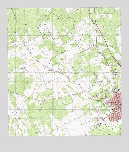
Beeville West, TX USGS Topographic Map
Click on map above to begin viewing in our Map Viewer.

This topographic map contains these locations and features:
Feature Name Type Latitude Longitude GNIS ID View Map
A C Jones High SchoolSchoolN28.4192°W97.7539°1338856View Map
Adams Saint Church of ChristChurchN28.4172°W97.7533°2016507View Map
Alta Vista ParkParkN28.3919°W97.7547°1329441View Map
Angel Care Ambulance ServiceBuildingN28.3974°W97.7577°2656038View Map
Beeville Art MuseumBuildingN28.4133°W97.7508°2014310View Map
Beeville City HallBuildingN28.4049°W97.7505°2753357View Map
Beeville Country ClubLocaleN28.4461°W97.7697°1384292View Map
Beeville Police Community Training CenterBuildingN28.3984°W97.7528°2335002View Map
Beeville Police DepartmentBuildingN28.4049°W97.7506°2335160View Map
Beeville Volunteer Fire DepartmentBuildingN28.4050°W97.7502°2334260View Map
Bethel Pentecostal ChurchChurchN28.3933°W97.7553°2016511View Map
Blue Berry HillPopulated PlaceN28.3889°W97.7822°1852687View Map
Blue Berry Hill Census Designated PlaceCensusN28.3855°W97.7920°2407865View Map
Blue Berry Hill ColoniaPopulated PlaceN28.3892°W97.7783°2010296View Map
Brown Ranch Airport (historical)AirportN28.4419°W97.8044°1386234View Map
Cementerio EvangelicoCemeteryN28.4103°W97.7725°1332506View Map
Coastal Bend CollegeSchoolN28.4358°W97.7573°2434570View Map
First Baptist Church SchoolSchoolN28.4068°W97.7504°2434440View Map
First Presbyterian ChurchChurchN28.4086°W97.7533°2016513View Map
Flournoy ParkParkN28.4128°W97.7547°1335978View Map
Friendship ChurchChurchN28.4642°W97.8561°1336224View Map
Hall SchoolSchoolN28.4097°W97.7650°1337255View Map
Jackson SchoolSchoolN28.4022°W97.7539°1338603View Map
Jones Chapel Methodist ChurchChurchN28.3986°W97.7558°2016510View Map
Kobler ParkParkN28.4089°W97.7633°1339205View Map
KYTX-FM (Beeville)TowerN28.4453°W97.7642°1385775View Map
Moreno Junior High SchoolSchoolN28.3992°W97.7609°2002965View Map
Northwest Area ParkParkN28.4017°W97.7681°1342872View Map
Old Airport Road ColoniaPopulated PlaceN28.4253°W97.7683°2010299View Map
OrangedalePopulated PlaceN28.4394°W97.8261°1343305View Map
Our Lady of Victory CemeteryCemeteryN28.4100°W97.7719°1343349View Map
Our Lady of Victory SchoolSchoolN28.4057°W97.7539°1343351View Map
Primera Iglesia Bautista ChurchChurchN28.3981°W97.7517°2016506View Map
R A Hall Elementary SchoolSchoolN28.4094°W97.7649°2002963View Map
Reyes ParkParkN28.3878°W97.7578°2029483View Map
Salazar Heights ColoniaPopulated PlaceN28.3853°W97.7903°2010302View Map
Ten Acre ParkParkN28.3892°W97.7553°1348356View Map
Veterans Memorial ParkParkN28.3986°W97.7697°2030015View Map

Note: Coordinates in the location and feature list above are referenced to NAD83 datum.


Copyright (C) 2008-2024 Ryan Niemi / Sunset Dynamics ... All Rights Reserved