TopoQuest Logo
Do you find TopoQuest useful?
Help keep TopoQuest running and adding new maps/features by donating!
Bitcoin:  19c7KJd3qBynnjoSw5npx9KScwjBe4ifkT
Litecoin:  LXs6TkuXGGXo1vDsWCkWVdjQX94eUKd6ui
Home View Maps Find Maps Find Places Resources & Links


Mountain View, Hawaii Topographic Map

USGS Map Title: Mountain View, HI
USGS Map MRC: 19155E1
DRG (GeoTIFF) Download: o19155e1.tif


Neighboring USGS Topographic Map Quads:


  Piihonua, HI  
19155F2
 

  Hilo, HI  
19155F1
 

  Keaau Ranch, HI  
19154F8
 

  Puumakaala, HI  
19155E2
 

  Mountain View, HI  
19155E1
 

  Pahoa North, HI  
19154E8
 

  Volcano, HI  
19155D2
 

  Kalalua, HI  
19155D1
 

  Pahoa South, HI  
19154D8


Map MRC Location:

N20°
W156°
N20°
W155°
H8 H7 H6 H5 H4 H3 H2 H1
G8 G7 G6 G5 G4 G3 G2 G1
F8 F7 F6 F5 F4 F3 F2 F1
E8 E7 E6 E5 E4 E3 E2 E1
D8 D7 D6 D5 D4 D3 D2 D1
C8 C7 C6 C5 C4 C3 C2 C1
B8 B7 B6 B5 B4 B3 B2 B1
A8 A7 A6 A5 A4 A3 A2 A1
N19°
W156°
N19°
W155°

Mountain View, HI USGS 1:24K Topographic Map Preview:
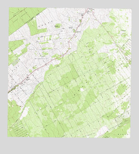
Mountain View, HI USGS Topographic Map
Click on map above to begin viewing in our Map Viewer.

This topographic map contains these locations and features:
Feature Name Type Latitude Longitude GNIS ID View Map
Elevenmile HomesteadPopulated PlaceN19.6037°W155.0715°358800View Map
Fern AcresPopulated PlaceN19.5122°W155.0803°1852577View Map
Fern Acres Census Designated PlaceCensusN19.5082°W155.0785°2414017View Map
Fern Acres Volunteer Fire Station 5DBuildingN19.5351°W155.0899°2638033View Map
Ferndale (historical)Populated PlaceN19.5743°W155.0754°1905314View Map
Fourteen and Onehalf Mile Store (historical)LocaleN19.5706°W155.0869°1905317View Map
Hawaii County Fire Department Station 5 KeaauBuildingN19.6211°W155.0401°2637966View Map
Hawaiian AcresPopulated PlaceN19.5381°W155.0522°1852579View Map
Hawaiian Acres Census Designated PlaceCensusN19.5325°W155.0497°2414035View Map
Hawaiian Acres Volunteer Fire Station 05BBuildingN19.5579°W155.0509°2638025View Map
??la?a Dispensary (historical)HospitalN19.6122°W155.0500°362768View Map
??la?a Reservation HomesteadsCivilN19.5806°W155.0917°358395View Map
Iwasaki CampLocaleN19.6061°W155.0636°359513View Map
Keaau Census Designated PlaceCensusN19.6155°W155.0372°2414071View Map
Keaau Post OfficePost OfficeN19.6217°W155.0402°2773457View Map
Keaau-Mountain View DivisionCivilN19.5569°W155.0958°1935652View Map
Kea?auCivilN19.5594°W155.0486°360891View Map
Kea?auPopulated PlaceN19.6227°W155.0374°360892View Map
Kea?au CampLocaleN19.6222°W155.0456°360895View Map
Kea?au Elementary SchoolSchoolN19.6244°W155.0408°1905431View Map
Kea?au Shopping Plaza Shopping CenterLocaleN19.6244°W155.0419°1905432View Map
KukuiPopulated PlaceN19.5745°W155.0886°361522View Map
KurtistownPopulated PlaceN19.6021°W155.0484°361629View Map
Kurtistown Census Designated PlaceCensusN19.5833°W155.0721°2414080View Map
Kurtistown Jodo CemeteryCemeteryN19.6005°W155.0567°1956657View Map
Kurtistown Jodo MissionChurchN19.6033°W155.0583°1956658View Map
Kurtistown Post OfficePost OfficeN19.5934°W155.0573°1956659View Map
Kurtistown SchoolSchoolN19.5878°W155.0633°361630View Map
Mountain ViewPopulated PlaceN19.5527°W155.1043°362495View Map
Mountain View AirstripAirportN19.5468°W155.1087°365443View Map
Mountain View Elementary SchoolSchoolN19.5575°W155.1056°1905525View Map
Mountain View Post OfficePost OfficeN19.5493°W155.1091°2773466View Map
Nine and Onehalf Mile CampLocaleN19.6183°W155.0514°362648View Map
Ninemile CampLocaleN19.6225°W155.0433°362649View Map
Ohia (historical)Populated PlaceN19.5846°W155.0765°1905533View Map
Orchidlands EstatesPopulated PlaceN19.5608°W155.0153°1852582View Map
Orchidlands Estates Census Designated PlaceCensusN19.5570°W155.0142°2414112View Map
Pulu (historical)Populated PlaceN19.5595°W155.1005°1905561View Map
Puna DistrictCivilN19.5000°W155.0000°1853107View Map
Twelvemile School (historical)SchoolN19.5875°W155.0608°1905590View Map
Waikahekahe IkiCivilN19.5053°W155.0247°364644View Map
Waip?hoehoePopulated PlaceN19.6003°W155.0076°365198View Map

Note: Coordinates in the location and feature list above are referenced to NAD83 datum.


Copyright (C) 2008-2025 Ryan Niemi / Sunset Dynamics ... All Rights Reserved