TopoQuest Logo
Do you find TopoQuest useful?
Help keep TopoQuest running and adding new maps/features by donating!
Bitcoin:  19c7KJd3qBynnjoSw5npx9KScwjBe4ifkT
Litecoin:  LXs6TkuXGGXo1vDsWCkWVdjQX94eUKd6ui
Home View Maps Find Maps Find Places Resources & Links


Mountain View Lake, Idaho Topographic Map

USGS Map Title: Mountain View Lake, ID
USGS Map MRC: 42116A2
DRG (GeoTIFF) Download: o42116a2.tif


Neighboring USGS Topographic Map Quads:


  Ross Lake, ID  
42116B3
 

  Flying H Ranch, ID  
42116B2
 

  Riddle, ID  
42116B1
 

  Juniper Basin SE, ID  
42116A3
 

  Mountain View Lake, ID  
42116A2
 

  Three Forks, ID  
42116A1
 

  Groundhog Reservoir, NV  
41116H3
 

  The Point, NV  
41116H2
 

  Owyhee, NV  
41116H1


Map MRC Location:

N43°
W117°
N43°
W116°
H8 H7 H6 H5 H4 H3 H2 H1
G8 G7 G6 G5 G4 G3 G2 G1
F8 F7 F6 F5 F4 F3 F2 F1
E8 E7 E6 E5 E4 E3 E2 E1
D8 D7 D6 D5 D4 D3 D2 D1
C8 C7 C6 C5 C4 C3 C2 C1
B8 B7 B6 B5 B4 B3 B2 B1
A8 A7 A6 A5 A4 A3 A2 A1
N42°
W117°
N42°
W116°

Mountain View Lake, ID USGS 1:24K Topographic Map Preview:
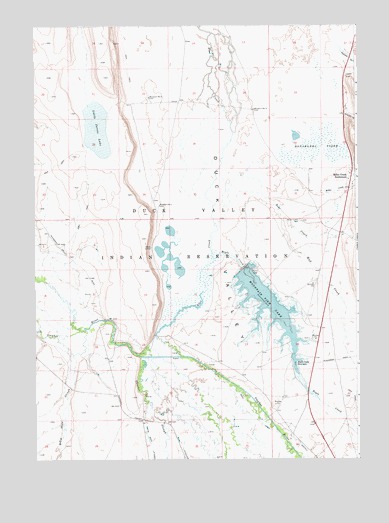
Mountain View Lake, ID USGS Topographic Map
Click on map above to begin viewing in our Map Viewer.

This topographic map contains these locations and features:
Feature Name Type Latitude Longitude GNIS ID View Map
Bell CreekStreamN42.0671°W116.1801°371436View Map
Billy Shaw SloughStreamN42.0301°W116.2356°371551View Map
Blue CreekStreamN42.0299°W116.2104°371611View Map
Boyle CreekStreamN42.0576°W116.1810°371674View Map
Boyle Creek ReservoirReservoirN42.0276°W116.1496°371675View Map
Damon Trail CreekStreamN42.1043°W116.1307°372309View Map
Donabahba YogeeSwampN42.0895°W116.1409°372440View Map
Duck Valley DivisionCivilN42.0780°W116.1858°1936831View Map
Little Jarvis LakeLakeN42.0955°W116.2273°373647View Map
Main CanalCanalN42.0110°W116.1643°372103View Map
Miller CreekStreamN42.0771°W116.1395°373951View Map
Miller Creek CemeteryCemeteryN42.0687°W116.1478°373952View Map
Miller Creek SettlementPopulated PlaceN42.0816°W116.1282°396897View Map
Mountain View DamDamN42.0549°W116.1701°398880View Map
Mountain View LakeReservoirN42.0449°W116.1606°397938View Map
Mud CreekStreamN42.0705°W116.1554°374051View Map
Stone CorralLocaleN42.0610°W116.2054°375291View Map
Thacker LateralCanalN42.0030°W116.1934°375451View Map
Thacker SloughStreamN42.0295°W116.2092°375452View Map
Windmill Number 1LocaleN42.0732°W116.2020°400315View Map
Windmill Number 2LocaleN42.1046°W116.2062°400316View Map
Windmill Number 3LocaleN42.1007°W116.1657°400317View Map

Note: Coordinates in the location and feature list above are referenced to NAD83 datum.


Copyright (C) 2008-2025 Ryan Niemi / Sunset Dynamics ... All Rights Reserved