TopoQuest Logo
Do you find TopoQuest useful?
Help keep TopoQuest running and adding new maps/features by donating!
Bitcoin:  19c7KJd3qBynnjoSw5npx9KScwjBe4ifkT
Litecoin:  LXs6TkuXGGXo1vDsWCkWVdjQX94eUKd6ui
Home View Maps Find Maps Find Places Resources & Links


Mountainburg SW, Arkansas Topographic Map

USGS Map Title: Mountainburg SW, AR
USGS Map MRC: 35094E2
DRG (GeoTIFF) Download: o35094e2.tif


Neighboring USGS Topographic Map Quads:


  Rudy NE, AR  
35094F3
 

  Mountainburg, AR  
35094F2
 

  Fern, AR  
35094F1
 

  Rudy, AR  
35094E3
 

  Mountainburg SW, AR  
35094E2
 

  Mountainburg SE, AR  
35094E1
 

  Van Buren, AR  
35094D3
 

  Alma, AR  
35094D2
 

  Mulberry, AR  
35094D1


Map MRC Location:

N36°
W95°
N36°
W94°
H8 H7 H6 H5 H4 H3 H2 H1
G8 G7 G6 G5 G4 G3 G2 G1
F8 F7 F6 F5 F4 F3 F2 F1
E8 E7 E6 E5 E4 E3 E2 E1
D8 D7 D6 D5 D4 D3 D2 D1
C8 C7 C6 C5 C4 C3 C2 C1
B8 B7 B6 B5 B4 B3 B2 B1
A8 A7 A6 A5 A4 A3 A2 A1
N35°
W95°
N35°
W94°

Mountainburg SW, AR USGS 1:24K Topographic Map Preview:
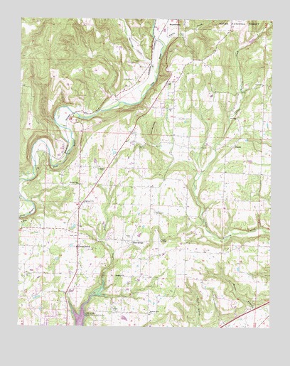
Mountainburg SW, AR USGS Topographic Map
Click on map above to begin viewing in our Map Viewer.

This topographic map contains these locations and features:
Feature Name Type Latitude Longitude GNIS ID View Map
Belmont (historical)Populated PlaceN35.5598°W94.1785°66230View Map
Bolton CemeteryCemeteryN35.5465°W94.1830°70760View Map
Bond Special Dean Springs and Rudy District 1 Dean Springs Fire StationBuildingN35.5360°W94.1804°2116173View Map
Bonita HollowValleyN35.5454°W94.2474°74269View Map
CainPopulated PlaceN35.5998°W94.1777°70952View Map
Cain CemeteryCemeteryN35.5845°W94.1677°70953View Map
Cain ChurchChurchN35.5884°W94.1749°70954View Map
Church of ChristChurchN35.5351°W94.1799°65681View Map
Conley CemeteryCemeteryN35.6076°W94.1913°71211View Map
Crawford CountyCivilN35.5891°W94.2429°69161View Map
Dean SpringsPopulated PlaceN35.5356°W94.1952°71350View Map
Deans CemeteryCemeteryN35.5367°W94.1941°71353View Map
Deans MarketPopulated PlaceN35.5323°W94.2208°76768View Map
Fine SpringsSpringN35.5398°W94.2235°66232View Map
Fine Springs Baptist ChurchChurchN35.5348°W94.2210°65697View Map
Freedom ChurchChurchN35.5209°W94.1980°71680View Map
GraphicPopulated PlaceN35.5734°W94.1435°71808View Map
Gregory CemeteryCemeteryN35.5065°W94.2035°71841View Map
Gregory ChapelChurchN35.5640°W94.2108°71842View Map
Hammond LakeReservoirN35.6151°W94.1385°80994View Map
Hammond Lake DamDamN35.6151°W94.1385°80993View Map
Hatfield CemeteryCemeteryN35.6004°W94.1946°71934View Map
Highway 71 ChurchChurchN35.5506°W94.2183°72016View Map
Hurricane CreekStreamN35.6004°W94.1830°72123View Map
Lake AlmaReservoirN35.5020°W94.2196°70433View Map
Lancaster (historical)Populated PlaceN35.5704°W94.2274°81945View Map
Love CemeteryCemeteryN35.5315°W94.2169°72497View Map
Morris LakeReservoirN35.5251°W94.2302°80098View Map
Morris Lake DamDamN35.5251°W94.2302°80097View Map
Mountain Grove ChurchChurchN35.5059°W94.1849°72785View Map
Mountain View ChurchChurchN35.5579°W94.2210°72795View Map
New Hope ChurchChurchN35.5845°W94.1424°72856View Map
Newberry ChurchChurchN35.5212°W94.2469°72861View Map
Peters CemeteryCemeteryN35.5731°W94.1916°73052View Map
Pigeon CreekStreamN35.6106°W94.1802°73070View Map
Revis Hill Assembly of God ChurchChurchN35.5987°W94.1296°78168View Map
Rural District 3 GraphicBuildingN35.5735°W94.1439°2117059View Map
Town of RudyCivilN35.5285°W94.2411°2407256View Map
Township of Dean SpringsCivilN35.5427°W94.1839°2406946View Map
Township of Lafayette (historical)CivilN35.5404°W94.1835°68728View Map
Township of LancasterCivilN35.5770°W94.2342°68729View Map
Township of Mountain (historical)CivilN35.6181°W94.1960°68732View Map
Township of MountainburgCivilN35.6211°W94.1888°2406961View Map
Township of RudyCivilN35.5291°W94.2479°68736View Map
Winn MountainSummitN35.5798°W94.1841°78789View Map
Wynn GraveyardCemeteryN35.5420°W94.2263°65759View Map

Note: Coordinates in the location and feature list above are referenced to NAD83 datum.


Copyright (C) 2008-2024 Ryan Niemi / Sunset Dynamics ... All Rights Reserved