TopoQuest Logo
Do you find TopoQuest useful?
Help keep TopoQuest running and adding new maps/features by donating!
Bitcoin:  19c7KJd3qBynnjoSw5npx9KScwjBe4ifkT
Litecoin:  LXs6TkuXGGXo1vDsWCkWVdjQX94eUKd6ui
Home View Maps Find Maps Find Places Resources & Links


Mountainburg, Arkansas Topographic Map

USGS Map Title: Mountainburg, AR
USGS Map MRC: 35094F2
DRG (GeoTIFF) Download: o35094f2.tif


Neighboring USGS Topographic Map Quads:


  Strickler, AR  
35094G3
 

  Winslow, AR  
35094G2
 

  Brentwood, AR  
35094G1
 

  Rudy NE, AR  
35094F3
 

  Mountainburg, AR  
35094F2
 

  Fern, AR  
35094F1
 

  Rudy, AR  
35094E3
 

  Mountainburg SW, AR  
35094E2
 

  Mountainburg SE, AR  
35094E1


Map MRC Location:

N36°
W95°
N36°
W94°
H8 H7 H6 H5 H4 H3 H2 H1
G8 G7 G6 G5 G4 G3 G2 G1
F8 F7 F6 F5 F4 F3 F2 F1
E8 E7 E6 E5 E4 E3 E2 E1
D8 D7 D6 D5 D4 D3 D2 D1
C8 C7 C6 C5 C4 C3 C2 C1
B8 B7 B6 B5 B4 B3 B2 B1
A8 A7 A6 A5 A4 A3 A2 A1
N35°
W95°
N35°
W94°

Mountainburg, AR USGS 1:24K Topographic Map Preview:
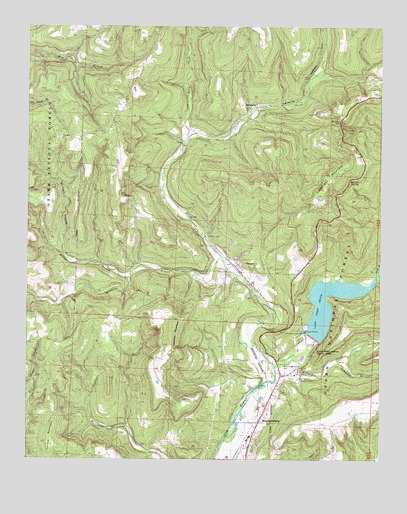
Mountainburg, AR USGS Topographic Map
Click on map above to begin viewing in our Map Viewer.

This topographic map contains these locations and features:
Feature Name Type Latitude Longitude GNIS ID View Map
Armada (historical)Populated PlaceN35.7167°W94.1955°65668View Map
Artist PointPopulated PlaceN35.7198°W94.1374°70468View Map
Basham Memorial CemeteryCemeteryN35.6520°W94.1594°70523View Map
Campbell BranchStreamN35.6540°W94.1402°70974View Map
Cartwright MountainSummitN35.7073°W94.1416°71024View Map
ChesterPopulated PlaceN35.6809°W94.1752°71128View Map
Chester CemeteryCemeteryN35.6895°W94.1866°71129View Map
Chester Post OfficePost OfficeN35.6792°W94.1745°2781869View Map
City of MountainburgCivilN35.6361°W94.1680°2404334View Map
Clear CreekStreamN35.6529°W94.1627°81372View Map
Fort Smith Filtration PlantLocaleN35.6487°W94.1535°82432View Map
Freedom ChurchChurchN35.7179°W94.2383°71681View Map
Hillcrest CemeteryCemeteryN35.6342°W94.1477°72023View Map
KPOM-TV (Fort Smith)TowerN35.7104°W94.1377°85257View Map
Lake Fort SmithReservoirN35.6434°W94.1335°80018View Map
Lake Fort Smith DamDamN35.6434°W94.1335°80017View Map
Lake Fort Smith State ParkParkN35.6579°W94.1496°72279View Map
Lake Shepherd SpringsReservoirN35.6768°W94.1401°75124View Map
Locust MountainSummitN35.6345°W94.2402°72438View Map
Maddux SpringSpringN35.7062°W94.1334°72535View Map
Maddux SpringPopulated PlaceN35.7084°W94.1316°65724View Map
McCaslin BranchStreamN35.6834°W94.1813°72582View Map
Meadow MountainSummitN35.6637°W94.1983°72621View Map
MountainburgPopulated PlaceN35.6356°W94.1674°77771View Map
Mountainburg Elementary SchoolSchoolN35.6316°W94.1715°65727View Map
Mountainburg Fire StationBuildingN35.6341°W94.1695°2116836View Map
Mountainburg High SchoolSchoolN35.6305°W94.1718°65728View Map
Mountainburg Middle SchoolSchoolN35.6307°W94.1718°2039097View Map
Mountainburg Police DepartmentBuildingN35.6337°W94.1690°2118938View Map
Mountainburg ShelterLocaleN35.6426°W94.1621°74293View Map
Norman HollowValleyN35.6843°W94.2369°72878View Map
Riley CreekStreamN35.7173°W94.1938°73300View Map
Rural District 3 ChesterBuildingN35.6793°W94.1794°2117058View Map
SchabergPopulated PlaceN35.7273°W94.1696°78302View Map
Schaberg CemeteryCemeteryN35.7176°W94.1794°73489View Map
Town of ChesterCivilN35.6776°W94.1778°2406263View Map
Township of ChesterCivilN35.6791°W94.1824°68723View Map
Township of PorterCivilN35.7310°W94.1583°68734View Map
Warloop CreekStreamN35.6506°W94.1619°74005View Map
Wilson BranchStreamN35.6773°W94.2141°74171View Map

Note: Coordinates in the location and feature list above are referenced to NAD83 datum.


Copyright (C) 2008-2025 Ryan Niemi / Sunset Dynamics ... All Rights Reserved