TopoQuest Logo
Do you find TopoQuest useful?
Help keep TopoQuest running and adding new maps/features by donating!
Bitcoin:  19c7KJd3qBynnjoSw5npx9KScwjBe4ifkT
Litecoin:  LXs6TkuXGGXo1vDsWCkWVdjQX94eUKd6ui
Home View Maps Find Maps Find Places Resources & Links


Airey, Mississippi Topographic Map

USGS Map Title: Airey, MS
USGS Map MRC: 30089F1
DRG (GeoTIFF) Download: o30089f1.tif


Neighboring USGS Topographic Map Quads:


  Wiggins, MS  
30089G2
 

  Whites Crossing, MS  
30089G1
 

  Ramsey Springs, MS  
30088G8
 

  McHenry, MS  
30089F2
 

  Airey, MS  
30089F1
 

  Beatrice, MS  
30088F8
 

  Wortham, MS  
30089E2
 

  Success, MS  
30089E1
 

  White Plains, MS  
30088E8


Map MRC Location:

N31°
W90°
N31°
W89°
H8 H7 H6 H5 H4 H3 H2 H1
G8 G7 G6 G5 G4 G3 G2 G1
F8 F7 F6 F5 F4 F3 F2 F1
E8 E7 E6 E5 E4 E3 E2 E1
D8 D7 D6 D5 D4 D3 D2 D1
C8 C7 C6 C5 C4 C3 C2 C1
B8 B7 B6 B5 B4 B3 B2 B1
A8 A7 A6 A5 A4 A3 A2 A1
N30°
W90°
N30°
W89°

Airey, MS USGS 1:24K Topographic Map Preview:
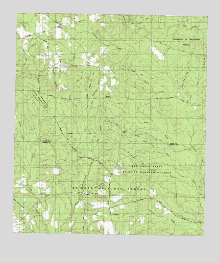
Airey, MS USGS Topographic Map
Click on map above to begin viewing in our Map Viewer.

This topographic map contains these locations and features:
Feature Name Type Latitude Longitude GNIS ID View Map
AireyPopulated PlaceN30.6485°W89.0773°692379View Map
Airey Lake Recreation AreaParkN30.6905°W89.0587°711496View Map
Airey Lookout TowerTowerN30.6894°W89.0639°711192View Map
Airey Work CenterLocaleN30.6894°W89.0648°705627View Map
Beaver Dam CreekStreamN30.6782°W89.1184°692510View Map
Beetree BranchStreamN30.7035°W89.0250°692528View Map
Big Foot TrailTrailN30.6669°W89.0334°705403View Map
Bigfoot Trail Camp Recreation AreaParkN30.6807°W89.0392°711497View Map
Bigfork Trail Riders CampgroundLocaleN30.6799°W89.0389°705626View Map
Boggy BranchStreamN30.6749°W89.0106°692659View Map
Bridge BranchStreamN30.6535°W89.0048°692702View Map
Broadus CemeteryCemeteryN30.6474°W89.1045°692710View Map
Broadus Lake DamDamN30.6369°W89.0067°695299View Map
Caney BranchStreamN30.6991°W89.1039°692832View Map
Copeland SpringSpringN30.6838°W89.0542°704554View Map
East Rattlesnake BranchStreamN30.6882°W89.0803°694515View Map
Edwards Lake DamDamN30.6535°W89.1167°695301View Map
Experiment Forest HeadquartersLocaleN30.6266°W89.0550°705628View Map
Harrison Experimental ForestAreaN30.6305°W89.0456°705643View Map
Lott CemeteryCemeteryN30.6641°W89.0570°705420View Map
McHenry BranchStreamN30.6777°W89.1184°693921View Map
McHenry Volunteer Fire Department Sunflower SubstationBuildingN30.7428°W89.0993°2667830View Map
Poplar Head ChurchChurchN30.6363°W89.0592°694457View Map
Pow Camp Recreation AreaParkN30.6391°W89.0056°711183View Map
Ship BranchStreamN30.6674°W89.0728°694770View Map
Spike Buck CreekStreamN30.6630°W89.0070°694854View Map
Sunflower Landmark Missionary Baptist ChurchChurchN30.7423°W89.0956°694907View Map
Supervisor District 4CivilN30.7322°W89.0274°712078View Map
Tuxachanie TrailTrailN30.6752°W89.0084°705432View Map
Tuxachena (historical)LocaleN30.7024°W89.0664°705904View Map
Tuxechena ChurchChurchN30.7030°W89.0662°705629View Map
West Rattlesnake BranchStreamN30.6877°W89.0806°695135View Map
WLOX-TV (Biloxi)TowerN30.7238°W89.0914°695256View Map
Wolf BranchStreamN30.6941°W89.0148°695200View Map

Note: Coordinates in the location and feature list above are referenced to NAD83 datum.


Copyright (C) 2008-2025 Ryan Niemi / Sunset Dynamics ... All Rights Reserved