TopoQuest Logo
Do you find TopoQuest useful?
Help keep TopoQuest running and adding new maps/features by donating!
Bitcoin:  19c7KJd3qBynnjoSw5npx9KScwjBe4ifkT
Litecoin:  LXs6TkuXGGXo1vDsWCkWVdjQX94eUKd6ui
Home View Maps Find Maps Find Places Resources & Links


Belews Lake, North Carolina Topographic Map

USGS Map Title: Belews Lake, NC
USGS Map MRC: 36080C1
DRG (GeoTIFF) Download: o36080c1.tif


Neighboring USGS Topographic Map Quads:


  Danbury, NC  
36080D2
 

  Ayersville, NC  
36080D1
 

  Mayodan, NC  
36079D8
 

  Walnut Cove, NC  
36080C2
 

  Belews Lake, NC  
36080C1
 

  Ellisboro, NC  
36079C8
 

  Walkertown, NC  
36080B2
 

  Belews Creek, NC  
36080B1
 

  Summerfield, NC  
36079B8


Map MRC Location:

N37°
W81°
N37°
W80°
H8 H7 H6 H5 H4 H3 H2 H1
G8 G7 G6 G5 G4 G3 G2 G1
F8 F7 F6 F5 F4 F3 F2 F1
E8 E7 E6 E5 E4 E3 E2 E1
D8 D7 D6 D5 D4 D3 D2 D1
C8 C7 C6 C5 C4 C3 C2 C1
B8 B7 B6 B5 B4 B3 B2 B1
A8 A7 A6 A5 A4 A3 A2 A1
N36°
W81°
N36°
W80°

Belews Lake, NC USGS 1:24K Topographic Map Preview:
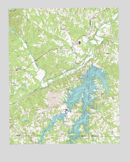
Belews Lake, NC USGS Topographic Map
Click on map above to begin viewing in our Map Viewer.

This topographic map contains these locations and features:
Feature Name Type Latitude Longitude GNIS ID View Map
Anderson HouseLocaleN36.3379°W80.0500°1008220View Map
Belews CreekStreamN36.3335°W80.0295°980925View Map
Belews Creek DamDamN36.3241°W80.0297°1000422View Map
Belews LakeReservoirN36.2837°W80.0430°980926View Map
Boy Scout PondReservoirN36.2727°W80.1054°1000448View Map
Boy Scout Pond DamDamN36.2718°W80.1064°1000447View Map
Bull RunStreamN36.2957°W80.1203°982213View Map
Camp VaughnLocaleN36.2715°W80.1073°982560View Map
Ceramic (historical)Populated PlaceN36.3068°W80.0856°1023600View Map
Chisman (historical)Populated PlaceN36.3149°W80.0637°1952729View Map
Dry Hollow ChurchChurchN36.2785°W80.0873°984365View Map
East Walnut Cove Community ParkParkN36.2879°W80.1156°1008221View Map
Eden CemeteryCemeteryN36.3321°W80.0114°1953019View Map
Eden United Methodist ChurchChurchN36.3329°W80.0112°984626View Map
Eurins CreekStreamN36.3318°W80.0306°984850View Map
Fellowship ChurchChurchN36.2954°W80.0203°985046View Map
Forest ChapelChurchN36.2715°W80.0881°985270View Map
Grace Baptist ChurchChurchN36.3654°W80.0287°985898View Map
Hairston PlantationLocaleN36.3340°W80.1064°1008219View Map
Hariston (historical)Populated PlaceN36.2607°W80.1098°1952736View Map
Morning Star Baptist ChurchChurchN36.3554°W80.0609°990255View Map
Mount Carmel United Methodist ChurchChurchN36.2549°W80.0353°990363View Map
Mount Zion CemeteryCemeteryN36.2910°W80.0059°1953025View Map
Mount Zion United Methodist ChurchChurchN36.2915°W80.0053°990673View Map
Oak Level ChurchChurchN36.2601°W80.0089°991429View Map
Open Door ChurchChurchN36.3062°W80.1187°991666View Map
Paynes Mill (historical)LocaleN36.3290°W80.0284°1953026View Map
Pine HallPopulated PlaceN36.3246°W80.0495°992247View Map
Pine Hall Cross RoadsLocaleN36.3407°W80.0520°1952737View Map
Pine Hall Elementary SchoolSchoolN36.3293°W80.0478°1006950View Map
Pine Hall Missionary Baptist ChurchChurchN36.3257°W80.0637°992248View Map
Pine Hall Post OfficePost OfficeN36.3209°W80.0509°2773984View Map
Pine Hall Presbyterian ChurchChurchN36.3418°W80.0487°992249View Map
Pine Hall United Methodist ChurchChurchN36.3257°W80.0495°1952738View Map
Riverview Golf CourseLocaleN36.3162°W80.0556°1952739View Map
Rock Hill Baptist ChurchChurchN36.2593°W80.0987°993516View Map
SharpsPopulated PlaceN36.3643°W80.0284°1023592View Map
Stokes - Rockingham Volunteer Fire Department and Rescue Squad Station 1 HeadquartersBuildingN36.3398°W80.0510°2638941View Map
Stonewood AcresPopulated PlaceN36.2557°W80.0681°1005764View Map
Sycamore Baptist ChurchChurchN36.3199°W80.1128°995793View Map
Tarheel Fish FarmLocaleN36.3119°W80.1081°2650336View Map
Town Fork CreekStreamN36.3021°W80.0870°996185View Map
Township of SauratownCivilN36.2967°W80.1191°1027207View Map
West Belews CreekStreamN36.2796°W80.0609°996986View Map
Withers Chapel United Methodist ChurchChurchN36.3001°W80.0592°997511View Map

Note: Coordinates in the location and feature list above are referenced to NAD83 datum.


Copyright (C) 2008-2024 Ryan Niemi / Sunset Dynamics ... All Rights Reserved