TopoQuest Logo
Do you find TopoQuest useful?
Help keep TopoQuest running and adding new maps/features by donating!
Bitcoin:  19c7KJd3qBynnjoSw5npx9KScwjBe4ifkT
Litecoin:  LXs6TkuXGGXo1vDsWCkWVdjQX94eUKd6ui
Home View Maps Find Maps Find Places Resources & Links


Danbury, North Carolina Topographic Map

USGS Map Title: Danbury, NC
USGS Map MRC: 36080D2
DRG (GeoTIFF) Download: o36080d2.tif


Neighboring USGS Topographic Map Quads:


  Stuart SE, VA  
36080E3
 

  Nettleridge, VA  
36080E2
 

  Spencer, VA  
36080E1
 

  Hanging Rock, NC  
36080D3
 

  Danbury, NC  
36080D2
 

  Ayersville, NC  
36080D1
 

  King, NC  
36080C3
 

  Walnut Cove, NC  
36080C2
 

  Belews Lake, NC  
36080C1


Map MRC Location:

N37°
W81°
N37°
W80°
H8 H7 H6 H5 H4 H3 H2 H1
G8 G7 G6 G5 G4 G3 G2 G1
F8 F7 F6 F5 F4 F3 F2 F1
E8 E7 E6 E5 E4 E3 E2 E1
D8 D7 D6 D5 D4 D3 D2 D1
C8 C7 C6 C5 C4 C3 C2 C1
B8 B7 B6 B5 B4 B3 B2 B1
A8 A7 A6 A5 A4 A3 A2 A1
N36°
W81°
N36°
W80°

Danbury, NC USGS 1:24K Topographic Map Preview:
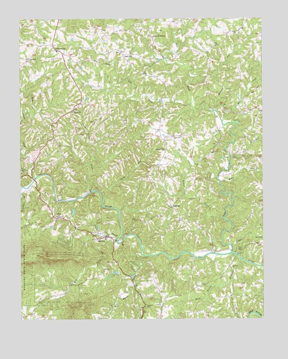
Danbury, NC USGS Topographic Map
Click on map above to begin viewing in our Map Viewer.

This topographic map contains these locations and features:
Feature Name Type Latitude Longitude GNIS ID View Map
Baker BranchStreamN36.4324°W80.1464°980444View Map
BoxwoodLocaleN36.4035°W80.1403°1007863View Map
Buck Island BridgeBridgeN36.4332°W80.2423°1952649View Map
Buck Island CreekStreamN36.4337°W80.2420°982109View Map
Camelot Woods DamDamN36.3968°W80.1998°1000582View Map
Camelot Woods LakeReservoirN36.3968°W80.1998°1000583View Map
DanburyPopulated PlaceN36.4093°W80.2059°1019902View Map
Danbury Courthouse SquareLocaleN36.4099°W80.2048°1007868View Map
Danbury Fire and Rescue DepartmentBuildingN36.4094°W80.2025°2638599View Map
Danbury Historic DistrictParkN36.4093°W80.2062°1952660View Map
Danbury Post OfficePost OfficeN36.4096°W80.2037°2773989View Map
Davis Chapel Methodist ChurchChurchN36.4046°W80.1359°984000View Map
Davis FordLocaleN36.4885°W80.1687°1007870View Map
Flat Shoal MountainSummitN36.3774°W80.2228°1952664View Map
Flat Shoals CreekStreamN36.4018°W80.1864°985190View Map
Hanging Rock State Park SiteLocaleN36.4293°W80.2470°1007869View Map
HartmanPopulated PlaceN36.4221°W80.1720°1006232View Map
Indian CreekStreamN36.4301°W80.2487°987354View Map
J S Hedgecock DamDamN36.3918°W80.2048°1000577View Map
J S Hedgecock LakeReservoirN36.3923°W80.2050°1000578View Map
James Martin PlantationLocaleN36.4465°W80.1498°1007864View Map
LawsonvillePopulated PlaceN36.4890°W80.2326°988232View Map
Lawsonville ChurchChurchN36.4615°W80.2223°988234View Map
Lawsonville ChurchChurchN36.4835°W80.2448°988235View Map
Lawsonville Elementary SchoolSchoolN36.4868°W80.2303°1006942View Map
Lawsonville Fire and RescueBuildingN36.4859°W80.2255°2638686View Map
Lawsonville Post OfficePost OfficeN36.4896°W80.2330°2681537View Map
Little Snow CreekStreamN36.4643°W80.1617°988776View Map
Lynn BranchStreamN36.4057°W80.1412°979998View Map
Meadows ChurchChurchN36.3962°W80.1412°989685View Map
Mill CreekStreamN36.4074°W80.2003°989934View Map
Mill CreekStreamN36.4574°W80.1456°989958View Map
Mitchells PondReservoirN36.4419°W80.1451°1000633View Map
Mitchells Pond Lower DamDamN36.4418°W80.1448°1000632View Map
Moores School (historical)SchoolN36.4887°W80.1495°1952693View Map
Moratuck FurnaceLocaleN36.4062°W80.1987°1007867View Map
Moratuck ParkParkN36.4068°W80.1981°1007866View Map
Moratuck Park SiteLocaleN36.4085°W80.1962°1007865View Map
Newman BranchStreamN36.4368°W80.2459°991130View Map
North View ChurchChurchN36.4512°W80.1700°991276View Map
Pioneer Community Hospital of StokesHospitalN36.4179°W80.2312°2701496View Map
Pleasant View Primitive Baptist ChurchChurchN36.4457°W80.1750°992582View Map
Raccoon CreekStreamN36.4618°W80.1492°992963View Map
Redman CreekStreamN36.4176°W80.1445°993146View Map
Sandy RunStreamN36.4218°W80.2070°994327View Map
Scott BranchStreamN36.4093°W80.1992°994425View Map
Scott LakeReservoirN36.4134°W80.2097°1000606View Map
Scott Lake DamDamN36.4135°W80.2098°1000607View Map
Seven Island CreekStreamN36.4282°W80.2139°994511View Map
Shepards Mill (historical)LocaleN36.4451°W80.1437°1952705View Map
Snow CreekStreamN36.4026°W80.1412°995064View Map
Snow HillPopulated PlaceN36.4854°W80.1967°1006376View Map
Snow Hill United Methodist ChurchChurchN36.4857°W80.1976°1952708View Map
Spencer-Hill Memorial ChurchChurchN36.4926°W80.1814°995296View Map
Stedman LakeReservoirN36.4200°W80.2226°1000612View Map
Stedman Lake DamDamN36.4218°W80.2231°1000613View Map
Stokes CountyCivilN36.4019°W80.2395°1008586View Map
Stokes County CourthouseBuildingN36.4096°W80.2059°1952709View Map
Stokes County Emergency Medical Services - Unit 5BuildingN36.4183°W80.2316°2720646View Map
Stokes County Sheriffs OfficeBuildingN36.4135°W80.2163°2769737View Map
Taylor DamDamN36.4135°W80.2331°1000609View Map
Taylor LakeReservoirN36.4134°W80.2334°1000608View Map
Town of DanburyCivilN36.4113°W80.2123°2406352View Map
Township of DanburyCivilN36.4075°W80.2164°1027203View Map
Township of Peters CreekCivilN36.4870°W80.2333°1027205View Map
Ugly BranchStreamN36.4424°W80.1409°996406View Map
Upper Sawra Town (historical)Populated PlaceN36.3996°W80.1503°1952711View Map
Wood Benton BranchStreamN36.4004°W80.1367°997560View Map
Youngs School (historical)SchoolN36.4399°W80.1584°1952746View Map

Note: Coordinates in the location and feature list above are referenced to NAD83 datum.


Copyright (C) 2008-2025 Ryan Niemi / Sunset Dynamics ... All Rights Reserved