TopoQuest Logo
Do you find TopoQuest useful?
Help keep TopoQuest running and adding new maps/features by donating!
Bitcoin:  19c7KJd3qBynnjoSw5npx9KScwjBe4ifkT
Litecoin:  LXs6TkuXGGXo1vDsWCkWVdjQX94eUKd6ui
Home View Maps Find Maps Find Places Resources & Links


Murdock, Florida Topographic Map

USGS Map Title: Murdock, FL
USGS Map MRC: 27082A2
DRG (GeoTIFF) Download: o27082a2.tif


Neighboring USGS Topographic Map Quads:


  Lower Myakka Lake, FL  
27082B3
 

  Murdock NW, FL  
27082B2
 

  Murdock NE, FL  
27082B1
 

  Myakka River, FL  
27082A3
 

  Murdock, FL  
27082A2
 

  Murdock SE, FL  
27082A1
 

  Englewood, FL  
26082H3
 

  El Jobean, FL  
26082H2
 

  Punta Gorda, FL  
26082H1


Map MRC Location:

N28°
W83°
N28°
W82°
H8 H7 H6 H5 H4 H3 H2 H1
G8 G7 G6 G5 G4 G3 G2 G1
F8 F7 F6 F5 F4 F3 F2 F1
E8 E7 E6 E5 E4 E3 E2 E1
D8 D7 D6 D5 D4 D3 D2 D1
C8 C7 C6 C5 C4 C3 C2 C1
B8 B7 B6 B5 B4 B3 B2 B1
A8 A7 A6 A5 A4 A3 A2 A1
N27°
W83°
N27°
W82°

Murdock, FL USGS 1:24K Topographic Map Preview:
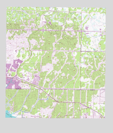
Murdock, FL USGS Topographic Map
Click on map above to begin viewing in our Map Viewer.

This topographic map contains these locations and features:
Feature Name Type Latitude Longitude GNIS ID View Map
Charlotte County Fire and Emergency Medical Services Station 15BuildingN27.0103°W82.2330°2644485View Map
Charlotte County Fire and Emergency Medical Services Station 2BuildingN27.0046°W82.1568°2131617View Map
Charlotte County Sheriff's OfficeBuildingN27.0160°W82.1548°2333596View Map
Charlotte County Sheriff's Office District 2BuildingN27.0085°W82.1496°2333584View Map
City Center Post OfficePost OfficeN27.0747°W82.2073°2783475View Map
City of North PortCivilN27.0576°W82.1977°2404398View Map
Cocoplum WaterwayCanalN27.0334°W82.1729°280624View Map
Little Salt SpringLakeN27.0749°W82.2331°285805View Map
MurdockPopulated PlaceN27.0128°W82.1462°287474View Map
Murdock Post OfficePost OfficeN27.0062°W82.1357°2451951View Map
North PortPopulated PlaceN27.0442°W82.2359°294334View Map
North Port DivisionCivilN27.0695°W82.1829°1935873View Map
North Port Elementary SchoolSchoolN27.0467°W82.2498°299260View Map
North Port Fire Rescue District Station 81BuildingN27.0738°W82.2080°2131599View Map
North Port Fire Rescue District Station 82BuildingN27.0467°W82.2343°2131600View Map
North Port Fire Rescue District Station 84BuildingN27.0690°W82.1665°2131602View Map
North Port Police DepartmentBuildingN27.0758°W82.2079°2333777View Map
North Port Police DepartmentBuildingN27.0470°W82.2343°2333778View Map
Port Charlotte High SchoolSchoolN27.0048°W82.1508°297282View Map
Port Charlotte Station Railroad StationLocaleN27.0128°W82.1473°300296View Map
Port Charlotte Town Center MallLocaleN27.0090°W82.1474°2451957View Map
Restlawn Memorial GardensCemeteryN27.0101°W82.2234°298068View Map
WKII-AM (Port Charlotte)TowerN27.0973°W82.1493°310126View Map

Note: Coordinates in the location and feature list above are referenced to NAD83 datum.


Copyright (C) 2008-2025 Ryan Niemi / Sunset Dynamics ... All Rights Reserved