TopoQuest Logo
Do you find TopoQuest useful?
Help keep TopoQuest running and adding new maps/features by donating!
Bitcoin:  19c7KJd3qBynnjoSw5npx9KScwjBe4ifkT
Litecoin:  LXs6TkuXGGXo1vDsWCkWVdjQX94eUKd6ui
Home View Maps Find Maps Find Places Resources & Links


Murdock SE, Florida Topographic Map

USGS Map Title: Murdock SE, FL
USGS Map MRC: 27082A1
DRG (GeoTIFF) Download: o27082a1.tif


Neighboring USGS Topographic Map Quads:


  Murdock NW, FL  
27082B2
 

  Murdock NE, FL  
27082B1
 

  Nocatee, FL  
27081B8
 

  Murdock, FL  
27082A2
 

  Murdock SE, FL  
27082A1
 

  Fort Ogden, FL  
27081A8
 

  El Jobean, FL  
26082H2
 

  Punta Gorda, FL  
26082H1
 

  Cleveland, FL  
26081H8


Map MRC Location:

N28°
W83°
N28°
W82°
H8 H7 H6 H5 H4 H3 H2 H1
G8 G7 G6 G5 G4 G3 G2 G1
F8 F7 F6 F5 F4 F3 F2 F1
E8 E7 E6 E5 E4 E3 E2 E1
D8 D7 D6 D5 D4 D3 D2 D1
C8 C7 C6 C5 C4 C3 C2 C1
B8 B7 B6 B5 B4 B3 B2 B1
A8 A7 A6 A5 A4 A3 A2 A1
N27°
W83°
N27°
W82°

Murdock SE, FL USGS 1:24K Topographic Map Preview:
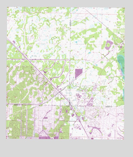
Murdock SE, FL USGS Topographic Map
Click on map above to begin viewing in our Map Viewer.

This topographic map contains these locations and features:
Feature Name Type Latitude Longitude GNIS ID View Map
Abacoa Golf ClubLocaleN27.0350°W82.0439°2452054View Map
Charlotte County Fire and Emergency Medical Services Station 12BuildingN27.0017°W82.0357°2131624View Map
Charlotte County Fire and Emergency Medical Services Station 8BuildingN27.0262°W82.0915°2131622View Map
Deep CreekPopulated PlaceN27.0170°W82.0151°2035736View Map
Deep Creek Rehab and Nursing CenterHospitalN27.0037°W82.0318°2044326View Map
First Baptist Community Christian SchoolSchoolN27.0012°W82.0762°299791View Map
Kingsway Country ClubLocaleN27.0360°W82.0439°2447560View Map
Lake Suzy (not official)Populated PlaceN27.0381°W82.0370°1781943View Map
Lake Suzy Estates AirportAirportN27.0426°W82.0437°309841View Map
Neil Armstrong Elementary SchoolSchoolN27.0034°W82.0871°299792View Map
North Port Fire Rescue District Station 83BuildingN27.0683°W82.1183°2131601View Map
PlattPopulated PlaceN27.0920°W82.0018°295548View Map
Port Charlotte Middle SchoolSchoolN27.0007°W82.0759°2044339View Map
Port Charlotte Village Mobile Home ParkPopulated PlaceN27.0131°W82.0489°2451956View Map
SidellPopulated PlaceN27.1178°W82.1165°300881View Map
Stonecrest Country ClubLocaleN27.0089°W82.0148°2452057View Map

Note: Coordinates in the location and feature list above are referenced to NAD83 datum.


Copyright (C) 2008-2025 Ryan Niemi / Sunset Dynamics ... All Rights Reserved