TopoQuest Logo
Do you find TopoQuest useful?
Help keep TopoQuest running and adding new maps/features by donating!
Bitcoin:  19c7KJd3qBynnjoSw5npx9KScwjBe4ifkT
Litecoin:  LXs6TkuXGGXo1vDsWCkWVdjQX94eUKd6ui
Home View Maps Find Maps Find Places Resources & Links


Namakan Island, Minnesota Topographic Map

USGS Map Title: Namakan Island, MN
USGS Map MRC: 48092D6
DRG (GeoTIFF) Download: o48092d6.tif


Neighboring USGS Topographic Map Quads:


  Kempton Bay, MN  
48092E7
 

  Kettle Falls, MN  
48092E6


  Ash River NE, MN  
48092D7
 

  Namakan Island, MN  
48092D6
 

  O'Leary Lake, MN  
48092D5
 

  Ash River SE, MN  
48092C7
 

  Marion Lake, MN  
48092C6
 

  Johnson Lake, MN  
48092C5


Map MRC Location:

N49°
W93°
N49°
W92°
H8 H7 H6 H5 H4 H3 H2 H1
G8 G7 G6 G5 G4 G3 G2 G1
F8 F7 F6 F5 F4 F3 F2 F1
E8 E7 E6 E5 E4 E3 E2 E1
D8 D7 D6 D5 D4 D3 D2 D1
C8 C7 C6 C5 C4 C3 C2 C1
B8 B7 B6 B5 B4 B3 B2 B1
A8 A7 A6 A5 A4 A3 A2 A1
N48°
W93°
N48°
W92°

Namakan Island, MN USGS 1:24K Topographic Map Preview:
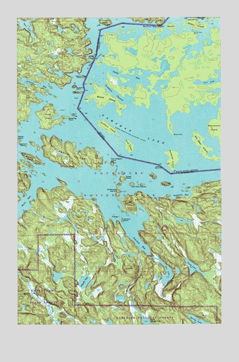
Namakan Island, MN USGS Topographic Map
Click on map above to begin viewing in our Map Viewer.

This topographic map contains these locations and features:
Feature Name Type Latitude Longitude GNIS ID View Map
Alden IslandIslandN48.4696°W92.7121°660641View Map
Bivo IslandIslandN48.4602°W92.7154°660818View Map
Fox IslandIslandN48.4352°W92.6665°661315View Map
Gagnon IslandIslandN48.4760°W92.7093°661335View Map
Gehering PointCapeN48.4593°W92.7190°661346View Map
Gold IslandIslandN48.4388°W92.6624°661371View Map
Hamilton IslandIslandN48.4174°W92.6854°661412View Map
Hoist BayBayN48.4244°W92.7463°661483View Map
Johnson BayBayN48.4730°W92.7371°661587View Map
Johnson RiverStreamN48.4044°W92.6749°661593View Map
Jug IslandIslandN48.4321°W92.6590°661600View Map
Junction BayBayN48.4082°W92.6757°661602View Map
Kettle FallsFallsN48.4993°W92.6390°663186View Map
Kettle Falls DamDamN48.4996°W92.6388°661638View Map
Kubel IslandIslandN48.4596°W92.7310°661666View Map
Magie IslandIslandN48.4535°W92.7496°660511View Map
McManus IslandIslandN48.4291°W92.6890°661891View Map
Mica IslandIslandN48.4982°W92.6949°661916View Map
Namakan IslandIslandN48.4438°W92.7174°662023View Map
Namakan LakeLakeN48.4280°W92.6487°662024View Map
Namakan Seaplane BaseAirportN48.4066°W92.6668°660616View Map
Net LakeLakeN48.3957°W92.6585°662037View Map
Postage IslandIslandN48.4188°W92.6874°662221View Map
Randolph BayBayN48.4277°W92.6502°662250View Map
Sexton IslandIslandN48.4502°W92.7496°662415View Map
Sheen IslandIslandN48.4360°W92.6857°662422View Map
Sheen PointCapeN48.4249°W92.6863°662423View Map
Squirrel NarrowsChannelN48.4971°W92.6668°662532View Map
Stevens IslandIslandN48.4424°W92.7399°662548View Map
Strawberry IslandIslandN48.4718°W92.7146°662568View Map
Tooth LakeLakeN48.3980°W92.6425°662660View Map
Twin Alligator IslandIslandN48.4407°W92.6918°662685View Map
Voyageur NarrowsChannelN48.4824°W92.7024°662531View Map
Weir LakeLakeN48.4969°W92.7427°662759View Map
Wigwam IslandIslandN48.4482°W92.7446°662798View Map
Wiyapka LakeLakeN48.3925°W92.7094°662814View Map
Wolf Pack IslandsIslandN48.4319°W92.6765°662825View Map

Note: Coordinates in the location and feature list above are referenced to NAD83 datum.


Copyright (C) 2008-2025 Ryan Niemi / Sunset Dynamics ... All Rights Reserved