TopoQuest Logo
Do you find TopoQuest useful?
Help keep TopoQuest running and adding new maps/features by donating!
Bitcoin:  19c7KJd3qBynnjoSw5npx9KScwjBe4ifkT
Litecoin:  LXs6TkuXGGXo1vDsWCkWVdjQX94eUKd6ui
Home View Maps Find Maps Find Places Resources & Links


Narrowsburg, New York Topographic Map

USGS Map Title: Narrowsburg, NY
USGS Map MRC: 41075E1
DRG (GeoTIFF) Download: o41075e1.tif


Neighboring USGS Topographic Map Quads:


  Galilee, PA  
41075F2
 

  Damascus, PA  
41075F1
 

  Lake Huntington, NY  
41074F8
 

  White Mills, PA  
41075E2
 

  Narrowsburg, NY  
41075E1
 

  Eldred, NY  
41074E8
 

  Hawley, PA  
41075D2
 

  Rowland, PA  
41075D1
 

  Shohola, PA  
41074D8


Map MRC Location:

N42°
W76°
N42°
W75°
H8 H7 H6 H5 H4 H3 H2 H1
G8 G7 G6 G5 G4 G3 G2 G1
F8 F7 F6 F5 F4 F3 F2 F1
E8 E7 E6 E5 E4 E3 E2 E1
D8 D7 D6 D5 D4 D3 D2 D1
C8 C7 C6 C5 C4 C3 C2 C1
B8 B7 B6 B5 B4 B3 B2 B1
A8 A7 A6 A5 A4 A3 A2 A1
N41°
W76°
N41°
W75°

Narrowsburg, NY USGS 1:24K Topographic Map Preview:
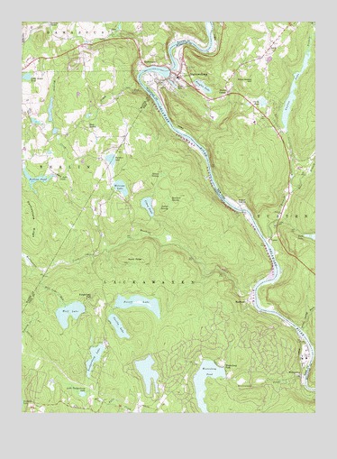
Narrowsburg, NY USGS Topographic Map
Click on map above to begin viewing in our Map Viewer.

This topographic map contains these locations and features:
Feature Name Type Latitude Longitude GNIS ID View Map
AtcoPopulated PlaceN41.6212°W75.0857°1192085View Map
Beach Lake CreekStreamN41.5751°W75.1046°1192099View Map
BranningvillePopulated PlaceN41.6206°W75.0879°1212933View Map
Camp ColangLocaleN41.5176°W75.0035°1192232View Map
Cattail SwampSwampN41.5647°W75.0612°1192243View Map
Central Volunteer Fire DepartmentBuildingN41.5029°W75.0641°2652762View Map
Clarks PondLakeN41.5993°W75.0223°946786View Map
Cobey DamDamN41.5634°W75.0696°1195660View Map
Cobey PondReservoirN41.5662°W75.0710°1192282View Map
Corilla LakeLakeN41.5276°W75.0835°1192298View Map
DarbytownPopulated PlaceN41.6109°W75.0693°1192327View Map
Darbytown FallsFallsN41.6062°W75.0766°1201376View Map
Deep Hollow HillSummitN41.6065°W75.0266°948173View Map
East BerlinPopulated PlaceN41.5915°W75.0960°1205040View Map
East Branch Tenmile RiverStreamN41.5709°W75.0093°949016View Map
Fawn Lake ForestPopulated PlaceN41.5084°W75.0643°1212932View Map
Fawn Lake Forest Census Designated PlaceCensusN41.5158°W75.0548°2633835View Map
Feagles LakeReservoirN41.6044°W75.0476°949947View Map
Forest LakeReservoirN41.5349°W75.0750°1192477View Map
Forest Lake DamDamN41.5301°W75.0729°1195643View Map
Forest Lake ParkPopulated PlaceN41.5365°W75.0949°1198315View Map
Glen Cove CemeteryCemeteryN41.6099°W75.0559°951174View Map
Grassy Swamp BrookStreamN41.5268°W75.0057°951580View Map
Hunts CornerPopulated PlaceN41.6026°W75.0374°972640View Map
Lackawaxen Township Volunteer Ambulance Service Bohemia StationBuildingN41.5015°W75.0948°2722134View Map
LavaPopulated PlaceN41.6168°W75.0191°972711View Map
Lava CemeteryCemeteryN41.6131°W75.0226°955098View Map
Lava Volunteer Fire DepartmentBuildingN41.6186°W75.0176°2718653View Map
Little Beach PondLakeN41.6074°W75.1224°1192791View Map
Little Teedyuskung LakeLakeN41.5060°W75.0987°1192821View Map
Luxton LakeLakeN41.5935°W75.0122°956158View Map
MasthopePopulated PlaceN41.5359°W75.0282°1192901View Map
Masthope Census Designated PlaceCensusN41.5154°W75.0257°2633836View Map
Masthope CreekStreamN41.5393°W75.0254°1192902View Map
Masthope RapidsPopulated PlaceN41.5173°W75.0216°1212931View Map
Masthope Ski AreaLocaleN41.5143°W75.0310°1205843View Map
NarrowsburgPopulated PlaceN41.6087°W75.0618°958272View Map
Narrowsburg Census Designated PlaceCensusN41.6006°W75.0579°2389529View Map
Narrowsburg Fire DepartmentBuildingN41.6081°W75.0595°2718425View Map
Panther LakeLakeN41.5810°W75.0867°1193081View Map
Peggy RunStreamN41.6040°W75.0729°1193096View Map
Perkins PondReservoirN41.5750°W75.1184°1193106View Map
Perkins Pond DamDamN41.5784°W75.1232°1208768View Map
Point PeterCapeN41.5484°W75.0729°1193145View Map
Rattlesnake CreekStreamN41.5526°W75.0885°1193171View Map
Rattlesnake RidgeRidgeN41.5637°W75.1216°1184675View Map
Rowland SwampSwampN41.5679°W75.0620°1193234View Map
Saint Francis ChurchChurchN41.6070°W75.0579°963491View Map
Saint Francis Xavier CemeteryCemeteryN41.6056°W75.0556°2061713View Map
Simmons SchoolSchoolN41.5759°W75.0846°1197884View Map
Spruce SwampSwampN41.5758°W75.0646°1193426View Map
Teedyuskung LakeReservoirN41.5177°W75.0936°1193514View Map
Tenmile RiverStreamN41.5545°W75.0202°967160View Map
TustenPopulated PlaceN41.5554°W75.0191°973169View Map
Tusten CemeteryCemeteryN41.5601°W75.0167°968002View Map
Tusten StationLocaleN41.5665°W75.0318°968004View Map
Tusten Volunteer Ambulance ServiceBuildingN41.6071°W75.0535°2718253View Map
Upper Delaware Scenic and Recreational RiverParkN41.5170°W75.0097°1888970View Map
Welcome LakeLakeN41.5721°W75.0824°1193621View Map
Welcome Lake Fire and Rescue Station 26BuildingN41.5811°W75.0904°2653548View Map
WestcolangPopulated PlaceN41.5129°W75.0052°1205099View Map
Westcolang CreekStreamN41.5112°W75.0043°1193645View Map
Westcolang Lake DamDamN41.5118°W75.0379°1195631View Map
Westcolang ParkPopulated PlaceN41.5145°W75.0385°1190956View Map
Westcolang PondReservoirN41.5142°W75.0449°1199773View Map
Wolf LakeLakeN41.5319°W75.1042°1193683View Map
Wolf Lake RunStreamN41.5445°W75.1154°1193684View Map

Note: Coordinates in the location and feature list above are referenced to NAD83 datum.


Copyright (C) 2008-2024 Ryan Niemi / Sunset Dynamics ... All Rights Reserved